
Historic churches · East of England
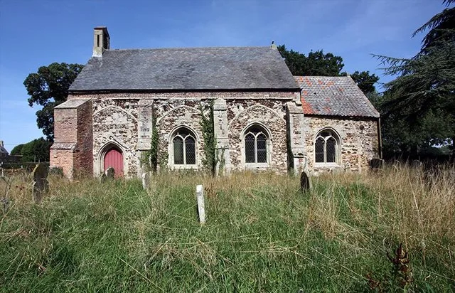
St Mary's Church, Fordham
In or near Fordham.
St Mary's Church, Fordham — church in Fordham, UK.

Wikimedia Commons contributors — see linked file page for photographer and licence licence

Plan your visit
- Typical visit
- 30 min–1 h
- Nearest railway station
- Downham Market · 3.9 km
- Free entry
Getting there & planning your visit
St Mary's Church in Fordham is located at postcode PE38 0LW and is accessible via the nearest railway station, Downham Market, which is 3.9 km away. Entry to the church is free.
About
St Mary's Church, Fordham is a historic church in the United Kingdom. Built in the English Gothic architecture style. Heritage designation: Grade II* listed building. Wikidata describes it as: "church in Fordham, UK". Coordinates: 52.5706°, 0.3838°.
Photo gallery
Heritage listing
St Mary's Church is located to the south of the village of Fordham, Norfolk, England. It is a redundant Anglican parish church in the care of the Friends of Friendless Churches. The church is recorded in the National Heritage List for England as a designated Grade II* listed building.
From the Historic England List Entry under OGL v3.
From the Wikipedia article
St Mary's Church is located to the south of the village of Fordham, Norfolk, England. It is a redundant Anglican parish church in the care of the Friends of Friendless Churches. The church is recorded in the National Heritage List for England as a designated Grade II* listed building.
Excerpt from Wikipedia under CC BY-SA 4.0. See the source article linked in Sources below.
Background
History
The church dates from the 13th century, with alterations made in the middle of the 14th century, and in 1730. and was vested in the Friends of Friendless Churches in September 2011.
Architecture
St Mary's in constructed in carstone, It has a simple plan, consisting of a nave and a chancel. The nave has a slate roof, and the chancel is roofed with tiles. On the west gable is a bell-cot. The former three-bay south arcade has been blocked in and two two-light windows with Perpendicular tracery have been inserted. The south wall of the chancel and the north wall of the nave each contain a similar widows. Also in the north wall of the nave is a three-light window, and in the chancel is a two-light window with Y-tracery, There is no east window. There are few remaining contents inside the church. The items still present include a floriated coffin lid, and the remains of a damaged…
Sourced from Wikipedia under CC BY-SA 4.0.
- Coordinates
- 52.5706, 0.3838
- County
- Norfolk
- District
- King's Lynn and West Norfolk
- Parish
- Fordham
- Postcode
- PE38 0LW
- Parliamentary constituency
- South West Norfolk
- Nearest railway station
- Downham Market — 3.9 km
Sources
- wikidata: Q7594328 (CC0)
- wikipedia: St Mary's Church, Fordham (CC BY-SA 4.0)
- commons: St Mary, Fordham, Norfolk - geograph.org.uk - 1449351.jpg (CC BY-SA 4.0)
Other places nearby
Fordham
Towns & cities · 0.1 km

Hilgay
Villages · 1.3 km

Hilgay Village Sign
Public art & sculpture · 1.3 km
Hilgay War Memorial
Memorials & monuments · 1.4 km

Kett's Oak
Natural landmarks · 1.4 km
.jpg?width=1200)
Ryston Hall
Historic houses · 1.7 km

Denver Windmill
Mills · 1.9 km
Denver Windmill
Windmills · 1.9 km

Denver and District War Memorial
Memorials & monuments · 1.9 km
Denver War Memorial
Memorials & monuments · 1.9 km

Denver
Villages · 2.0 km
Denver, Norfolk
Museums · 2.0 km
Nearby
Flagship📷 10Towns & cities · East of England
Fordham
Fordham — village and civil parish in the English county of Norfolk.
📷 5📷 5Public art & sculpture · East of England
Hilgay Village Sign
Hilgay Village Sign — a public art in East of England, United Kingdom.
📷 5Memorials & monuments · East of England
Hilgay War Memorial
Hilgay War Memorial — Grade II listed building-listed memorial in england-london, United Kingdom.
📷 5Natural landmarks · East of England
Kett's Oak
Kett's Oak — a place in East of England, United Kingdom.
📷 5Where to eat & stay near St Mary's Church, Fordham
Places to stay
 📷 5
📷 5Caravan parks · East of England
Lakeside Caravan Park (and Fishing Lakes)
Lakeside Caravan Park (and Fishing Lakes) — a caravan park in england london.
 📷 4
📷 4Caravan parks · East of England
Croft Country Club
Croft Country Club — a caravan park in england london.
 📷 4
📷 4Caravan parks · East Midlands
Westerby Farm Touring Caravan and Camping Park
Westerby Farm Touring Caravan and Camping Park — a caravan park in england london.
 📷 5
📷 5 📷 5
📷 5Campsites · East of England
Fen View Lakes
Fen View Lakes — a campsite in england london.
 📷 5
📷 5Caravan parks · East of England
The Paddock Caravan Site
The Paddock Caravan Site — a caravan park in england london.
Places to eat & drink
 📷 5
📷 5Historic pubs · East of England
Sportsman Public House
Sportsman Public House in England East, United Kingdom.
 📷 5
📷 5 📷 5
📷 5Restaurants · East Midlands
Imperial
Imperial — a restaurant in england london.
 📷 5
📷 5 📷 5
📷 5Historic pubs · East of England
Globe Hotel
Globe Hotel in England East, United Kingdom.
 📷 5
📷 5Historic pubs · East of England
Crown And Mitre Public House
Crown And Mitre Public House in England East, United Kingdom.
More places in this region
 📷 5
📷 5Historic churches · East of England
All Saints Church
All Saints Church — church on Jesus Lane in central Cambridge, England.
 📷 5
📷 5Historic churches · East of England
All Saints Church, Conington
All Saints Church, Conington — church in Conington, Huntingdonshire, Cambridgeshire, England, UK.
 📷 5
📷 5Historic churches · East of England
All Saints Church, Vange
All Saints Church, Vange — church in Basildon, Essex, England, UK.
 📷 5
📷 5Historic churches · East of England
All Saints Parish Church, Kirtling
All Saints Parish Church, Kirtling — church in East Cambridgeshire, England, UK.
Frequently asked questions
- Where is St Mary's Church, Fordham?
- St Mary's Church, Fordham is in Norfolk, East of England, United Kingdom (postcode PE38 0LW), in the parish of Fordham.
- What is St Mary's Church, Fordham?
- St Mary's Church, Fordham — church in Fordham, UK.
- How do I get to St Mary's Church, Fordham?
- The nearest railway station is Downham Market, about 3.9 km away. The nearest town is Fordham. Drivers can use postcode PE38 0LW.
- Is St Mary's Church, Fordham a listed building?
- St Mary's Church, Fordham is officially recognised as Grade II* listed building listed.
- Is St Mary's Church, Fordham free to visit?
- Yes, St Mary's Church, Fordham is free to enter.
- How do I get to St Mary's Church, Fordham?
- The nearest railway station is Downham Market, about 3.9 km away. Drivers can navigate to postcode PE38 0LW.