
Historic churches · East of England
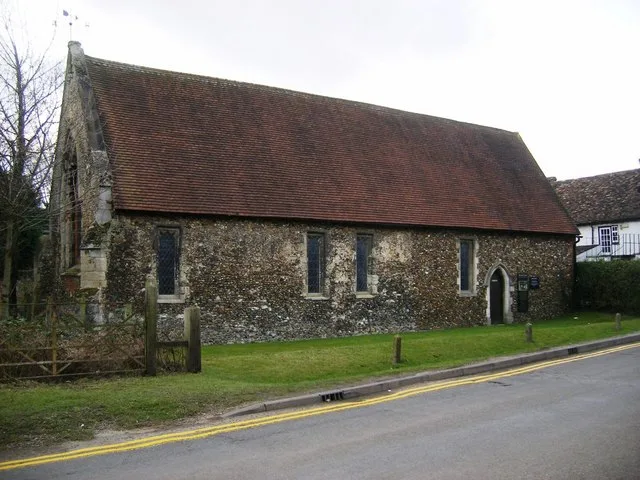
St John's Church, Duxford
In or near Duxford.
St John's Church, Duxford — church in Duxford, Cambridgeshire, England, UK.

Wikimedia Commons contributors — see linked file page for photographer and licence licence

Plan your visit
- Typical visit
- 30 min–1 h
- Nearest railway station
- Whittlesford Parkway · 1.2 km
- Free entry
Getting there & planning your visit
St John's Church in Duxford can be reached by taking a train to Whittlesford Parkway, which is 1.2 km away. The postcode for the church is CB22 4RA. Entry to the church is free.
About
St John's Church, Duxford is a historic church in the United Kingdom. Records date its origin to 1150. Built in the Norman architecture style. Heritage designation: Grade I listed building. Wikidata describes it as: "church in Duxford, Cambridgeshire, England, UK". Coordinates: 52.0944°, 0.1563°.
Photo gallery
Heritage listing
St John's Church, dedicated to St John the Baptist, is a redundant Anglican church in the village of Duxford, Cambridgeshire, England. In 1967 it was recorded in the National Heritage List for England as a designated Grade I listed building, and is now vested in The Churches Conservation Trust. The church stands on the junction of St John's Street and Green Street and is open daily, all year round to visitors.
From the Historic England List Entry under OGL v3.
Official information
St John's Church in Duxford is a historic church that offers visitors a glimpse into its architectural and cultural significance. The church is part of the Churches Conservation Trust, which works to preserve such sites for public enjoyment.
From the Wikipedia article
St John's Church, dedicated to St John the Baptist, is a redundant Anglican church in the village of Duxford, Cambridgeshire, England. In 1967 it was recorded in the National Heritage List for England as a designated Grade I listed building, and is now vested in The Churches Conservation Trust. The church stands on the junction of St John's Street and Green Street and is open daily, all year round to visitors.
Excerpt from Wikipedia under CC BY-SA 4.0. See the source article linked in Sources below.
Background
History
The tower, nave and chancel date from the late 12th century. During the following century the tower was raised and the chancel lengthened. A two-bay chapel was added to the north side of the chancel in about 1330. Later in the century windows were added to the lowest stage of the tower and to the west end of the nave. In the 15th century the north aisle and the porch were built, and the east window was added in the following century. In the 18th century repairs in brick were carried out. The north chapel was used as a schoolroom from the middle of the 17th century until about 1847. In 1874 the parish was united with the neighbouring parish of St Peter's Church, Duxford, and St John's became…
Architecture
The Norman round-headed tower arches date from the 12th century. The west arch has three attached columns, and the east arch has a single column. At the base of the east arch is a pair of carved dogs. In the chapel are two ogee-headed niches and a cinquefoil-headed piscina. There is a niche with a round head on the east wall of the nave. The font dates from the 13th century, and has a plain octagonal bowl on a clunch pedestal. The communion rail, dating from the late 17th century, has barley-twist balusters. The benches date from the late 15th century, and the floor tiles from the 18th century. In the chancel is a long desk with copious graffiti, of particular note are two small coffins…
Sourced from Wikipedia under CC BY-SA 4.0.
- Coordinates
- 52.0944, 0.1563
- County
- Cambridgeshire
- District
- South Cambridgeshire
- Parish
- Duxford
- Postcode
- CB22 4RA
- Parliamentary constituency
- South Cambridgeshire
- Established
- 1150
- Nearest railway station
- Whittlesford Parkway — 1.2 km
- Official site
- www.visitchurches.org.uk
Sources
- wikidata: Q7593547 (CC0)
- wikipedia: St John's Church, Duxford (CC BY-SA 4.0)
- commons: Duxford, St John's - geograph.org.uk - 2958.jpg (CC BY-SA 4.0)
Other places nearby

Duxford Village Cemetery
Cemeteries · 0.1 km

Duxford
Towns & cities · 0.3 km

Duxford (Cambridgeshire) War Memorial
Memorials & monuments · 0.3 km

Duxford Village Sign
Public art & sculpture · 0.3 km

Duxford Mill
Watermills · 0.5 km
Garden Sculpture North East Of Duxford Mill
Public art & sculpture · 0.6 km

Bethnal Green and King's Lynn Line
Historic bridges · 0.6 km

Bethnal Green and King's Lynn Line
Historic bridges · 1.0 km
Duxford Chapel
Chapels · 1.3 km
Boeing B-17G Flying Fortress - Sally B
Museums · 1.5 km

Airborne Assault
Museums · 1.6 km

Romano-British settlement site
Vineyards · 1.7 km
Nearby
📷 5Cemeteries · East of England
Duxford Village Cemetery
Duxford Village Cemetery is a cemetery in the United Kingdom.
📷 5Towns & cities · East of England
Duxford
Duxford — village and civil parish in Cambridgeshire, England.
📷 5Memorials & monuments · East of England
Duxford (Cambridgeshire) War Memorial
Duxford (Cambridgeshire) War Memorial — Grade II listed building-listed memorial in england-london, United Kingdom.
📷 5Public art & sculpture · East of England
Duxford Village Sign
Duxford Village Sign — a public art in East of England, United Kingdom.
📷 5📷 3Public art & sculpture · East of England
Garden Sculpture North East Of Duxford Mill
Garden Sculpture North East Of Duxford Mill in England East, United Kingdom.
Where to eat & stay near St John's Church, Duxford
Places to stay
 📷 7
📷 7Hotels · East of England
Crown House
Crown House — a hotel in england london.
 📷 5📷 5
 📷 5
📷 5Caravan parks · East of England
Caravan and Motorhome Club
Caravan and Motorhome Club — a caravan park in england london.
 📷 5
📷 5Caravan parks · East of England
Apple Acre Caravan Park
Apple Acre Caravan Park — a caravan park in england london.
 📷 5
📷 5Places to eat & drink
 📷 5
📷 5Historic pubs · East of England
Tickells Arms Public House
Tickells Arms Public House in England East, United Kingdom.
 📷 5
📷 5Historic pubs · East of England
The Navigator
The Navigator in England East, United Kingdom.
 📷 5
📷 5 📷 7
📷 7Historic pubs · East of England
Old Carpenters Arms
Old Carpenters Arms in England East, United Kingdom.
 📷 5
📷 5Historic pubs · East of England
The Kings Head Inn
The Kings Head Inn in England East, United Kingdom.
 📷 7
📷 7Other places from this era
 📷 5
📷 5Historic churches · London
All Hallows Staining
All Hallows Staining — church in City of London, UK.
 📷 5
📷 5Historic churches · London
All Hallows' Church, Tottenham
All Hallows' Church, Tottenham — church in Tottenham, London.
 📷 5
📷 5Historic churches · London
All Saints Church, Kingston upon Thames
All Saints Church, Kingston upon Thames — church in Kingston upon Thames, London.
 📷 5
📷 5Historic churches · London
All Saints' Church, Edmonton
All Saints' Church, Edmonton — church in Edmonton, London.
More places in this region
 📷 5
📷 5Historic churches · East of England
All Saints Church
All Saints Church — church on Jesus Lane in central Cambridge, England.
 📷 5
📷 5Historic churches · East of England
All Saints Church, Conington
All Saints Church, Conington — church in Conington, Huntingdonshire, Cambridgeshire, England, UK.
 📷 5
📷 5Historic churches · East of England
All Saints Church, Vange
All Saints Church, Vange — church in Basildon, Essex, England, UK.
 📷 5
📷 5Historic churches · East of England
All Saints Parish Church, Kirtling
All Saints Parish Church, Kirtling — church in East Cambridgeshire, England, UK.
Frequently asked questions
- Where is St John's Church, Duxford?
- St John's Church, Duxford is in Cambridgeshire, East of England, United Kingdom (postcode CB22 4RA), in the parish of Duxford.
- What is St John's Church, Duxford?
- St John's Church, Duxford — church in Duxford, Cambridgeshire, England, UK.
- How do I get to St John's Church, Duxford?
- The nearest railway station is Whittlesford Parkway, about 1.2 km away. The nearest town is Duxford. Drivers can use postcode CB22 4RA.
- When was St John's Church, Duxford built?
- Built or established in 1150.
- Is St John's Church, Duxford a listed building?
- St John's Church, Duxford is officially recognised as Grade I listed building listed.
- Is St John's Church, Duxford free to visit?
- Yes, St John's Church, Duxford is free to enter.
- How do I get to St John's Church, Duxford?
- The nearest railway station is Whittlesford Parkway, about 1.2 km away. Drivers can navigate to postcode CB22 4RA.