
Historic churches · South East England
St Giles' Church, Horsted Keynes
In or near Ardingly.
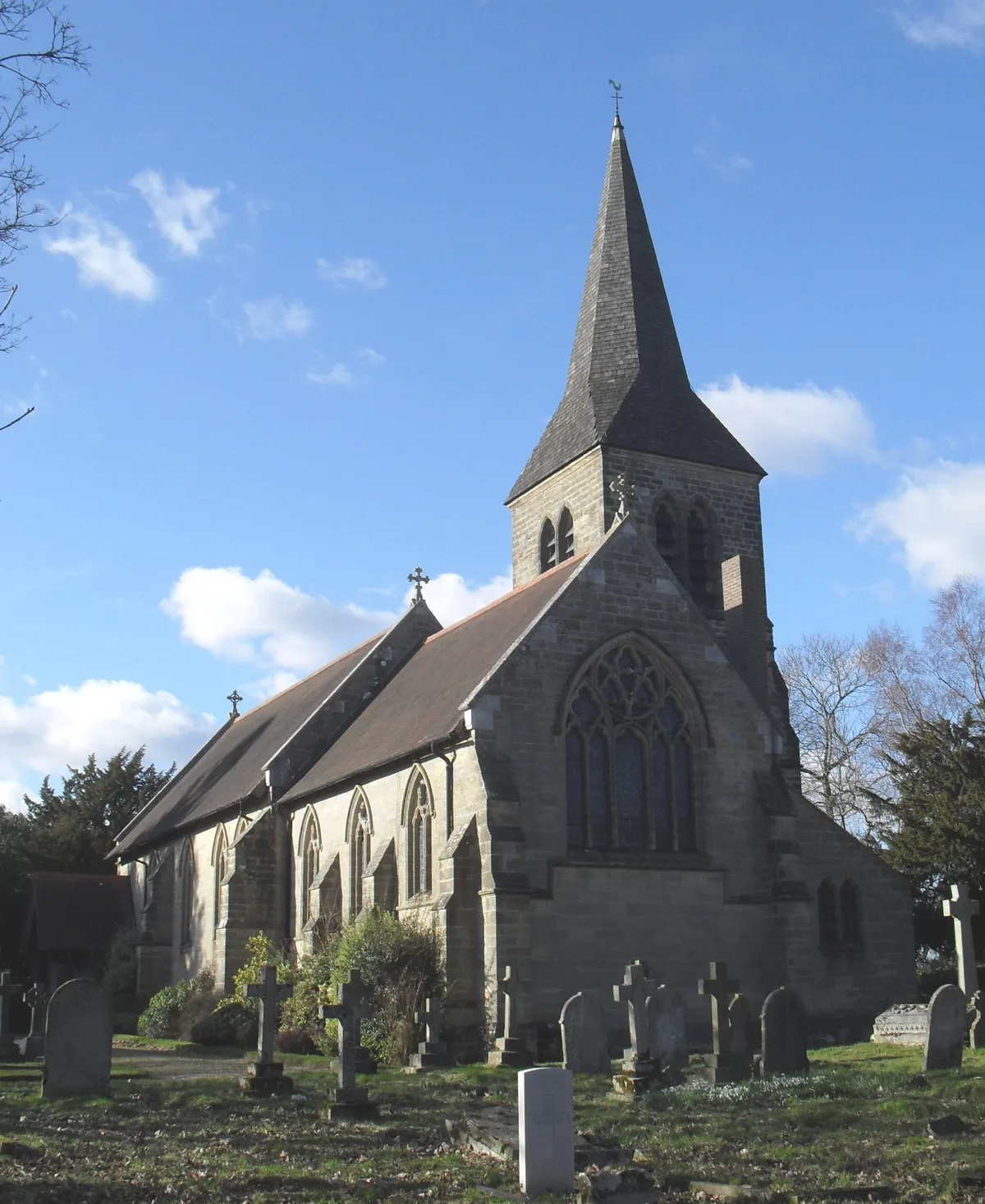
St Giles' Church, Horsted Keynes — church in Mid Sussex, England, UK.

Wikimedia Commons contributors — see linked file page for photographer and licence licence
.JPG)
Plan your visit
- Typical visit
- 30 min–1 h
- Nearest railway station
- Horsted Keynes · 1.4 km
- Free entry
Getting there & planning your visit
St Giles' Church is located in Horsted Keynes, West Sussex, with the nearest railway station being Horsted Keynes, approximately 1.4 km away. Entry to the church is free. The postcode for sat-nav is RH17 7AY.
About
St Giles' Church, Horsted Keynes is a historic church in the United Kingdom. Records date its origin to 1101. Built in the Norman architecture style. Heritage designation: Grade I listed building. Affiliated with Anglicanism. Wikidata describes it as: "church in Mid Sussex, England, UK". Coordinates: 51.0402°, -0.0281°.
Photo gallery
Heritage listing
St Giles' Church is an Anglican church in the village of Horsted Keynes in Mid Sussex, one of seven local government districts in the English county of West Sussex. Serving an extensive rural parish in the Sussex Weald, it stands at the north end of its village on the site of an ancient pagan place of worship. The present building succeeds the original wattle and daub church, its wooden successor and a Saxon stone building—although the Norman architects who erected the cruciform structure in the 12th century preserved parts of the Saxon fabric. Long established local families have been important in the life of the church for centuries, as indicated by the extensive range of memorials and fittings in the building and its large churchyard.
From the Historic England List Entry under OGL v3.
Official information
St Giles Church is a historic Church of England village church that has served the community for over a thousand years. It offers a welcoming environment for all generations, focusing on worship, prayer, and community involvement.
Protected designations
- Area of Outstanding Natural Beauty: High Weald
Designations sourced from Natural England open data under OGL v3.
From the Wikipedia article
St Giles' Church is an Anglican church in the village of Horsted Keynes in Mid Sussex, one of seven local government districts in the English county of West Sussex. Serving an extensive rural parish in the Sussex Weald, it stands at the north end of its village on the site of an ancient pagan place of worship. The present building succeeds the original wattle and daub church, its wooden successor and a Saxon stone building—although the Norman architects who erected the cruciform structure in the 12th century preserved parts of the Saxon fabric. Long established local families have been important in the life of the church for centuries, as indicated by the extensive range of memorials and fittings in the building and its large churchyard. The village got its name from the de Cahaignes family, one of whose ancestors is apparently commemorated by the rare 13th-century "heart shrine" in the chancel. Another family with more recent connections to the parish is the Macmillan publishing dynasty, the most famous of whose sons—former Prime Minister Harold Macmillan—is buried in the family plot. Various changes have been made to the Norman church, mostly in the 13th and 14th centuries, and some Victorian restoration was undertaken. Nevertheless, the building still retains its original cruciform shape and its central tower topped by a landmark broach spire. The church continues to play an active part in parish life, maintaining links to the local school and holding regular services. English Heritage has listed it at Grade I for its architectural and historical importance.
Excerpt from Wikipedia under CC BY-SA 4.0. See the source article linked in Sources below.
Background
History
Horsted Keynes is an ancient parish in the centre of Sussex, covering about 5000 acre of heavily forested, mostly rural land which forms part of the Weald. Nearly 480 acre was originally part of the ancient Forest of Anderida, and the soil consists of Hastings Sand and clay with several prominent sandstone ridges. The village stands on one of these. At the time of the Domesday survey in 1086, the parish of Horstede was in the Hundred of Ristone, the Church was struck by lightning. 3000 shingles came off the spire." Spencer Slingsby Stallwood, a Reading-based architect, was commissioned to carry out his only work at a Sussex church at St Giles' in 1885, in association with his colleague…
Architecture
s, sandstone walls and a stone porch.]] St Giles' Church stands on a northeast–southwest alignment. Its nave is 18° north of east and the chancel 13°; this skewed construction recalls the leftward tilting of Christ's head on the cross. In its present form, it is roughly cruciform and consists of a nave and shorter chancel separated by a crossing upon which the tower rests, a south transept, a north chapel, an arcaded north aisle and the remains of a south chapel and north transept. In the crossing, the round-headed east- and south-facing arches, each 6 ft high to the imposts, 10 ft high to the top of the arch and 6 ft wide, are from the original Norman building and are supported on four…
Visiting
St Giles' Church was listed at Grade I by English Heritage on 28 October 1957. Such buildings are defined as being of "exceptional interest" and greater than national importance. , it was one of 16 Grade I listed buildings, and 1,028 listed buildings of all grades, in the district of Mid Sussex. The ecclesiastical parish of Horsted Keynes covers a mostly rural area of Mid Sussex, much longer from north to south than it is wide. Part of the northern boundary runs along Top Road between West Hoathly and Sharpthorne. To the east, it follows the West Sussex/East Sussex county boundary from near Wych Cross to the River Ouse near Freshfield. The river then forms the southern boundary, and a…
Sourced from Wikipedia under CC BY-SA 4.0.
- Coordinates
- 51.0402, -0.0281
- County
- West Sussex
- District
- Mid Sussex
- Parish
- Horsted Keynes
- Postcode
- RH17 7AY
- Parliamentary constituency
- East Grinstead and Uckfield
- Phone
- 01825 791132
- Established
- 1101
- Nearest railway station
- Horsted Keynes — 1.4 km
- Official site
- www.stgileschurchhorstedkeynes.org.uk
Sources
- wikidata: Q7593261 (CC0)
- wikipedia: St Giles' Church, Horsted Keynes (CC BY-SA 4.0)
- commons: St Giles' Church, Horsted Keynes (NHLE Code 1025684).JPG (CC BY-SA 4.0)
Other places nearby

Horsted Keynes
Villages · 0.4 km

Waterbury Castle
Castles · 0.6 km

Ray Ward memorial
Memorials & monuments · 1.5 km

Bluebell Camp Site
Campsites · 1.7 km

The Old House
Historic houses · 2.3 km

Contraption
Public art & sculpture · 2.4 km

Phone Box Gallery
Museums · 2.6 km

Highbrook War Memorial
Memorials & monuments · 2.6 km
All Saints Church
Historic churches · 2.6 km

Wild Boar Wood Campsite
Campsites · 2.8 km
Wild Boar Wood
Campsites · 2.8 km

Tyes Cross
Villages · 3.0 km
Nearby
📷 5📷 5Castles · South East England
Waterbury Castle
Waterbury Castle — Grade II listed building-listed castle in england-south-east, United Kingdom.
📷 5Memorials & monuments · South East England
Ray Ward memorial
Ray Ward memorial — a memorial in South East England, United Kingdom.
📷 5Campsites · South East England
Bluebell Camp Site
Bluebell Camp Site — a campsite in england south east.
📷 5Historic houses · South East England
The Old House
The Old House — house in Horsted Keynes, Mid Sussex, England, UK.
📷 5Public art & sculpture · South East England
Contraption
Contraption — a public art in South East England, United Kingdom.
Where to eat & stay near St Giles' Church, Horsted Keynes
Places to stay
📷 5Campsites · South East England
Bluebell Camp Site
Bluebell Camp Site — a campsite in england south east.
📷 5Campsites · South East England
Wild Boar Wood Campsite
Wild Boar Wood Campsite — a campsite in england south east.
📷 5 📷 5
📷 5Campsites · South East England
Heaven Farm
Heaven Farm — a campsite in england south east.
 📷 5
📷 5Campsites · South East England
Hook Farm Campsite
Hook Farm Campsite — a campsite in england south east.
 📷 5
📷 5Campsites · South East England
Kitt's Cottage Campsite
Kitt's Cottage Campsite — a campsite in england south east.
Places to eat & drink
 📷 7
📷 7 📷 7
📷 7Historic pubs · South East England
The Sergison Arms Public House
The Sergison Arms Public House in England South East, United Kingdom.
 📷 5
📷 5Historic pubs · South East England
The Five Bells Inn
The Five Bells Inn in England South East, United Kingdom.
 📷 5
📷 5Historic pubs · South East England
The Jolly Tanners Public House
The Jolly Tanners Public House in England South East, United Kingdom.
 📷 5
📷 5 📷 5
📷 5Historic pubs · South East England
The Crowborough Cross
The Crowborough Cross in England South East, United Kingdom.
Other places from this era
 📷 5
📷 5Historic churches · London
All Hallows Staining
All Hallows Staining — church in City of London, UK.
 📷 5
📷 5Historic churches · London
All Hallows' Church, Tottenham
All Hallows' Church, Tottenham — church in Tottenham, London.
 📷 5
📷 5Historic churches · London
All Saints Church, Kingston upon Thames
All Saints Church, Kingston upon Thames — church in Kingston upon Thames, London.
 📷 5
📷 5Historic churches · London
All Saints' Church, Edmonton
All Saints' Church, Edmonton — church in Edmonton, London.
More places in this region
 📷 5
📷 5Historic churches · South East England
All Saints Church, Frindsbury
All Saints Church, Frindsbury — church in Medway, UK.
 📷 5
📷 5Historic churches · South East England
All Saints Church, Maidstone
All Saints Church, Maidstone — parish church associated with the Archbishop's Palace, Maidstone, Kent, England, UK.
 📷 5
📷 5Historic churches · South East England
All Saints Church, West Farleigh
All Saints Church, West Farleigh — Grade I listed church in West Farleigh, Maidstone, Kent, England, UK.
 📷 5
📷 5Historic churches · South East England
All Souls' Church, Sutton Green
All Souls' Church, Sutton Green — church in Guildford, England.
Frequently asked questions
- Where is St Giles' Church, Horsted Keynes?
- St Giles' Church, Horsted Keynes is in West Sussex, South-East England, United Kingdom (postcode RH17 7AY), in the parish of Horsted Keynes.
- What is St Giles' Church, Horsted Keynes?
- St Giles' Church, Horsted Keynes — church in Mid Sussex, England, UK.
- How do I get to St Giles' Church, Horsted Keynes?
- The nearest railway station is Horsted Keynes, about 1.4 km away. The nearest town is Ardingly. Drivers can use postcode RH17 7AY.
- When was St Giles' Church, Horsted Keynes built?
- Built or established in 1101.
- Is St Giles' Church, Horsted Keynes a listed building?
- St Giles' Church, Horsted Keynes is officially recognised as Grade I listed building listed.
- Is St Giles' Church, Horsted Keynes a protected site?
- Yes — St Giles' Church, Horsted Keynes is part of the High Weald National Landscape (AONB).
- Is St Giles' Church, Horsted Keynes free to visit?
- Yes, St Giles' Church, Horsted Keynes is free to enter.
- How do I get to St Giles' Church, Horsted Keynes?
- The nearest railway station is Horsted Keynes, about 1.4 km away. Drivers can navigate to postcode RH17 7AY.