Long-distance walking trails · South Wales
Pembrokeshire Coast Path
In or near Johnston.
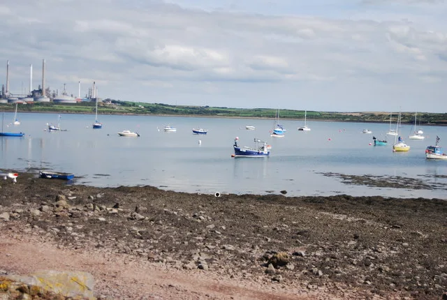
A 186-mile National Trail around the rugged coast of Pembrokeshire National Park from St Dogmaels in the north to Amroth in the south, taking in cliffs, beaches, fishing villages and offshore islands.

Eirian Evans — CC BY-SA 2.0 via Wikimedia Commons licence
Plan your visit
- Typical visit
- 1 h–2 h
- Nearest railway station
- Milford Haven · 3.8 km
About
A 186-mile National Trail around the rugged coast of Pembrokeshire National Park from St Dogmaels in the north to Amroth in the south, taking in cliffs, beaches, fishing villages and offshore islands.
Photo gallery
Place summary
The Pembrokeshire Coast Path is a walking trail located in South Wales. It follows the stunning coastline of Pembrokeshire, offering views of cliffs, beaches, and wildlife. This trail is known for its varied terrain and natural beauty, making it a popular choice for walkers and nature enthusiasts. It provides access to several coastal villages and sites of interest along the way.
AI-generated from the structured facts on this page (operator, designation, listing, era). Not a substitute for visiting.
- Coordinates
- 51.6817, -5.0431
- District
- Pembrokeshire
- Parish
- Angle
- Postcode
- SA71 5TA
- Parliamentary constituency
- Mid and South Pembrokeshire
- Nearest railway station
- Milford Haven — 3.8 km
Sources
- wikidata: Q1136228 (CC0)
Other places nearby

Eastington Manor House
Literary houses · 0.4 km

The Tower At Eastington Manor House
Gardens · 0.4 km

St Decuman's Church
Historic churches · 0.7 km

Rhoscrowther
Villages · 0.8 km

Popton Cross
Memorials & monuments · 1.3 km

Fort Popton
Forts · 1.3 km

West Popton Camp
Vineyards · 1.6 km

Milford Haven
Harbours & ports · 1.6 km
Angle Bay
Mountains & hills · 1.6 km

Newton Farm
Caravan parks · 2.2 km

Former Church Of Saint Mary, Pwllcrochan
Historic churches · 2.3 km

Enclosure & Earthworks at Lewiston Hall
Vineyards · 2.5 km
Nearby
📷 5Literary houses · South Wales
Eastington Manor House
Eastington Manor House — a literary house museum in wales south.
📷 3Gardens · South Wales
The Tower At Eastington Manor House
The Tower At Eastington Manor House — a garden in wales-south, United Kingdom.
📷 5Historic churches · South Wales
St Decuman's Church
St Decuman's Church — Grade I listed building-listed church in wales-south, United Kingdom.
📷 5📷 3Memorials & monuments · South Wales
Popton Cross
Popton Cross — a memorial in wales-south, United Kingdom.
📷 3Where to eat & stay near Pembrokeshire Coast Path
Places to stay
📷 5 📷 5
📷 5 📷 5
📷 5 📷 5
📷 5 📷 5
📷 5 📷 5
📷 5Places to eat & drink
 📷 5
📷 5
 📷 7
📷 7 📷 3
📷 3 📷 7
📷 7 📷 7
📷 7Restaurants · South Wales
The Stone Crab
The Stone Crab — a restaurant in wales south.
More places in this region
 📷 3
📷 3Long-distance walking trails · South Wales
Three Castles Walk, Monmouthshire
The Three Castles Walk is a waymarked long-distance footpath and recreational walk in north-east Monmouthshire, Wales, linking Skenfrith, Grosmont and White Castles.
 ★ Iconic📷 5
Long-distance walking trails · South Wales
Wales Coast Path
World's first whole-country coastal trail — 870 miles around all of Wales.
Frequently asked questions
- Where is Pembrokeshire Coast Path?
- Pembrokeshire Coast Path is in South Wales, United Kingdom (postcode SA71 5TA), in the parish of Angle.
- What is Pembrokeshire Coast Path?
- A 186-mile National Trail around the rugged coast of Pembrokeshire National Park from St Dogmaels in the north to Amroth in the south, taking in cliffs, beaches, fishing villages and offshore islands.
- How do I get to Pembrokeshire Coast Path?
- The nearest railway station is Milford Haven, about 3.8 km away. Drivers can use postcode SA71 5TA.
- How do I get to Pembrokeshire Coast Path?
- The nearest railway station is Milford Haven, about 3.8 km away. Drivers can navigate to postcode SA71 5TA.