
Historic churches · East Midlands
South Ormsby
In or near Little Cawthorpe.
South Ormsby, sometimes called South Ormesby, is a village in the East Lindsey district of Lincolnshire, England. It is situated 1 mile (1.6 km) west from the A16 road, 7 miles (11 km) south from Lout

JThomas — CC BY-SA 2.0 via Wikimedia Commons licence

Plan your visit
- Typical visit
- 30 min–1 h
- Free entry
About
South Ormsby, sometimes called South Ormesby, is a village in the East Lindsey district of Lincolnshire, England. It is situated 1 mile (1.6 km) west from the A16 road, 7 miles (11 km) south from Louth and 7 miles north-east from Horncastle. With the nearby hamlet of Ketsby, it forms the civil parish of South Ormesby with Ketsby. The population is included in the civil parish of Brinkhill. The 15th-century church of St Leonard's is approached by a short climb up a path next to the old school house. Ormsby Hall, built by James Paine in 1752, stands in a wooded parkland complete with lake. The village has a public house, the Massingberd Arms, and a motor repair garage. The Greenwich Prime Meridian line passes through the village.
Photo gallery
Protected designations
- Area of Outstanding Natural Beauty: Lincolnshire Wolds
Designations sourced from Natural England open data under OGL v3.
From the Wikipedia article
South Ormsby, sometimes called South Ormesby, is a village in the East Lindsey district of Lincolnshire, England. It is situated 1 mile (1.6 km) west from the A16 road, 7 miles (11 km) south from Louth and 7 miles north-east from Horncastle. With the nearby hamlet of Ketsby, it forms the civil parish of South Ormesby with Ketsby. The population is included in the civil parish of Brinkhill. The 15th-century church of St Leonard's is approached by a short climb up a path next to the old school house. Ormsby Hall, built by James Paine in 1752, stands in a wooded parkland complete with lake. The village has a public house, the Massingberd Arms, and a motor repair garage. The Greenwich Prime Meridian line passes through the village.
Excerpt from Wikipedia under CC BY-SA 4.0. See the source article linked in Sources below.
- Coordinates
- 53.2614, 0.0519
- County
- Lincolnshire
- District
- East Lindsey
- Parish
- South Ormsby cum Ketsby
- Postcode
- LN11 8QP
- Parliamentary constituency
- Louth and Horncastle
Sources
- wikipedia: South Ormsby (CC BY-SA 4.0)
Other places nearby

Massingberd Arms
Historic pubs · 0.0 km
.jpg?width=1200)
School House
Historic houses · 0.6 km
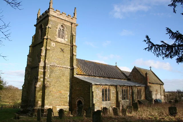
Church of St Leonard, South Ormsby
Historic churches · 0.6 km

Brinkhill
Historic churches · 2.2 km

Cloven Hill
Mountains & hills · 2.3 km

Worlaby
Villages · 2.4 km

Swaby
Historic churches · 2.5 km

Walmsgate
Historic churches · 2.6 km

Walmsgate
Vineyards · 2.6 km

Warden Hill
Mountains & hills · 3.2 km
Warden Hill
Mountains & hills · 3.2 km
Anderson Hill
Mountains & hills · 3.2 km
Nearby
📷 5Historic pubs · East Midlands
Massingberd Arms
Massingberd Arms in England East Midlands, United Kingdom.
📷 3Historic houses · East Midlands
School House
School House — house in South Ormsby cum Ketsby, East Lindsey, Lincolnshire, England, UK.
📷 3Historic churches · East Midlands
Church of St Leonard, South Ormsby
Church of St Leonard, South Ormsby — church in Lincolnshire, England, UK.
📷 5Historic churches · East Midlands
Brinkhill
Brinkhill — a church in england-east-midlands, United Kingdom.
📷 5Mountains & hills · East Midlands
Cloven Hill
Cloven Hill — mountain in england east midlands. Elevation: 95 m.
📷 5Where to eat & stay near South Ormsby
Places to stay
 📷 5
📷 5 📷 5
📷 5Campsites · East Midlands
Waggon & Horses Camping & Caravanning Site
Waggon & Horses Camping & Caravanning Site — a campsite in england east midlands.
 📷 5
📷 5Campsites · East Midlands
West End Farm
West End Farm — a campsite in england east midlands.
 📷 5
📷 5Caravan parks · East Midlands
Furze Farm Estate
Furze Farm Estate — a caravan park in england east midlands.
 📷 5
📷 5Campsites · East Midlands
Happyford CL
Happyford CL — a campsite in england east midlands.
 📷 5
📷 5Campsites · East Midlands
Ashby Park
Ashby Park — a campsite in england east midlands.
Places to eat & drink
📷 5Historic pubs · East Midlands
Massingberd Arms
Massingberd Arms in England East Midlands, United Kingdom.
 📷 5
📷 5 📷 5
📷 5 📷 5
📷 5 📷 5
📷 5 📷 5
📷 5Historic pubs · East Midlands
Lea Gate Public House
Lea Gate Public House in England East, United Kingdom.
More places in this region
 📷 5
📷 5Historic churches · East Midlands
All Saints' Church, Stamford
All Saints' Church, Stamford — church in Stamford, Lincolnshire, England, UK.
 📷 5
📷 5Historic churches · East Midlands
Church of All Saints
Church of All Saints — church in Little Casterton, Rutland, United Kingdom.
 📷 5
📷 5Historic churches · East Midlands
Church of All Saints
Church of All Saints — church in Fenland, UK.
 📷 5
📷 5Historic churches · East Midlands
Church of St Leonard
Church of St Leonard — church in Fenland, UK.
Frequently asked questions
- Where is South Ormsby?
- South Ormsby is in Lincolnshire, the East Midlands, United Kingdom (postcode LN11 8QP), in the parish of South Ormsby cum Ketsby.
- What is South Ormsby?
- South Ormsby, sometimes called South Ormesby, is a village in the East Lindsey district of Lincolnshire, England. It is situated 1 mile (1.6 km) west from the A16 road, 7 miles (11 km) south from Lout
- How do I get to South Ormsby?
- The nearest town is Little Cawthorpe. Drivers can use postcode LN11 8QP.
- Is South Ormsby a protected site?
- Yes — South Ormsby is part of the Lincolnshire Wolds National Landscape (AONB).
- Is South Ormsby free to visit?
- Yes, South Ormsby is free to enter.
- How do I get to South Ormsby?
- Drivers can navigate to postcode LN11 8QP. It sits within the Louth and Horncastle parliamentary constituency.