
Villages · East Midlands
South Leverton
In or near Bole.
South Leverton — a village in england east midlands.

Alan Murray-Rust — CC BY-SA 2.0 via Wikimedia Commons licence

Plan your visit
- Typical visit
- 1 h–2 h
- Nearest railway station
- Retford · 8.0 km
About
A British village — settlements of this size traditionally cluster a green, parish church, pub and post office around historic land routes.
Photo gallery
Place summary
South Leverton is a village located in the East Midlands, with a population of approximately 480 residents. The village features a rural setting typical of the region, characterised by its local community and surrounding agricultural land. South Leverton offers a glimpse into village life in the East Midlands, reflecting the area's historical and social fabric.
AI-generated from the structured facts on this page (operator, designation, listing, era). Not a substitute for visiting.
- Coordinates
- 53.3197, -0.8257
- County
- Nottinghamshire
- District
- Bassetlaw
- Parish
- South Leverton
- Postcode
- DN22 0BL
- Parliamentary constituency
- Newark
- Population
- 480
- Nearest railway station
- Retford — 8 km
Sources
- manual: geonames-2637383 (CC BY 4.0)
Other places nearby
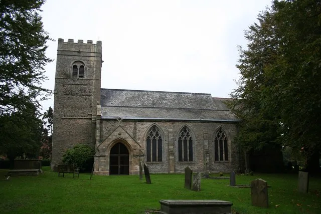
All Saints' Church, South Leverton
Historic churches · 0.2 km

North Leverton
Villages · 1.2 km

North Leverton Windmill
Windmills · 1.3 km

North Leverton War Memorial
Memorials & monuments · 1.3 km
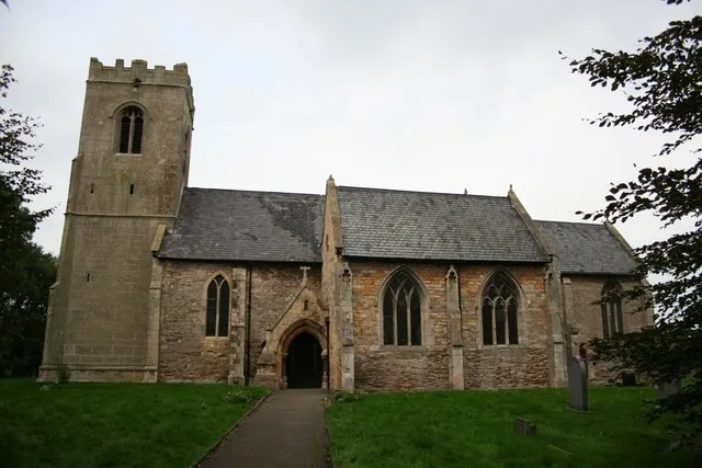
St Martin's Church, North Leverton
Historic churches · 1.4 km

Treswell
Villages · 1.7 km

Robin Hood Ride
Natural landmarks · 1.8 km
Sunnydown Farm
Farms (open to visitors) · 1.9 km
Toy Town
Natural landmarks · 1.9 km
Tractor Ride
Natural landmarks · 1.9 km
Storybook Village
Natural landmarks · 1.9 km
Sundown Adventureland
Theme parks · 1.9 km
Nearby
📷 3Historic churches · East Midlands
All Saints' Church, South Leverton
All Saints' Church, South Leverton — Grade II* church in South Leverton, Nottinghamshire, England, UK.
📷 5📷 3Windmills · East Midlands
North Leverton Windmill
North Leverton Windmill is a windmill in the United Kingdom.
📷 3Memorials & monuments · East Midlands
North Leverton War Memorial
North Leverton War Memorial — Grade II listed building-listed memorial in england-east-midlands, United Kingdom.
📷 5Historic churches · East Midlands
St Martin's Church, North Leverton
St Martin's Church, North Leverton — church in Bassetlaw, UK.
📷 5Where to eat & stay near South Leverton
Places to stay
 📷 5
📷 5Campsites · East Midlands
Trentfield Farm
Trentfield Farm — a campsite in england east midlands.
 📷 5
📷 5Caravan parks · East Midlands
Manor House Caravan Park
Manor House Caravan Park — a caravan park in england east midlands.
 📷 5
📷 5Caravan parks · East Midlands
Little London Park
Little London Park — a caravan park in england east midlands.
 📷 5
📷 5 📷 5
📷 5 📷 5
📷 5Campsites · East Midlands
Greenacres Caravan and Touring Park
Greenacres Caravan and Touring Park — a campsite in england east midlands.
Places to eat & drink
 📷 5
📷 5Historic pubs · East Midlands
Ingelby Arms Public House
Ingelby Arms Public House in England Yorkshire, United Kingdom.
 📷 5
📷 5 📷 5
📷 5Historic pubs · East Midlands
New Inn Public House
New Inn Public House in England Yorkshire, United Kingdom.
 📷 7
📷 7Historic pubs · East Midlands
Black Boy Public House
Black Boy Public House in England Yorkshire, United Kingdom.
 📷 5
📷 5 📷 5
📷 5Historic pubs · East Midlands
Newcastle Arms Public House
Newcastle Arms Public House in England Yorkshire, United Kingdom.
More places in this region
 📷 5
📷 5 📷 5
📷 5 📷 5
📷 5 📷 5
📷 5Frequently asked questions
- Where is South Leverton?
- South Leverton is in Nottinghamshire, the East Midlands, United Kingdom (postcode DN22 0BL), in the parish of South Leverton.
- What is South Leverton?
- South Leverton — a village in england east midlands.
- How do I get to South Leverton?
- The nearest railway station is Retford, about 8.0 km away. The nearest town is Bole. Drivers can use postcode DN22 0BL.
- How do I get to South Leverton?
- Drivers can navigate to postcode DN22 0BL. It sits within the Newark parliamentary constituency.