
Islands · Scottish Islands
Skerryvore
Also known as: An Sgeir Mhór
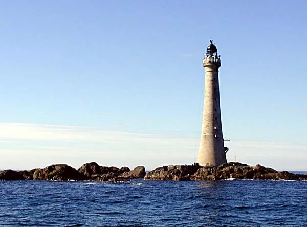
Skerryvore — remote reef off the west coast of Scotland, south-west of the island of Tiree.

Wikimedia Commons contributors — see linked file page for photographer and licence licence

Plan your visit
- Typical visit
- 4 h–12 h
- Free entry
- Dog-friendly
About
Skerryvore is a island in the United Kingdom. Part of Inner Hebrides. Wikidata describes it as: "remote reef off the west coast of Scotland, south-west of the island of Tiree". Coordinates: 56.3233°, -7.1150°.
Photo gallery
Official information
Skerryvore is associated with Ordnance Survey, which provides advanced mapping data for exploring and navigating Britain's landscape. Visitors can access a variety of maps and geographic information to enhance their outdoor experiences.
From the Wikipedia article
Skerryvore (from the Gaelic An Sgeir Mhòr meaning "The Great Skerry") is a remote island that lies off the west coast of Scotland, 11 nautical miles (20 kilometres) southwest of Tiree. Skerryvore Lighthouse is located on these rocks, built with some difficulty between 1838 and 1844 by Alan Stevenson. At a height of 156 feet (48 metres) it is the tallest lighthouse in Scotland. The shore station was at Hynish on Tiree (which now houses the Skerryvore Lighthouse Museum); operations were later transferred to Erraid, west of Mull. The remoteness of the location led to the keepers receiving additional payments in kind. The light shone without a break from 1844 until a fire in 1954 shut down operations for five years. The lighthouse was automated in 1994.
Excerpt from Wikipedia under CC BY-SA 4.0. See the source article linked in Sources below.
- Coordinates
- 56.3233, -7.1150
- Official site
- www.ordnancesurvey.co.uk
Sources
- wikidata: Q867300 (CC0)
- wikipedia: Skerryvore (CC BY-SA 4.0)
- commons: Skerryvore 01.jpg (CC BY-SA 4.0)
Other places nearby
Nearby
 📷 3
📷 3Lighthouses · Scottish Islands
Skerryvore Lighthouse
Skerryvore Lighthouse — lighthouse in Argyll and Bute, Scotland, UK.
 📷 5
📷 5Vineyards · Scottish Islands
Eilean Na Ba
Eilean Na Ba — a UK vineyard in scotland highlands, producing English or Welsh wine from cool-climate grape varieties.
 📷 3
📷 3Historic houses · Scottish Islands
St. Patrick's Temple
St. Patrick's Temple — a historic house in scotland-highlands, United Kingdom.
 📷 5
📷 5Vineyards · Scottish Islands
Dun Nan Gall
Dun Nan Gall — a UK vineyard in scotland highlands, producing English or Welsh wine from cool-climate grape varieties.
 📷 3
📷 3Hill forts · Scottish Islands
Dùn nan Gall, hill fort
Dùn nan Gall, hill fort — a hill fort in scotland-highlands, United Kingdom.
 📷 3
📷 3Where to eat & stay near Skerryvore
Places to stay
 📷 5
📷 5Campsites · Scottish Islands
Balinoe Campsite
Balinoe Campsite — a campsite in scotland highlands.
More places in this region
 📷 5
📷 5Islands · Scottish Islands
Bac Beag
Bac Beag — Scottish island, part of the Treshnish Isles in the Inner Hebrides.
 📷 5
📷 5Islands · Scottish Islands
Bac Mòr
Bac Mòr — island in Argyll and Bute, Scotland, UK, one of the Treshnish Isles.
 Flagship📷 3
Islands · Scottish Islands
Baleshare
Baleshare — flat tidal island in the Outer Hebrides, Scotland, UK.
 Flagship📷 5
Islands · Scottish Islands
Barra
Barra — island in Outer Hebrides, Scotland, UK.
Frequently asked questions
- Where is Skerryvore?
- Skerryvore is in the Scottish Islands, United Kingdom.
- What is Skerryvore?
- Skerryvore — remote reef off the west coast of Scotland, south-west of the island of Tiree.
- How do I get to Skerryvore?
- Its coordinates are 56.3233°, -7.1150°.
- Is Skerryvore free to visit?
- Yes, Skerryvore is free to enter.