
Reservoirs & lochs · Central Scotland
Shira Hydro-Electric Scheme
In or near Cairndow.
Shira Hydro-Electric Scheme in Scotland Islands, United Kingdom.

David P Howard — CC BY-SA 2.0 via Wikimedia Commons licence

Plan your visit
- Typical visit
- 1 h–2.5 h
- Free entry
- Dog-friendly
About
Shira Hydro-Electric Scheme is a place of interest in Scotland Islands, United Kingdom — drawn from open-data sources for visitor reference. See the linked Wikipedia article for the full description.
Photo gallery
From the Wikipedia article
The Shira Hydro-Electric Scheme is a project initiated by the North of Scotland Hydro-Electric Board to use the waters of the River Shira, the River Fyne and other small streams to generate hydroelectricity. It is located between Loch Fyne and Loch Awe in Argyll and Bute, western Scotland. It consists of three power stations and three impounding dams. The remoteness of the area in which the scheme was built required 15 miles (24 km) of access roads to be built before the main works could begin. The three dams were all of different types; a round headed buttress dam; a concrete gravity and earth fill dam; and the first ever use of a prestressed gravity dam. The construction of the earth fill dam was hindered by four months of extremely wet weather. Clachan was the first large underground power station that the Board built, while Sron Mor was the first implementation of a pumped storage scheme, built in anticipation of the arrival of nuclear power generation. The power stations were commissioned in 1953, 1955 and 1957, in advance of the completion of work on the dams.
Excerpt from Wikipedia under CC BY-SA 4.0. See the source article linked in Sources below.
Background
History
The North of Scotland Hydro-Electric Board was created by the Hydro-electric Development (Scotland) Act 1943, a measure championed by the politician Tom Johnston while he was Secretary of State for Scotland. Johnston's vision was for a public body that could build hydro-electric stations throughout the Highlands. Profits made by selling bulk electricity to the Scottish lowlands would be used to fund "the economic development and social improvement of the North of Scotland." Private consumers would be offered a supply of cheap electricity, and their connection to that supply would not reflect the actual cost of its provision in remote and sparsely populated areas. The first two major schemes…
Architecture
A main dam was built across the River Shira to create Lochan Shira, and another dam creating a second much smaller reservoir called Lochan Sron Mor was built below it. At the main dam site, the rock strata was quite variable, and 135000 cuyd of rock and soil were excavated before the foundations were put in. A round headed buttress dam was thought to be most suitable for the ground conditions after consideration of several other types. It was 2379 ft long and 148 ft high. The second dam was built in two parts, either side of a large rock intrusion. One half was a concrete gravity dam, and the other an earth fill dam with a central spine of concrete. Construction proceeded well until…
Sourced from Wikipedia under CC BY-SA 4.0.
- Coordinates
- 56.2776, -4.9220
- District
- Argyll and Bute
- Postcode
- PA26 8AB
- Parliamentary constituency
- Argyll, Bute and South Lochaber
Sources
- wikidata: Q121811880 (CC0)
- wikipedia: Shira Hydro-Electric Scheme (CC BY-SA 4.0)
Other places nearby

River Fyne Bridge, Cairndow
Historic bridges · 0.6 km

Achadunan Motte
Archaeological sites · 0.9 km

Cairndow War Memorial
Memorials & monuments · 2.1 km

Clachan Hill
Mountains & hills · 2.2 km
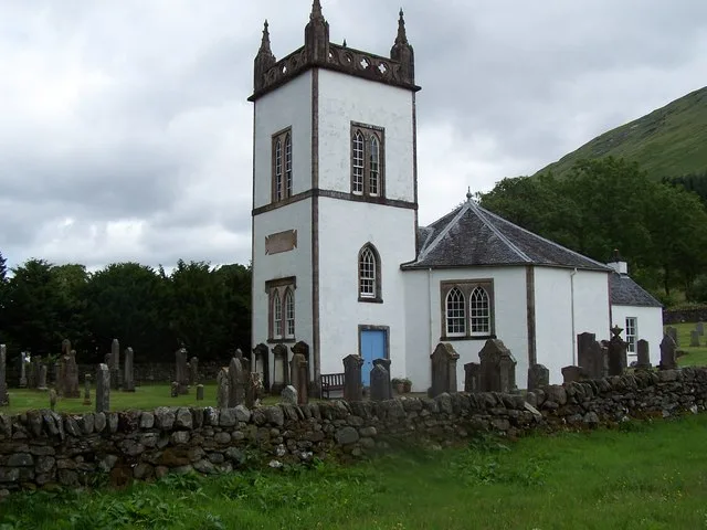
Kilmorich Parish Church
Historic churches · 2.8 km

Cairndow
Towns & cities · 2.9 km

Beinn Chas
Mountains & hills · 3.0 km

Eclectic Collection
Natural landmarks · 3.0 km
Sir John's Bank
Natural landmarks · 3.1 km

Pinetum
Natural landmarks · 3.3 km
Bodnant Bank
Natural landmarks · 3.3 km

Eagles fall
Waterfalls · 3.4 km
Nearby
📷 5Historic bridges · Central Scotland
River Fyne Bridge, Cairndow
River Fyne Bridge, Cairndow — category B listed building-listed bridge in scotland-highlands, United Kingdom.
📷 3Archaeological sites · Central Scotland
Achadunan Motte
Achadunan Motte — a archaeological in scotland-highlands, United Kingdom.
📷 3Memorials & monuments · Central Scotland
Cairndow War Memorial
Cairndow War Memorial — a memorial in scotland-highlands, United Kingdom.
📷 5Mountains & hills · Central Scotland
Clachan Hill
Clachan Hill — mountain in scotland highlands. Elevation: 658 m.
📷 3Historic churches · Central Scotland
Kilmorich Parish Church
Kilmorich Parish Church — church in Argyll and Bute, Scotland, UK.
📷 5Where to eat & stay near Shira Hydro-Electric Scheme
Places to stay
 📷 5
📷 5Caravan parks · Central Scotland
St Catherine's Caravan Park
St Catherine's Caravan Park — a caravan park in scotland highlands.
 📷 5
📷 5Hostels · Central Scotland
Inveraray Hostel
Inveraray Hostel — a hostel in scotland highlands.
 📷 5
📷 5Caravan parks · Central Scotland
Honeymoon Bridge
Honeymoon Bridge — a caravan park in scotland highlands.
 📷 5
📷 5Campsites · Central Scotland
Lochgoilhead Scout Camp
Lochgoilhead Scout Camp — a campsite in scotland highlands.
 📷 5
📷 5Caravan parks · Central Scotland
Lochgoilhead Holiday Park
Lochgoilhead Holiday Park — a caravan park in scotland highlands.
 📷 5
📷 5Caravan parks · Central Scotland
Stay the Night Ardgartan
Stay the Night Ardgartan — a caravan park in scotland highlands.
Places to eat & drink
 📷 5
📷 5Historic pubs · Central Scotland
The Drovers Inn
The Drovers Inn — Historic pub — listed building or notable heritage status.
 📷 3
📷 3Historic pubs · Central Scotland
Ardbrecknish House
Ardbrecknish House — Historic pub — listed building or notable heritage status.
More places in this region
 📷 5
📷 5 📷 3
📷 3Reservoirs & lochs · Central Scotland
Allt na Lairige Reservoir
Allt na Lairige Reservoir — 1956 artificial lake in Argyll and Bute, Scotland, UK, on and outflowing west to Allt na Lairige.
.jpg?width=1200) 📷 3
📷 3Reservoirs & lochs · Central Scotland
Ardlussa Fishing Loch
Ardlussa Fishing Loch — 1900 artificial lake on Jura, Argyll and Bute, Scotland, UK, on the Lussa River.
 📷 3
📷 3Reservoirs & lochs · Central Scotland
Asgog Loch
Asgog Loch — lake dammed as a reservoir in Argyll and Bute, Scotland, UK, outflows east via a watercourse to Allt Osda.
Frequently asked questions
- Where is Shira Hydro-Electric Scheme?
- Shira Hydro-Electric Scheme is in central Scotland, United Kingdom (postcode PA26 8AB).
- What is Shira Hydro-Electric Scheme?
- Shira Hydro-Electric Scheme in Scotland Islands, United Kingdom.
- How do I get to Shira Hydro-Electric Scheme?
- The nearest town is Cairndow. Drivers can use postcode PA26 8AB.
- Who owns Shira Hydro-Electric Scheme?
- Shira Hydro-Electric Scheme is owned by SSE.
- Is Shira Hydro-Electric Scheme free to visit?
- Yes, Shira Hydro-Electric Scheme is free to enter.
- How do I get to Shira Hydro-Electric Scheme?
- Drivers can navigate to postcode PA26 8AB. It sits within the Argyll, Bute and South Lochaber parliamentary constituency.