
Hostels · South West England
Sharon’s house
In or near Rodney Stoke.
Sharon’s house — a hostel in england south west.

b lewis — CC BY-SA 2.0 via Wikimedia Commons licence

Plan your visit
- Typical visit
- 1 h–2 h
About
Sharon’s house is a hostel located in england south west. Hostel listed with verified location and OSM metadata. Most British hostels offer dorm beds and private rooms; check current availability before arriving.
Photo gallery
Protected designations
- National Nature Reserve: MENDIP
- Area of Outstanding Natural Beauty: Mendip Hills
Designations sourced from Natural England open data under OGL v3.
Place summary
Sharon’s House is a hostel located in South-West England. It offers budget accommodation suitable for travellers seeking a simple and affordable stay. Visitors can expect a communal atmosphere and shared facilities, making it an ideal choice for those looking to meet fellow guests. The setting provides easy access to local attractions and the surrounding landscape.
AI-generated from the structured facts on this page (operator, designation, listing, era). Not a substitute for visiting.
- Coordinates
- 51.2556, -2.7541
- District
- Somerset
- Parish
- Rodney Stoke
- Postcode
- BS27 3TY
- Parliamentary constituency
- Wells and Mendip Hills
Sources
- osm: n5798833253 (ODbL)
Other places nearby

Draycott
Villages · 0.2 km
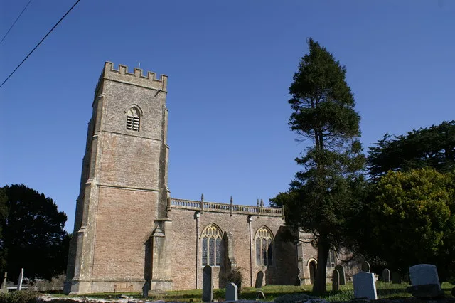
Church of St Leonard, Rodney Stoke
Historic churches · 1.4 km

Rodney Stoke
Towns & cities · 1.6 km

Cheddar Ales
Breweries · 1.6 km

Westbury Camp
Vineyards · 1.7 km

Nyland Hill
Mountains & hills · 1.8 km
Nyland Hill
Mountains & hills · 1.8 km

Petruth Paddocks
Campsites · 1.9 km

Bucklegrove Caravan Park
Caravan parks · 2.1 km

Cheddar Caravan and Motorhome Club Site
Caravan parks · 2.3 km
Cheddar Bridge Touring Park
Campsites · 2.4 km

Owley Woods Glamping
Campsites · 2.5 km
Nearby
📷 5📷 5Historic churches · South West England
Church of St Leonard, Rodney Stoke
Church of St Leonard, Rodney Stoke — church in Rodney Stoke, Somerset, England, UK.
📷 5Towns & cities · South West England
Rodney Stoke
Rodney Stoke — village and civil parish in Mendip, Somerset, England, United Kingdom.
📷 5Breweries · South West England
Cheddar Ales
Cheddar Ales — brewery in the village of Cheddar in Somerset, England.
📷 5Vineyards · South West England
Westbury Camp
Westbury Camp — a UK vineyard in england south west, producing English or Welsh wine from cool-climate grape varieties.
📷 5Mountains & hills · South West England
Nyland Hill
Nyland Hill — mountain in england south west. Elevation: 77 m.
Where to eat & stay near Sharon’s house
Places to stay
📷 4Campsites · South West England
Petruth Paddocks
Petruth Paddocks — a campsite in england south west.
📷 5Caravan parks · South West England
Bucklegrove Caravan Park
Bucklegrove Caravan Park — a caravan park in england south west.
📷 5Caravan parks · South West England
Cheddar Caravan and Motorhome Club Site
Cheddar Caravan and Motorhome Club Site — a caravan park in england south west.
📷 5Campsites · South West England
Cheddar Bridge Touring Park
Cheddar Bridge Touring Park — a campsite in england south west.
📷 5Campsites · South West England
Owley Woods Glamping
Owley Woods Glamping — a campsite in england south west.
 📷 5
Hostels · South West England
YHA Cheddar Youth Hostel
YHA Cheddar Youth Hostel — a hostel in england south west. Brand: Youth Hostels Association.
Places to eat & drink
 📷 5
Restaurants · South West England
Bekynton Brasserie
Bekynton Brasserie — a restaurant in england south west.
 📷 5
 📷 7
Historic pubs · South West England
The George & Pilgrim's Hotel
The George & Pilgrim's Hotel in England South West, United Kingdom.
 📷 7
Historic pubs · South West England
Rifleman's Arms Public House
Rifleman's Arms Public House in England South West, United Kingdom.
 📷 7
Historic pubs · South West England
The Bull Terrier
The Bull Terrier in England South West, United Kingdom.
 📷 7
Historic pubs · South West England
King William Inn
King William Inn in England South West, United Kingdom.
More places in this region
 📷 5
Hostels · South West England
Bath Backpackers
Bath Backpackers — a hostel in england south east.
 📷 5
 📷 5
Hostels · South West England
Young Men's Christian Association
Young Men's Christian Association — a hostel in england south east.
 📷 5
Hostels · South West England
YHA Lulworth Cove Youth Hostel
YHA Lulworth Cove Youth Hostel — a hostel in england south east. Brand: Youth Hostels Association.
Frequently asked questions
- Where is Sharon’s house?
- Sharon’s house is in South-West England, United Kingdom (postcode BS27 3TY), in the parish of Rodney Stoke.
- What is Sharon’s house?
- Sharon’s house — a hostel in england south west.
- How do I get to Sharon’s house?
- The nearest town is Rodney Stoke. Drivers can use postcode BS27 3TY.
- Is Sharon’s house a protected site?
- Yes — Sharon’s house is part of the MENDIP National Nature Reserve and the Mendip Hills National Landscape (AONB).
- How do I get to Sharon’s house?
- Drivers can navigate to postcode BS27 3TY. It sits within the Wells and Mendip Hills parliamentary constituency.