
Islands · Scottish Highlands
Sgeir Cùl an Rubha
Sgeir Cùl an Rubha — island in St Kilda, Outer Hebrides, Scotland, UK.

Wikimedia Commons contributors — see linked file page for photographer and licence licence

Plan your visit
- Typical visit
- 4 h–12 h
- Free entry
- Dog-friendly
About
Sgeir Cùl an Rubha is a island in the United Kingdom. Part of St Kilda. Wikidata describes it as: "island in St Kilda, Outer Hebrides, Scotland, UK". Coordinates: 57.7938°, -8.5612°.
Photo gallery
From the Wikipedia article
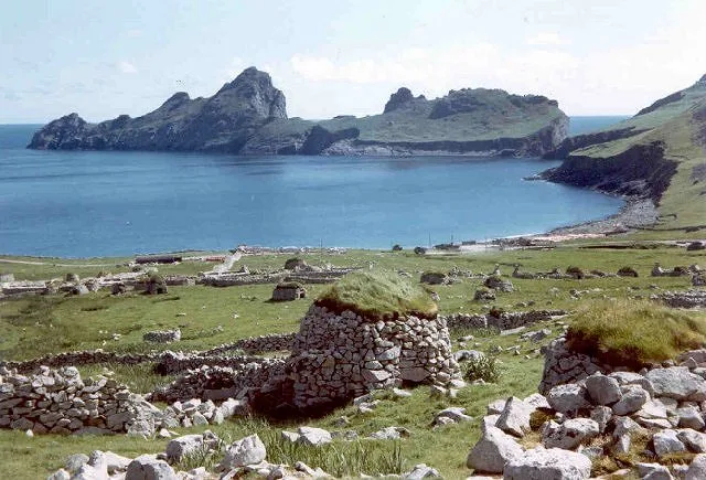
Sgeir Cùl an Rubha (Scottish Gaelic: "Skerry behind the headland") is an uninhabited islet in the St Kilda archipelago Outer Hebrides, Scotland. It is immediately south of Dùn, an island separated from Hirta by a narrow straight.
Excerpt from Wikipedia under CC BY-SA 4.0. See the source article linked in Sources below.
Background
History
]] The islet had always been seen as a hazard by St. Kildans, especially to vessels entering or exiting Village Bay or observing Dùn, which Sgeir Cùl an Rubha is directly adjacent to. The skerry is, while not completely submerged, hard to spot at high tide, as it lies very low in the water. As such, it is, and always has been, a danger to sailors. Therefore, the St. Kildans aptly named it the skerry behind the headland, which pinpointed its position through its name; therefore, vessels were aware of its position- behind the 'headland' (which Dùn closely resembled). Sgeir Cùl an Rubha was professionally unmapped underwater throughout much of the 20th century. It was an undived islet which…
Sourced from Wikipedia under CC BY-SA 4.0.
- Coordinates
- 57.7938, -8.5612
- Address
- St Kilda
Sources
- wikidata: Q56309184 (CC0)
- wikipedia: Sgeir Cùl an Rubha (CC BY-SA 4.0)
- commons: Sgeir Cul an Rubha - geograph.org.uk - 1444105.jpg (CC BY-SA 4.0)
Other places nearby
Loading nearby places…
Nearby
 Flagship📷 5
Islands · Scottish Highlands
Dùn
Dùn — island of St Kilda, Outer Hebrides, Scotland, UK.
 📷 3
📷 3Mountains & hills · Scottish Highlands
Loch Hirta
Loch Hirta — bay on the south-east of Hirta, St Kilda, Outer Hebrides, Scotland, UK.
 📷 3
📷 3Mountains & hills · Scottish Highlands
Oiseval
Oiseval — a mountain in scotland-highlands, United Kingdom.
 📷 3
📷 3Archaeological sites · Scottish Highlands
Lady Grange's Cleit
Lady Grange's Cleit — a archaeological in scotland-highlands, United Kingdom.
 📷 3
📷 3Museums · Scottish Highlands
Taigh-tasgaidh
Taigh-tasgaidh — a museum in scotland-highlands, United Kingdom.
 📷 3
📷 3Archaeological sites · Scottish Highlands
Taigh an t-Sithiche
Taigh an t-Sithiche — a archaeological in scotland-highlands, United Kingdom.
More places in this region
 📷 5
📷 5Islands · Scottish Highlands
Bac Beag
Bac Beag — Scottish island, part of the Treshnish Isles in the Inner Hebrides.
 📷 5
📷 5Islands · Scottish Highlands
Bac Mòr
Bac Mòr — island in Argyll and Bute, Scotland, UK, one of the Treshnish Isles.
 Flagship📷 3
Islands · Scottish Highlands
Baleshare
Baleshare — flat tidal island in the Outer Hebrides, Scotland, UK.
 Flagship📷 5
Islands · Scottish Highlands
Barra
Barra — island in Outer Hebrides, Scotland, UK.
Frequently asked questions
- Where is Sgeir Cùl an Rubha?
- Sgeir Cùl an Rubha is in Scottish Highlands, in the United Kingdom — coordinates 57.7938°, -8.5612°.
- Is Sgeir Cùl an Rubha free to visit?
- Yes — admission to Sgeir Cùl an Rubha is free.