Mountains & hills · Scottish Highlands
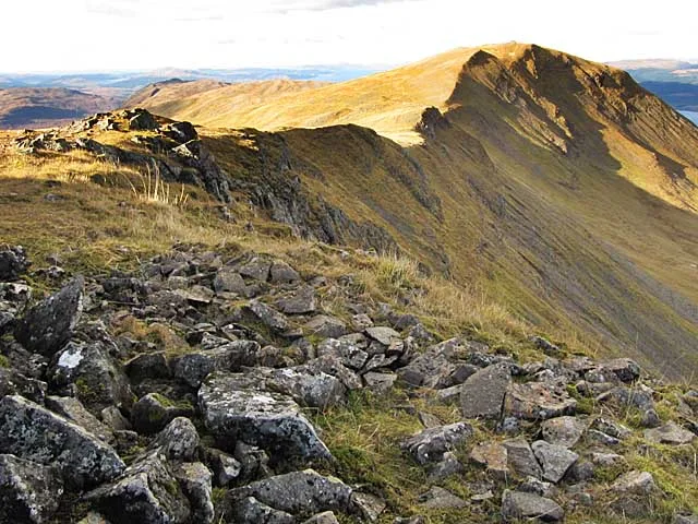
Sgùrr Dearg
Sgùrr Dearg — mountain in scotland highlands. Elevation: 741 m.

Trevor Littlewood — CC BY-SA 2.0 via Wikimedia Commons licence
Plan your visit
- Typical visit
- 3 h–8 h
- Best time of year
- Late spring – early autumn (May–Oct)
About
Sgùrr Dearg is a mountain located in scotland highlands. Elevation: 741 m. A named British peak recorded in OpenStreetMap. Peaks are typically named on Ordnance Survey 1:50k mapping.
Photo gallery
Place summary
Sgùrr Dearg is a mountain located in the Scottish Highlands. It is known for its distinctive red quartzite summit, which rises prominently in the landscape. The mountain is part of the Cuillin range on the Isle of Skye, attracting climbers and hikers with its challenging terrain and striking views. The area offers various walking trails for different skill levels, making it a notable destination for outdoor enthusiasts.
AI-generated from the structured facts on this page (operator, designation, listing, era). Not a substitute for visiting.
- Coordinates
- 56.4402, -5.7900
Sources
- osm: n2702943801 (ODbL)
- wikidata: Q20735458 (CC0)
Other places nearby
Loading nearby places…
Nearby
📷 5Mountains & hills · Scottish Highlands
Sgurr Dearg
Sgurr Dearg — a hill or mountain in scotland highlands.
📷 5Mountains & hills · Scottish Highlands
Beinn Bhearnach
Beinn Bhearnach — mountain in scotland highlands. Elevation: 633 m.
 📷 3
📷 3Mountains & hills · Scottish Highlands
Mainnir nam Fiadh
Mainnir nam Fiadh — a mountain in scotland-highlands, United Kingdom.
 📷 3
📷 3Natural landmarks · Scottish Highlands
Dùn da Ghaoithe
Dùn da Ghaoithe — 766m high mountain in Argyll and Bute, Scotland, UK.
 📷 5
📷 5Mountains & hills · Scottish Highlands
Dun da Ghaoithe
Dun da Ghaoithe — a hill or mountain in scotland highlands.
 📷 3
📷 3Mountains & hills · Scottish Highlands
Dùn da Ghaoithe
Dùn da Ghaoithe — Named summit at 766 m.
Where to eat & stay near Sgùrr Dearg
Places to stay
 📷 5
📷 5Hostels · Scottish Highlands
Craignure Bunkhouse
Craignure Bunkhouse — a hostel in scotland highlands.
 📷 5
📷 5Campsites · Scottish Highlands
Shieling Holidays
Shieling Holidays — a campsite in scotland highlands.
 📷 5
📷 5Hostels · Scottish Highlands
Highland Basecamp
Highland Basecamp — a hostel in scotland highlands.
 📷 5
📷 5Campsites · Scottish Highlands
Salen Bay Campsite
Salen Bay Campsite — a campsite in scotland highlands.
 📷 5
📷 5Campsites · Scottish Highlands
Killiechronan Campsite
Killiechronan Campsite — a campsite in scotland highlands.
 📷 5
📷 5Campsites · Scottish Highlands
Port nan Gael
Port nan Gael — a campsite in scotland highlands.
Places to eat & drink
 📷 3
📷 3Historic pubs · Scottish Highlands
Tigh an Truish Inn
Tigh an Truish Inn — Historic pub — listed building or notable heritage status.
 📷 5
📷 5Historic pubs · Central Scotland
Oban Inn
Oban Inn in Scotland Central, United Kingdom.
 📷 5
📷 5Historic pubs · Central Scotland
Caledonian Hotel, George Street, Oban
Caledonian Hotel, George Street, Oban in Scotland Central, United Kingdom.
 📷 5
📷 5Historic pubs · Central Scotland
King's Arms Flats, 28 George Street, Oban
King's Arms Flats, 28 George Street, Oban in Scotland Central, United Kingdom.
 📷 5
📷 5Restaurants · Scottish Highlands
The Boathouse
The Boathouse — a restaurant in scotland highlands.
More mountains in this region
 📷 3
📷 3Mountains & hills · Scottish Highlands
A' Bhuidheanach Bheag
A' Bhuidheanach Bheag — Named summit at 936 m.
 📷 3
📷 3Mountains & hills · Scottish Highlands
A' Chailleach
A' Chailleach — Named summit at 997 m.
 📷 3
📷 3Mountains & hills · Scottish Highlands
A' Chailleach
A' Chailleach — Named summit at 930 m.
 📷 3
📷 3Mountains & hills · Scottish Highlands
A' Chaoirnich
A' Chaoirnich — Named summit at 875 m.
Frequently asked questions
- Where is Sgùrr Dearg?
- Sgùrr Dearg is in the Scottish Highlands, United Kingdom.
- What is Sgùrr Dearg?
- Sgùrr Dearg — mountain in scotland highlands. Elevation: 741 m.
- How do I get to Sgùrr Dearg?
- Its coordinates are 56.4402°, -5.7900°.