
Chapels · London
Ruislip
In or near Denham.
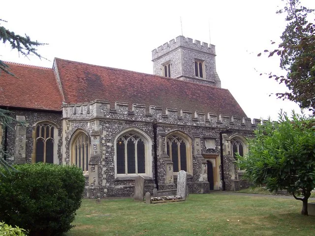
Ruislip — a methodist chapel in england-london, United Kingdom.

Stefan Czapski — CC BY-SA 2.0 via Wikimedia Commons licence

Plan your visit
- Typical visit
- 20 min–45 min
- Nearest railway station
- West Ruislip · 0.8 km
- Free entry
About
Ruislip is a methodist chapel located in england-london, United Kingdom. Catalogued from Wikidata's UK heritage register; see the linked Wikipedia article for further details on its history, architecture and visiting information.
Photo gallery
Protected designations
- Area of Outstanding Natural Beauty: Chilterns
Designations sourced from Natural England open data under OGL v3.
Place summary
Ruislip is a chapel located in the London region. It is notable for its historical significance and architectural features, contributing to the area's cultural heritage.
AI-generated from the structured facts on this page (operator, designation, listing, era). Not a substitute for visiting.
Background
Visiting
Ruislip was the setting for the 1967 film Poor Cow. In one scene, a title card states "When Tom was in the money, the world was our oyster, and we chose Ruislip" before cutting to an aerial view of a large council estate. The now demolished Punch and Judy cafe on Ducks Hill Road was the location for Dave Allen's bank note under a car sketch. Alvin Stardust filmed a Green Cross Code advert on Ruislip High Street. This safety film dates from circa 1976. The children's TV programme Come Outside features Ruislip Manor library in the edition called Buses. Episode 7 of series 7 of The Two Ronnies featured a sketch titled "Home Rule for Ruislip". The sketch features Ronnie Barker dressed as a…
Sourced from Wikipedia under CC BY-SA 4.0.
- Coordinates
- 51.5760, -0.4330
- District
- Hillingdon
- Parish
- Hillingdon, unparished area
- Postcode
- HA4 7LD
- Parliamentary constituency
- Ruislip, Northwood and Pinner
- Nearest railway station
- West Ruislip — 0.8 km
- Official site
- data.london.gov.uk
Sources
Other places nearby

Manor Farm, Ruislip
Castles · 0.4 km
Cow Byre Gallery
Galleries · 0.4 km

Winston Churchilll Hall
Theatres · 0.4 km

Ruislip Manor Farm
Castles · 0.5 km

The White Bear
Restaurants · 0.5 km
Pram Shed
Museums · 0.5 km
St Martin's Church, Ruislip
Historic churches · 0.5 km
Manor Farm Complex
Museums · 0.5 km
Manor Farm House
Museums · 0.5 km

Monument to Annie Hall northeast of war memorial and behind Number 39 in St Martin's Churchyard
Public art & sculpture · 0.5 km

Ruislip tube station
Historic houses · 1.0 km

The Barn Hotel
Hotels · 1.0 km
Nearby
📷 5Castles · London
Manor Farm, Ruislip
Manor Farm is a 22-acre (8.9 ha) historic site in Ruislip, Greater London. It incorporates a medieval farm complex, with a main old barn dating from the 13th century and a farm house from the 16th. N
📷 5Galleries · London
Cow Byre Gallery
Cow Byre Gallery — a gallery in england-london, United Kingdom.
📷 5Theatres · London
Winston Churchilll Hall
Winston Churchilll Hall is a theatre in the United Kingdom.
📷 5📷 7Restaurants · London
The White Bear
The White Bear — a restaurant in england london.
📷 5Museums · London
Pram Shed
Pram Shed — a museum in england-london, United Kingdom.
Where to eat & stay near Ruislip
Places to stay
📷 5 📷 5
📷 5 📷 5
📷 5 📷 5
📷 5Caravan parks · London
Wyatt's Covert Caravan Site
Wyatt's Covert Caravan Site — a caravan park in england london.
 📷 5
📷 5 📷 5
📷 5Places to eat & drink
📷 7Restaurants · London
The White Bear
The White Bear — a restaurant in england london.
 📷 5
📷 5 📷 5
📷 5 📷 5
📷 5 📷 5
📷 5Historic pubs · London
The Hand In Hand Public House
The Hand In Hand Public House in England London, United Kingdom.
 📷 5
📷 5More places in this region
.jpg?width=1200) 📷 5
📷 5Chapels · London
Baptist Chapel
Baptist Chapel — chapel in Southwark, London, England, UK.
 📷 5
📷 5Chapels · London
Boone's Chapel
Boone's Chapel — Grade I listed chapel in London Borough of Lewisham, United Kingdom.
 📷 5
📷 5Chapels · London
Chantry Chapel Of St Mary Magdalene
Chantry Chapel Of St Mary Magdalene — chapel in Royal Borough of Kingston upon Thames, London, England, UK.
 📷 5
📷 5Chapels · London
Chapel at College of St Mark and St John
Chapel at College of St Mark and St John — grade II listed chapel in the United Kingdom.
Frequently asked questions
- Where is Ruislip?
- Ruislip is in London, United Kingdom (postcode HA4 7LD), in the parish of Hillingdon, unparished area.
- What is Ruislip?
- Ruislip — a methodist chapel in england-london, United Kingdom.
- How do I get to Ruislip?
- The nearest railway station is West Ruislip, about 0.8 km away. Drivers can use postcode HA4 7LD.
- Is Ruislip a protected site?
- Yes — Ruislip is part of the Chilterns National Landscape (AONB).
- Is Ruislip free to visit?
- Yes, Ruislip is free to enter.
- How do I get to Ruislip?
- The nearest railway station is West Ruislip, about 0.8 km away. Drivers can navigate to postcode HA4 7LD.