Mountains & hills · Scottish Highlands
Ruadh Stac Beag
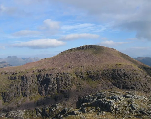
Ruadh Stac Beag — a hill or mountain in scotland highlands.

Stuart Meek — CC BY-SA 2.0 via Wikimedia Commons licence
Plan your visit
- Typical visit
- 3 h–8 h
- Best time of year
- Late spring – early autumn (May–Oct)
About
A British hill or mountain, named on Ordnance Survey maps and walked by hill-baggers. Ruadh Stac Beag is a named hill or mountain in scotland highlands, recorded in the GeoNames UK gazetteer. British landmarks of this type are typically marked on Ordnance Survey maps and recorded in the national gazetteer for cartographic and navigational reference. Coordinates and feature classification are sourced from the GeoNames open dataset.
Photo gallery
Place summary
Ruadh Stac Beag is a mountain located in the Scottish Highlands. It is part of the Fannichs range, known for its rugged terrain and scenic vistas. The mountain offers a challenging ascent and is popular among experienced hikers and climbers. The surrounding area features a mix of glens and lochs, providing a striking backdrop for outdoor activities.
AI-generated from the structured facts on this page (operator, designation, listing, era). Not a substitute for visiting.
- Coordinates
- 57.7404, -5.3167
Sources
- manual: geonames-12614025 (CC BY 4.0)
Other places nearby
Loading nearby places…
Nearby
📷 5Mountains & hills · Scottish Highlands
Ruadh-stac Beag
Ruadh-stac Beag — mountain in scotland highlands. Elevation: 711 m.
 📷 3
📷 3Mountains & hills · Scottish Highlands
Ruadh Stac Beag South Top
Ruadh Stac Beag South Top — a mountain in scotland-highlands, United Kingdom.
📷 5Mountains & hills · Scottish Highlands
Creag Mhor a' Bhinnein
Creag Mhor a' Bhinnein — a hill or mountain in scotland highlands.
 📷 3
📷 3Mountains & hills · Scottish Highlands
Ruadh-stac Mòr
Ruadh-stac Mòr — Named summit at 918 m.
 📷 5
📷 5Mountains & hills · Scottish Highlands
Ruadh Stac Mor
Ruadh Stac Mor — a hill or mountain in scotland highlands.
 📷 5
📷 5Gorges · Scottish Highlands
Gleann na Muice
Gleann na Muice — a gorge in scotland highlands.
Where to eat & stay near Ruadh Stac Beag
Places to stay
 📷 5
📷 5Hostels · Scottish Highlands
Sail Mhor Croft Hostel
Sail Mhor Croft Hostel — a hostel in scotland highlands.
 📷 5
📷 5Campsites · Scottish Highlands
Beinn Eighe Campsite
Beinn Eighe Campsite — a campsite in scotland highlands.
 📷 5
📷 5Campsites · Scottish Highlands
Northern Lights Camping & Caravan Park
Northern Lights Camping & Caravan Park — a campsite in scotland highlands.
 📷 5
📷 5Campsites · Scottish Highlands
Badrallach Campsite
Badrallach Campsite — a campsite in scotland highlands.
 📷 5
📷 5Caravan parks · Scottish Highlands
Kinlochewe Caravan Club Site
Kinlochewe Caravan Club Site — a caravan park in scotland highlands.
 📷 5
📷 5Hostels · Scottish Highlands
Kinlochewe Bunkhouse
Kinlochewe Bunkhouse — a hostel in scotland highlands.
More mountains in this region
 📷 3
📷 3Mountains & hills · Scottish Highlands
A' Bhuidheanach Bheag
A' Bhuidheanach Bheag — Named summit at 936 m.
 📷 3
📷 3Mountains & hills · Scottish Highlands
A' Chailleach
A' Chailleach — Named summit at 997 m.
 📷 3
📷 3Mountains & hills · Scottish Highlands
A' Chailleach
A' Chailleach — Named summit at 930 m.
 📷 3
📷 3Mountains & hills · Scottish Highlands
A' Chaoirnich
A' Chaoirnich — Named summit at 875 m.
Frequently asked questions
- Where is Ruadh Stac Beag?
- Ruadh Stac Beag is in the Scottish Highlands, United Kingdom.
- What is Ruadh Stac Beag?
- Ruadh Stac Beag — a hill or mountain in scotland highlands.
- How do I get to Ruadh Stac Beag?
- Its coordinates are 57.7404°, -5.3167°.