Mountains & hills · Mid Wales
Roundton Hill
In or near Priestweston.
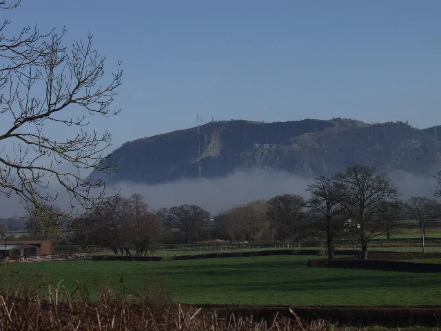
Roundton Hill — Named summit at 371 m.

Wikimedia Commons contributors — see linked file page for photographer and licence licence
Plan your visit
- Typical visit
- 3 h–8 h
- Best time of year
- Late spring – early autumn (May–Oct)
- Free entry
- Dog-friendly
About
Roundton Hill is a named summit in the United Kingdom. Wikidata describes it as: "Named summit at 371 m.". Coordinates: 52.5477°, -3.0426°.
Photo gallery
Official information
Roundton Hill Nature Reserve is a wildlife-rich area featuring an Iron Age hillfort and diverse habitats. Visitors can enjoy spectacular views, various walking trails, and observe a wide range of flora and fauna, including rare species. The reserve is particularly vibrant in spring and summer with colorful wildflowers and active birdlife.
Protected designations
- Area of Outstanding Natural Beauty: Shropshire Hills
Designations sourced from Natural England open data under OGL v3.
From the Wikipedia article
Roundton Hill is a rounded, steep sided, 1,210 feet (370 m) hill, volcanic in origin, in the easternmost part of old Montgomeryshire (in present day-Powys), Wales, which juts into the English border near Church Stoke. It is managed as a nature reserve by the Montgomeryshire Wildlife Trust, who acquired it in 1985.
Excerpt from Wikipedia under CC BY-SA 4.0. See the source article linked in Sources below.
- Coordinates
- 52.5477, -3.0426
- District
- Powys
- Parish
- Churchstoke
- Postcode
- SY15 6EL
- Parliamentary constituency
- Montgomeryshire and Glyndwr
- Phone
- 01938 555654
- Opening
- Open at all times
- Official site
- www.montwt.co.uk
Sources
- osm: n3961320855 (ODbL)
- wikipedia: Roundton Hill (CC BY-SA 4.0)
- commons: Roundton Hill - geograph.org.uk - 719042.jpg (CC BY-SA 4.0)
Other places nearby

Roundton Hill
Vineyards · 0.0 km

Castle Ring, Old Churchstoke
Vineyards · 0.5 km
Old Church Stoke Castle Ring
Literary houses · 0.5 km

Roundton
Mountains & hills · 0.5 km

Todleth Hill
Mountains & hills · 0.7 km
Todleth Hill
Mountains & hills · 0.7 km

Old Church Stoke
Historic churches · 0.8 km

Upper Aldress Moated Site
Literary houses · 1.2 km

Simons Castle
Castles · 1.8 km

Simon's Castle
Literary houses · 1.8 km

Lan Fawr
Mountains & hills · 1.9 km

Hyssington Castle
Literary houses · 2.1 km
Nearby
📷 5Vineyards · Mid Wales
Roundton Hill
Roundton Hill — a UK vineyard in wales mid, producing English or Welsh wine from cool-climate grape varieties.
📷 5Vineyards · Mid Wales
Castle Ring, Old Churchstoke
Castle Ring, Old Churchstoke — a UK vineyard in wales mid, producing English or Welsh wine from cool-climate grape varieties.
📷 5Literary houses · Mid Wales
Old Church Stoke Castle Ring
Old Church Stoke Castle Ring — a literary house museum in wales mid.
📷 5📷 5📷 5Where to eat & stay near Roundton Hill
Places to stay
 📷 5
📷 5Caravan parks · Mid Wales
Daisy Bank Touring Caravan Park
Daisy Bank Touring Caravan Park — a caravan park in wales mid.
 📷 5
📷 5Caravan parks · Mid Wales
Runnis Meadow Campsite
Runnis Meadow Campsite — a caravan park in wales mid.
 📷 5
📷 5 📷 5
📷 5 📷 5
📷 5Campsites · Mid Wales
Foxholes Camp Site
Foxholes Camp Site — a campsite in wales mid.
 📷 5
📷 5Places to eat & drink
 📷 7
📷 7 📷 5
📷 5Historic pubs · Mid Wales
The Black Lion And Forecourt Railings
The Black Lion And Forecourt Railings in Wales Mid, United Kingdom.
 📷 7
📷 7Historic pubs · Mid Wales
The Six Bells And Former Stables To Rear
The Six Bells And Former Stables To Rear in Wales Mid, United Kingdom.
 📷 4
📷 4Historic pubs · Mid Wales
The Checkers
The Checkers in Wales Mid, United Kingdom.
 📷 7
📷 7 📷 5
📷 5More mountains in this region
 📷 3
📷 3 📷 3
📷 3 📷 3
📷 3 📷 3
📷 3Frequently asked questions
- Where is Roundton Hill?
- Roundton Hill is in Mid Wales, United Kingdom (postcode SY15 6EL), in the parish of Churchstoke.
- What is Roundton Hill?
- Roundton Hill — Named summit at 371 m.
- How do I get to Roundton Hill?
- Drivers can use postcode SY15 6EL.
- Who owns Roundton Hill?
- Roundton Hill is owned by Montgomeryshire Wildlife Trust.
- Is Roundton Hill a protected site?
- Yes — Roundton Hill is part of the Shropshire Hills National Landscape (AONB).
- Is Roundton Hill free to visit?
- Yes, Roundton Hill is free to enter.
- How do I get to Roundton Hill?
- Drivers can navigate to postcode SY15 6EL. It sits within the Montgomeryshire and Glyndwr parliamentary constituency.