
Archaeological sites · South West England
Round, courtyard house, stone hut circle settlement and field system 275m north of Castallack Carn
In or near Lamorna.
Round, courtyard house, stone hut circle settlement and field system 275m north of Castallack Carn — archaeological site in Cornwall, England, UK.

Wikimedia Commons contributors — see linked file page for photographer and licence licence

Plan your visit
- Typical visit
- 45 min–1.5 h
- Nearest railway station
- Penzance · 6.0 km
- Free entry
- Dog-friendly
Getting there & planning your visit
To visit the Round, courtyard house, stone hut circle settlement and field system, the nearest railway station is Penzance, located 6 km away. The postcode for sat-nav is TR19 6NX, and entry is free.
About
Round, courtyard house, stone hut circle settlement and field system 275m north of Castallack Carn is an archaeological site in the United Kingdom. Heritage designation: scheduled monument. Wikidata describes it as: "archaeological site in Cornwall, England, UK". Coordinates: 50.0741°, -5.5687°.
Photo gallery
Protected designations
- Area of Outstanding Natural Beauty: Cornwall
Designations sourced from Natural England open data under OGL v3.
From the Wikipedia article
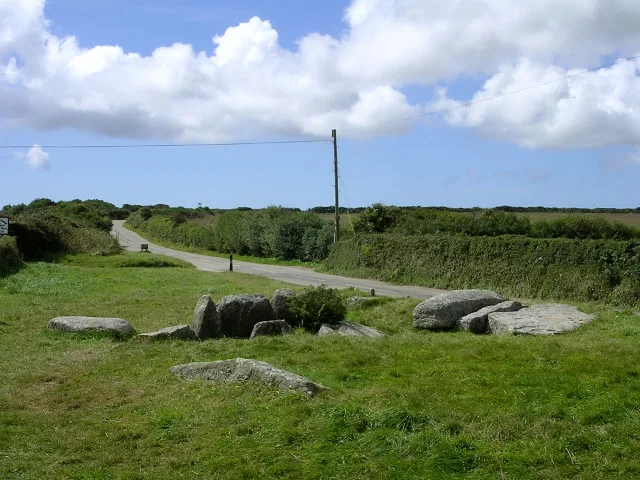
Castallack Round or Roundago is a prehistoric site near Castallack in Cornwall, England. It is a scheduled monument. A "round" is a small circular embanked enclosure, with one entrance; they are common in Cornwall, and they date from the late Iron Age to the early post-Roman period.
Excerpt from Wikipedia under CC BY-SA 4.0. See the source article linked in Sources below.
Background
Description
The site is near the summit of a ridge overlooking the Lamorna valley. Part of the rampart survives; it is composed of large stones and slabs, height about 1.6 m and width 1.8 m, forming an oval enclosure. There was originally a surrounding ditch. On the tithe map of 1840, the round is depicted as having a colonnade of stones leading from the entrance in the south to an inner circular enclosure; John Thomas Blight, describing it in 1865, found that these features had mostly disappeared. To the north-west of the round there are thick stone walls, height up to 0.9 m: the remains of a structure with an internal diameter of about 7.5 m. This is interpreted as a courtyard house, a type of…
Sourced from Wikipedia under CC BY-SA 4.0.
- Coordinates
- 50.0741, -5.5687
- District
- Cornwall
- Parish
- St. Buryan, Lamorna and Paul
- Postcode
- TR19 6NX
- Parliamentary constituency
- St Ives
- Nearest railway station
- Penzance — 6 km
Sources
- wikidata: Q17642717 (CC0)
- wikipedia: Castallack Round (CC BY-SA 4.0)
- commons: The Round at Castallack Round - geograph.org.uk - 974875.jpg (CC BY-SA 4.0)
Other places nearby

Lamorna
Towns & cities · 1.3 km

Boleigh Farm Campsite
Campsites · 1.3 km

Chygurno
Natural landmarks · 1.3 km

The Pipers
Natural landmarks · 1.3 km
The Pipers
Archaeological sites · 1.3 km

Quay At Sw450240
Marinas · 1.4 km

The Merry Maidens Stone Circle
Archaeological sites · 1.7 km

Kerris Cross
Historic houses · 1.8 km
Tregiffian Burial Chamber
Hill forts · 1.9 km

Prehistoric entrance grave 900m north west of Tregiffian Farm
Archaeological sites · 2.0 km

Gûn Rith Menhir
Archaeological sites · 2.0 km

Standing stone 335m west of the Merry Maidens Stone Circle
Windmills · 2.0 km
Nearby
📷 5Towns & cities · South West England
Lamorna
Lamorna — village in the parish of St Buryan, Lamorna and Paul, Cornwall.
📷 5Campsites · South West England
Boleigh Farm Campsite
Boleigh Farm Campsite — a campsite in england south west.
📷 3Natural landmarks · South West England
Chygurno
Chygurno — a place in South West England, United Kingdom.
📷 3Natural landmarks · South West England
The Pipers
The Pipers — a place in South West England, United Kingdom.
📷 5Archaeological sites · South West England
The Pipers
The Pipers — archaeological in england south west.
📷 5Where to eat & stay near Round, courtyard house, stone hut circle settlement and field system 275m north of Castallack Carn
Places to stay
📷 5Campsites · South West England
Boleigh Farm Campsite
Boleigh Farm Campsite — a campsite in england south west.
 📷 5
📷 5Campsites · South West England
Mousehole Camping
Mousehole Camping — a campsite in england south west.
 📷 6
📷 6B&Bs · South West England
The Ship Inn
The Ship Inn — a bed-and-breakfast in england south west.
 📷 5
📷 5Caravan parks · South West England
Penlee Caravan Park
Penlee Caravan Park — a caravan park in england south west.
 📷 5
📷 5Campsites · South West England
St Loy's Camp Site
St Loy's Camp Site — a campsite in england south west.
 📷 5
📷 5Campsites · South West England
Treverven Touring Park
Treverven Touring Park — a campsite in england south west.
Places to eat & drink
 📷 5
📷 5Historic pubs · South West England
Tolcarne Inn Public House
Tolcarne Inn Public House in England South West, United Kingdom.
 📷 5
📷 5Historic pubs · South West England
First And Last Inn
First And Last Inn in England South West, United Kingdom.
 📷 7
📷 7Restaurants · South West England
The Old Lifeboat House Bistro
The Old Lifeboat House Bistro — a restaurant in england south west. Cuisine: seafood.
 📷 5
📷 5 📷 5
📷 5Historic pubs · South West England
The Sloop Inn
The Sloop Inn in England South West, United Kingdom.
 📷 5
📷 5Historic pubs · South West England
The Bucket of Blood
The Bucket of Blood in England South West, United Kingdom.
More archaeological sites in this region
 📷 5
📷 5Archaeological sites · South West England
Battlesbury Camp Monuments: hillfort, settlement, cemetery, barrows, enclosure, and field systems
Battlesbury Camp Monuments: hillfort, settlement, cemetery, barrows, enclosure, and field systems — archaeological site in Warminster, Wiltshire, England, UK.
 📷 5
📷 5Archaeological sites · South West England
Blandford Forest
Blandford Forest — forest in Blandford Forum, England.
 📷 5
📷 5Archaeological sites · South West England
Boulsbury Wood
Boulsbury Wood — protected area in Dorset and Hampshire, England.
.jpg?width=1200) 📷 5
📷 5Archaeological sites · South West England
Cranborne Chase
Cranborne Chase — Plateau in southern England.
Frequently asked questions
- Where is Round, courtyard house, stone hut circle settlement and field system 275m north of Castallack Carn?
- Round, courtyard house, stone hut circle settlement and field system 275m north of Castallack Carn is in South-West England, United Kingdom (postcode TR19 6NX), in the parish of St. Buryan, Lamorna and Paul.
- What is Round, courtyard house, stone hut circle settlement and field system 275m north of Castallack Carn?
- Round, courtyard house, stone hut circle settlement and field system 275m north of Castallack Carn — archaeological site in Cornwall, England, UK.
- How do I get to Round, courtyard house, stone hut circle settlement and field system 275m north of Castallack Carn?
- The nearest railway station is Penzance, about 6.0 km away. The nearest town is Lamorna. Drivers can use postcode TR19 6NX.
- Is Round, courtyard house, stone hut circle settlement and field system 275m north of Castallack Carn a listed building?
- Round, courtyard house, stone hut circle settlement and field system 275m north of Castallack Carn is officially recognised as scheduled monument listed.
- Is Round, courtyard house, stone hut circle settlement and field system 275m north of Castallack Carn a protected site?
- Yes — Round, courtyard house, stone hut circle settlement and field system 275m north of Castallack Carn is part of the Cornwall National Landscape (AONB).
- Is Round, courtyard house, stone hut circle settlement and field system 275m north of Castallack Carn free to visit?
- Yes, Round, courtyard house, stone hut circle settlement and field system 275m north of Castallack Carn is free to enter.
- How do I get to Round, courtyard house, stone hut circle settlement and field system 275m north of Castallack Carn?
- The nearest railway station is Penzance, about 6.0 km away. Drivers can navigate to postcode TR19 6NX.