
Forests & woodlands · East of England
Roswell Pits
In or near Ely.
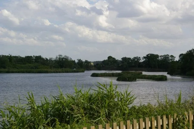
Roswell Pits is a forest or woodland in the United Kingdom.

Wikimedia Commons contributors — see linked file page for photographer and licence licence

Plan your visit
- Typical visit
- 1 h–3 h
- Nearest railway station
- Ely · 1.7 km
- Free entry
- Family-friendly
- Dog-friendly
Getting there & planning your visit
To visit Roswell Pits, the nearest railway station is Ely, located 1.7 km away. The postcode for sat-nav is CB7 4TX, and entry is free.
About
Roswell Pits is a named forest, woodland or nature reserve in the United Kingdom. Coordinates: 52.4029°, 0.2820°. This entry is part of The Great Britain Guide, a free, ad-free, open-data tourist directory.
Photo gallery
Protected designations
- Site of Special Scientific Interest: Ouse Washes SSSI
- Site of Special Scientific Interest: Ely Pits and Meadows SSSI
- Ramsar wetland: Ouse Washes
Designations sourced from Natural England open data under OGL v3.
From the Wikipedia article
Roswell Pits is a 20 acre nature reserve on the eastern outskirts of Ely in Cambridgeshire. It is managed by the Environment Agency. It is part of the Ely Pits and Meadows Site of Special Scientific Interest (SSSI)) and Geological Conservation Review site. The SSSI designation for both biological and geological interest. The site was formerly managed by the Wildlife Trust for Bedfordshire, Cambridgeshire and Northamptonshire.
Excerpt from Wikipedia under CC BY-SA 4.0. See the source article linked in Sources below.
Background
History
The pits were a source of gault, an impervious clay used to maintain river banks in the low-lying regions of the South Level of the Fens. Following the re-routing of the rivers in the region by Cornelius Vermuyden and his Adventurers in the 1650s, to more effectively drain the Fens, the peaty soils began to dry out and shrink. As the land surface sunk below the levels of the rivers, it became important to maintain the banks with something impervious to water, to prevent seepage into the newly drained agricultural land, and to prevent collapse of the banks and flooding of the land in times of heavy rainfall. Roswell Pits were an ideal source of this material, as they were located adjacent to…
Sourced from Wikipedia under CC BY-SA 4.0.
- Coordinates
- 52.4029, 0.2820
- County
- Cambridgeshire
- District
- East Cambridgeshire
- Parish
- Ely
- Postcode
- CB7 4TX
- Parliamentary constituency
- Ely and East Cambridgeshire
- Nearest railway station
- Ely — 1.7 km
Sources
- osm: w48068323 (ODbL)
- wikipedia: Roswell Pits (CC BY-SA 4.0)
- commons: Roswell Pits.jpg (CC BY-SA 4.0)
Other places nearby
Roswell Pits
Wildlife reserves · 0.2 km

Mill Mound
Mountains & hills · 0.5 km

New Connexions Free Church Ely
Historic churches · 0.8 km

Majestic Theatre
Theatres · 1.0 km

Babylon ARTS
Galleries · 1.1 km

Royal Standard Public House
Historic pubs · 1.1 km

Ely Markets
Farmers’ markets · 1.1 km

Wall to the garden of The Almonry and Painted Chamber
Holy wells · 1.2 km

Ely Islamic Centre
Historic churches · 1.2 km

Ely Cinema
Theatres · 1.2 km
%2C_Ely.jpg?width=1200)
The Chapel of the Infirmary (deanery)
Chapels · 1.3 km

The Chapel of the Infirmary (deanery)
Chapels · 1.3 km
Nearby
📷 5Wildlife reserves · East of England
Roswell Pits
Roswell Pits — nature reserve in the United Kingdom.
📷 5Mountains & hills · East of England
Mill Mound
Mill Mound — mountain in england london. Elevation: 24 m.
📷 5Historic churches · East of England
New Connexions Free Church Ely
New Connexions Free Church Ely — church in Cambridgeshire, United Kingdom.
📷 3Theatres · East of England
Majestic Theatre
Majestic Theatre in England East, United Kingdom.
📷 5Galleries · East of England
Babylon ARTS
Babylon ARTS — a gallery in East of England, United Kingdom.
📷 7Historic pubs · East of England
Royal Standard Public House
Royal Standard Public House in England East, United Kingdom.
Where to eat & stay near Roswell Pits
Places to stay
 📷 7
📷 7 📷 5
📷 5 📷 5
📷 5Hostels · East of England
Bishop Woodford Retreat House
Bishop Woodford Retreat House — a hostel in england london.
 📷 5
📷 5 📷 5
📷 5Caravan parks · East of England
Two Acres Caravan Site
Two Acres Caravan Site — a caravan park in england london.
 📷 5
📷 5Places to eat & drink
📷 7Historic pubs · East of England
Royal Standard Public House
Royal Standard Public House in England East, United Kingdom.
 📷 7
📷 7Historic pubs · East of England
Cutter Public House
Cutter Public House in England East, United Kingdom.
 📷 7
📷 7Restaurants · East of England
The Old Fire Engine House
The Old Fire Engine House — a restaurant in england london.
 📷 5
📷 5 📷 5
📷 5 📷 5
📷 5Historic pubs · East of England
The Golden Boar Public House
The Golden Boar Public House in England East, United Kingdom.
More forests in this region
 📷 5
📷 5Forests & woodlands · East of England
Adams Road Bird Sanctuary
Adams Road Bird Sanctuary is a forest or woodland in the United Kingdom.
 📷 5
📷 5Forests & woodlands · East of England
Arthur's Meadow NR
Arthur's Meadow NR is a forest or woodland in the United Kingdom.
 📷 5
📷 5Forests & woodlands · East of England
Ashwell Quarry & Quarry Springs
Ashwell Quarry & Quarry Springs is a forest or woodland in the United Kingdom.
 📷 5
📷 5Forests & woodlands · East of England
Ashwell Springs
Ashwell Springs is a forest or woodland in the United Kingdom.
Frequently asked questions
- Where is Roswell Pits?
- Roswell Pits is in Cambridgeshire, East of England, United Kingdom (postcode CB7 4TX), in the parish of Ely.
- What is Roswell Pits?
- Roswell Pits is a forest or woodland in the United Kingdom.
- How do I get to Roswell Pits?
- The nearest railway station is Ely, about 1.7 km away. The nearest town is Ely. Drivers can use postcode CB7 4TX.
- Who owns Roswell Pits?
- Roswell Pits is owned by Environment Agency.
- Is Roswell Pits a protected site?
- Yes — Roswell Pits is part of the Ouse Washes SSSI Site of Special Scientific Interest and the Ely Pits and Meadows SSSI Site of Special Scientific Interest.
- Is Roswell Pits free to visit?
- Yes, Roswell Pits is free to enter.
- How do I get to Roswell Pits?
- The nearest railway station is Ely, about 1.7 km away. Drivers can navigate to postcode CB7 4TX.