Holy wells · Yorkshire & the Humber
Roman Wall Approximately 20 Metres South East Of Monk Bar
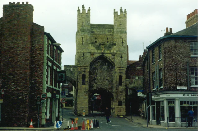
Roman Wall Approximately 20 Metres South East Of Monk Bar — Grade I listed wall in York, United Kingdom.

Wikimedia Commons contributors — see linked file page for photographer and licence licence
Plan your visit
- Typical visit
- 15 min–30 min
- Nearest railway station
- York · 1.2 km
- Free entry
- Dog-friendly
About
Roman Wall Approximately 20 Metres South East Of Monk Bar is a place of interest in Yorkshire. Officially recognised as Grade I listed building. It sits within the York Central parliamentary constituency. The nearest railway station is York, about 1.2 km away. Postcode area YO1.
Photo gallery
Place summary
The Roman Wall Approximately 20 Metres South East Of Monk Bar is a Grade I listed structure located in the unparished area of York, Yorkshire. This section of the Roman fortifications represents the historical significance of York's ancient defensive walls.
AI-generated from the structured facts on this page (operator, designation, listing, era). Not a substitute for visiting.
- Coordinates
- 53.9621, -1.0775
- District
- York
- Parish
- York, unparished area
- Postcode
- YO1 7BT
- Parliamentary constituency
- York Central
- Nearest railway station
- York — 1.2 km
- Official site
- www.thehilt.co.uk
Sources
- wikidata: Q17530664 (CC0)
- commons: Wall near Monk Bar - geograph.org.uk - 677008.jpg (CC BY-SA 4.0)
Other places nearby
Loading nearby places…
Nearby
 📷 3
📷 3Historic houses · Yorkshire & the Humber
The Oliver Sheldon House
The Oliver Sheldon House — Grade II* listed building in York, North Yorkshire, England, UK.
Hotels · Yorkshire & the Humber
DoubleTree by Hilton York
DoubleTree by Hilton York — a hotel in england yorkshire. 4-star. Brand: DoubleTree.
 📷 5
📷 5Historic bridges · Yorkshire & the Humber
City Walls
City Walls is a historic bridge in the United Kingdom.
 📷 3
📷 3Museums · Yorkshire & the Humber
Richard III Experience at Monk Bar
Richard III Experience at Monk Bar — museum in the City of York, North Yorkshire, England.
📷 5Historic bridges · Yorkshire & the Humber
City Walls
City Walls is a historic bridge in the United Kingdom.
 📷 3
📷 3Historic houses · Yorkshire & the Humber
Bedern Hall
Bedern Hall — Grade II* listed building in York, North Yorkshire, England, UK.
More places in this region
 📷 3
📷 3Holy wells · Yorkshire & the Humber
Curtain Wall
Curtain Wall — Grade I listed wall in York, United Kingdom.
 📷 3
📷 3Holy wells · Yorkshire & the Humber
Garden walls and gatepiers to the Abbey House
Garden walls and gatepiers to the Abbey House — Grade I listed wall in Whitby, North Yorkshire, England, UK.
 📷 3
📷 3Holy wells · Yorkshire & the Humber
Gatehouse And Walls Adjoining To Bishopthorpe Palace
Gatehouse And Walls Adjoining To Bishopthorpe Palace — wall in Bishopthorpe, City of York, England, UK.
 📷 3
📷 3Holy wells · Yorkshire & the Humber
St Mary's Abbey remains precinct walls including St Mary's Tower
St Mary's Abbey remains precinct walls including St Mary's Tower — Grade I listed building in York, United Kingdom.
Frequently asked questions
- Where is Roman Wall Approximately 20 Metres South East Of Monk Bar?
- Roman Wall Approximately 20 Metres South East Of Monk Bar is in Yorkshire, United Kingdom (postcode YO1 7BT), in the parish of York, unparished area.
- Is Roman Wall Approximately 20 Metres South East Of Monk Bar a listed building?
- Roman Wall Approximately 20 Metres South East Of Monk Bar is officially recognised as Grade I listed building listed.
- Is Roman Wall Approximately 20 Metres South East Of Monk Bar free to visit?
- Yes, Roman Wall Approximately 20 Metres South East Of Monk Bar is free to enter.
- How do I get to Roman Wall Approximately 20 Metres South East Of Monk Bar?
- The nearest railway station is York, about 1.2 km away. Drivers can navigate to postcode YO1 7BT.