
Historic houses · South West England
Roman Town House, Dorchester
In or near Charminster.
Roman Town House, Dorchester — Grade I listed house in West Dorset, England, UK.

Wikimedia Commons contributors — see linked file page for photographer and licence licence

Plan your visit
- Typical visit
- 1 h–2 h
- Nearest railway station
- Dorchester West · 0.7 km
- Family-friendly
- Limited wheelchair access
Getting there & planning your visit
To visit the Roman Town House in Dorchester, the nearest railway station is Dorchester West, which is 0.7 km away. The postcode for sat-nav is DT1 1XN. Please note that accessibility is limited for wheelchair users.
About
Roman Town House, Dorchester is a historic house in the United Kingdom — typically a country seat, manor, or town house with notable architecture or history. Heritage designation: scheduled monument. Wikidata describes it as: "Grade I listed house in West Dorset, England, UK". Coordinates: 50.7174°, -2.4410°.
Photo gallery
Summary from the official site
The Roman Town House is located in Colliton Park, Dorchester, and is part of the historical site of the Roman town Durnovaria. It is managed by Dorset Council and offers tours and educational visits, as well as space for events.
Read more on the official property page.
Protected designations
- Area of Outstanding Natural Beauty: Dorset
Designations sourced from Natural England open data under OGL v3.
From the Wikipedia article
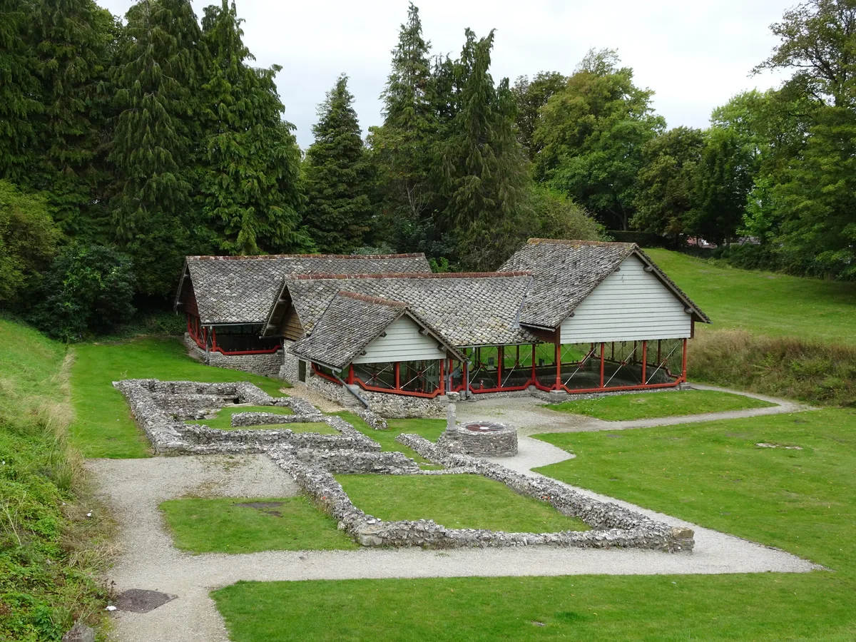
The Roman Town House in Dorchester is a Roman ruin within Colliton Park, Dorchester, Dorset, England. Dorset County Council acquired Colliton Park in 1933 as the site for the construction of County Hall. The Town House was discovered in 1937/38 during an archaeological investigation carried out by the Dorset Natural History and Archaeological Society prior to the construction of the new building. Plans for County Hall were modified so that the Town House could be retained on site. The Town House is a scheduled monument and a Grade I listed building. It is bounded on the north and west sides by North Walk and West Walk which are also scheduled monuments having the remains of the Roman ramparts of the town just below surface level. Built around 307 AD and extended in 341 AD, the Town House has two principal ranges of rooms. The South Range comprising rooms 1–7 survives in the plan form of flint and stone walls on the grass covered site. The West Range comprising rooms 8–18 was mosaic floored. This range was re-excavated and provided with a steel and glass cover building with a stone tiled roof all perched on the original foundations between 1996 and 1999.
Excerpt from Wikipedia under CC BY-SA 4.0. See the source article linked in Sources below.
Background
Visiting
The site is owned by Dorset Council and the grounds are free to visit. Dorset Museum manage events and provide access to the inside of the structure on tours.
Sourced from Wikipedia under CC BY-SA 4.0.
- Coordinates
- 50.7174, -2.4410
- District
- Dorset
- Parish
- Dorchester
- Postcode
- DT1 1XN
- Parliamentary constituency
- West Dorset
- Phone
- +44 1305 224283
- Established
- 307
- Nearest railway station
- Dorchester West — 0.7 km
Sources
- wikidata: Q7362214 (CC0)
- wikipedia: Roman Town House, Dorchester (CC BY-SA 4.0)
- commons: Roman Town House, Dorchester.jpg (CC BY-SA 4.0)
Other places nearby

Roman Town House
Archaeological sites · 0.0 km

County Hall, Dorchester
Gardens · 0.1 km

Bridge, 30 Feet North Of The Bridge 40 Feet East Of Hangmans Cottage, On Path Leading Towards Frome Whitfield House
Historic bridges · 0.1 km

Dorset County Council
Museums · 0.1 km

Bridge Over River Frome On Charminster Road 75 Yards North Of Junction With A37 (Maiden Newton Road)
Historic bridges · 0.2 km

Bridge Over River Frome On A37 (Maiden Newton Road) 50 Yards North Of Junction With Charminster Road
Historic bridges · 0.2 km

Thomas Hardy Statue
Public art & sculpture · 0.3 km

Tolpuddle Martyrs
Memorials & monuments · 0.3 km
Durnovaria
Hill forts · 0.3 km

Dorchester Castle
Castles · 0.3 km
Dorchester Castle
Literary houses · 0.3 km

The Tutankhamun Exhibition
Museums · 0.3 km
Nearby
📷 5Archaeological sites · South West England
Roman Town House
Roman Town House — a archaeological in england-south-east, United Kingdom.
📷 5Gardens · South West England
County Hall, Dorchester
County Hall, Dorchester — a garden in england-south-east, United Kingdom.
📷 5Historic bridges · South West England
Bridge, 30 Feet North Of The Bridge 40 Feet East Of Hangmans Cottage, On Path Leading Towards Frome Whitfield House
Bridge, 30 Feet North Of The Bridge 40 Feet East Of Hangmans Cottage, On Path Leading Towards Frome Whitfield House — Grade II listed building-listed bridge in england-south-east, United Kingdom.
📷 5Museums · South West England
Dorset County Council
Dorset County Council — a museum in england-south-east, United Kingdom.
📷 5Historic bridges · South West England
Bridge Over River Frome On Charminster Road 75 Yards North Of Junction With A37 (Maiden Newton Road)
Bridge Over River Frome On Charminster Road 75 Yards North Of Junction With A37 (Maiden Newton Road) — Grade II listed building-listed bridge in england-south-east, United Kingdom.
📷 5Historic bridges · South West England
Bridge Over River Frome On A37 (Maiden Newton Road) 50 Yards North Of Junction With Charminster Road
Bridge Over River Frome On A37 (Maiden Newton Road) 50 Yards North Of Junction With Charminster Road — Grade II listed building-listed bridge in england-south-east, United Kingdom.
Where to eat & stay near Roman Town House, Dorchester
Places to stay
 📷 7
📷 7Hotels · South West England
Kings Arms Hotel
Kings Arms Hotel — a hotel in england south east.
 📷 5
📷 5Caravan parks · South West England
The Manor House
The Manor House — a caravan park in england south east.
 📷 5
📷 5 📷 5
📷 5Caravan parks · South West England
Hardy Country Park
Hardy Country Park — a caravan park in england south west.
 📷 5
📷 5 📷 5
📷 5Caravan parks · South West England
Warmwell Caravan Park
Warmwell Caravan Park — a caravan park in england south east.
Places to eat & drink
 📷 5
📷 5Historic pubs · South West England
Plume Of Feathers Public House
Plume Of Feathers Public House in England South West, United Kingdom.
 📷 7
📷 7Historic pubs · South West England
Old House at Home
Old House at Home in England South West, United Kingdom.
 📷 5
📷 5Historic pubs · South West England
Junction Hotel
Junction Hotel in England South West, United Kingdom.
 📷 5
📷 5Historic pubs · South West England
The Royal Standard Public House
The Royal Standard Public House in England South West, United Kingdom.
 📷 7
📷 7Historic pubs · South West England
The Old Swan Public House
The Old Swan Public House in England South West, United Kingdom.
 📷 7
📷 7Historic pubs · South West England
The Spice Ship Inn
The Spice Ship Inn in England South West, United Kingdom.
More historic houses in this region
 📷 5
📷 5Historic houses · South West England
1 South Parade
1 South Parade — Grade I listed house in Bath, Somerset, England, UK.
_(geograph_6440799).jpg?width=1200) 📷 5
📷 5Historic houses · South West England
1-4 Lansdowne Grove, Morris Lane
1-4 Lansdowne Grove, Morris Lane — houses in Devizes, Wiltshire, England, UK.
 📷 5
📷 5Historic houses · South West England
2 North Parade
2 North Parade — building in Bath, UK; part of Abbey Hotel.
 📷 5
📷 5Historic houses · South West England
2, South Place, Lacock Road
2, South Place, Lacock Road — house in Corsham, Wiltshire, England, UK.
Frequently asked questions
- Where is Roman Town House, Dorchester?
- Roman Town House, Dorchester is in South-West England, United Kingdom (postcode DT1 1XN), in the parish of Dorchester.
- What is Roman Town House, Dorchester?
- Roman Town House, Dorchester — Grade I listed house in West Dorset, England, UK.
- How do I get to Roman Town House, Dorchester?
- The nearest railway station is Dorchester West, about 0.7 km away. The nearest town is Charminster. Drivers can use postcode DT1 1XN.
- When was Roman Town House, Dorchester built?
- Built or established in 307.
- Who owns Roman Town House, Dorchester?
- Roman Town House, Dorchester is owned by Dorset Council.
- Is Roman Town House, Dorchester a listed building?
- Roman Town House, Dorchester is officially recognised as scheduled monument listed.
- Is Roman Town House, Dorchester a protected site?
- Yes — Roman Town House, Dorchester is part of the Dorset National Landscape (AONB).
- How do I get to Roman Town House, Dorchester?
- The nearest railway station is Dorchester West, about 0.7 km away. Drivers can navigate to postcode DT1 1XN.