Natural landmarks · Central Scotland
Rob Roy Way
In or near Crianlarich.
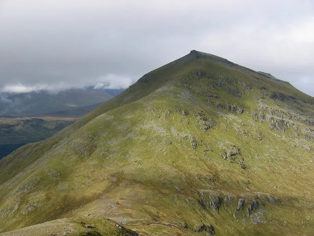
79-mile Highland route through Rob Roy MacGregor's Trossachs country.

Mick Garratt — CC BY-SA 2.0 via Wikimedia Commons licence
Plan your visit
- Typical visit
- 1 h–2 h
- Nearest railway station
- Crianlarich · 7.4 km
- Free entry
- Dog-friendly
- Limited wheelchair access
Getting there & planning your visit
To visit the Rob Roy Way in central Scotland, the nearest railway station is Crianlarich, which is 7.4 km away. Entry is free, but wheelchair access is limited.
About
The Rob Roy Way is a 79-mile long-distance route through the Trossachs and southern Highlands from Drymen to Pitlochry, named for the Highland outlaw Rob Roy MacGregor (1671-1734). Passes Loch Lomond, Loch Katrine, Killin and Glen Lochay.
Photo gallery
From the Wikipedia article
The Rob Roy Way is a Scottish long distance footpath that runs from Drymen in Stirling to Pitlochry in Perth and Kinross. The path was created in 2002, and takes its name from Rob Roy MacGregor, a Scottish folk hero and outlaw of the early 18th century. It traverses countryside that he knew and travelled frequently. The route crosses the Highland Boundary Fault, a geological fault where the Highlands meet the Lowlands. Views from the trail overlook Loch Lubnaig, Loch Earn, Loch Venachar and Loch Tay. The way is 127 kilometres (79 mi) in length if the direct route along the southern shore of Loch Tay and the River Tay is followed between Ardtalnaig and Aberfeldy. An optional loop also links these places via Amulree: choosing this option increases the length by a further 27 kilometres (17 mi) to 154 kilometres (96 mi). The Rob Roy Way was designated as one of Scotland's Great Trails by NatureScot in spring 2012, and also links to two further Great Trails, meeting the Great Trossachs Path near Callander, and the West Highland Way just north of Drymen. The Rob Roy Way also shares sections of route with Route 7 of the National Cycle Network, which also links Drymen and Pitlochry. Shared sections include the minor road on the south side of Loch Tay and the section following the route of the former Callander and Oban Railway, including Glen Ogle viaduct. Besides Drymen and Pitlochry, the way passes through Aberfoyle, Callander, Strathyre, Killin, Amulree and Aberfeldy. About 3,000 people use the path every year, of whom about 450 complete the entire route.
Excerpt from Wikipedia under CC BY-SA 4.0. See the source article linked in Sources below.
- Coordinates
- 56.4000, -4.5000
- Address
- Stirling and Perth and Kinross, Scotland
- Established
- 2002
- Nearest railway station
- Crianlarich — 7.4 km
- Official site
- www.robroyway.com
Sources
- manual: rob-roy-way (manual)
- wikipedia: Rob Roy Way (CC BY-SA 4.0)
Other places nearby

Stob an t-Suidhe
Mountains & hills · 1.4 km

Lochan Dùn Saoraich
Reservoirs & lochs · 1.5 km

Dun Riobain
Mountains & hills · 2.2 km
Dun Riobain
Mountains & hills · 2.3 km

Bridge over River Dochart, Loch Dochart House
Historic bridges · 2.3 km

Stob Luib
Mountains & hills · 2.5 km

Stob Creagach
Mountains & hills · 2.7 km

Stob Creagach
Mountains & hills · 2.8 km

Luib railway station
Natural landmarks · 2.9 km

Glen Dochart Caravan Park
Caravan parks · 2.9 km

Ben More
Mountains & hills · 2.9 km
Ben More
Natural landmarks · 2.9 km
Nearby
📷 5Mountains & hills · Central Scotland
Stob an t-Suidhe
Stob an t-Suidhe — a hill or mountain in scotland central.
📷 4Reservoirs & lochs · Central Scotland
Lochan Dùn Saoraich
Lochan Dùn Saoraich in Scotland Islands, United Kingdom.
📷 5Mountains & hills · Central Scotland
Dun Riobain
Dun Riobain — a hill or mountain in scotland highlands.
📷 5Mountains & hills · Central Scotland
Dun Riobain
Dun Riobain — mountain in scotland highlands. Elevation: 225 m.
📷 5Historic bridges · Central Scotland
Bridge over River Dochart, Loch Dochart House
Bridge over River Dochart, Loch Dochart House — category B listed building-listed bridge in scotland-highlands, United Kingdom.
📷 5Mountains & hills · Central Scotland
Stob Luib
Stob Luib — mountain in scotland central. Elevation: 492 m.
Where to eat & stay near Rob Roy Way
Places to stay
📷 5Caravan parks · Central Scotland
Glen Dochart Caravan Park
Glen Dochart Caravan Park — a caravan park in scotland central.
 📷 5
📷 5Hostels · Central Scotland
Inverardran Cottage
Inverardran Cottage — a hostel in scotland highlands.
 📷 5
📷 5Hostels · Central Scotland
Loch Voil Hostel
Loch Voil Hostel — a hostel in scotland central.
 📷 5
📷 5Hostels · Central Scotland
Crianlarich Youth Hostel
Crianlarich Youth Hostel — a hostel in scotland highlands.
 📷 5
📷 5Campsites · Central Scotland
Strathfillan Wigwams
Strathfillan Wigwams — a campsite in scotland highlands.
 📷 5
📷 5Caravan parks · Central Scotland
Balquhidder Braes Holiday Park
Balquhidder Braes Holiday Park — a caravan park in scotland central.
Places to eat & drink
 📷 5
📷 5Historic pubs · Central Scotland
The Drovers Inn
The Drovers Inn — Historic pub — listed building or notable heritage status.
Other natural landmarks from this era
_(cropped).JPG?width=1200) 📷 5
📷 5Natural landmarks · London
George Stuart White
George Stuart White — Public artwork (statue).
 📷 5
📷 5 📷 5
📷 5Natural landmarks · London
John Keats
John Keats — Public artwork (statue) by Stuart Williamson.
 📷 5
📷 5More natural landmarks in this region
 📷 4
📷 4Natural landmarks · Central Scotland
Blackadder Water
Blackadder Water in England North East, United Kingdom.
 📷 3
📷 3Natural landmarks · Central Scotland
A6105 road
A6105 road in England North East, United Kingdom.
 📷 3
📷 3 📷 3
📷 3Frequently asked questions
- Where is Rob Roy Way?
- Rob Roy Way is in central Scotland, United Kingdom.
- What is Rob Roy Way?
- 79-mile Highland route through Rob Roy MacGregor's Trossachs country.
- How do I get to Rob Roy Way?
- The nearest railway station is Crianlarich, about 7.4 km away. Its coordinates are 56.4000°, -4.5000°.
- When was Rob Roy Way built?
- Built or established in 2002.
- Is Rob Roy Way free to visit?
- Yes, Rob Roy Way is free to enter.
- How do I get to Rob Roy Way?
- The nearest railway station is Crianlarich, about 7.4 km away.