
Mountains & hills · North West England
Rivington Pike
In or near Haigh.
Rivington Pike — Named summit at 363 m.

Wikimedia Commons contributors — see linked file page for photographer and licence licence

Plan your visit
- Typical visit
- 3 h–8 h
- Best time of year
- Late spring – early autumn (May–Oct)
- Nearest railway station
- Blackrod · 3.7 km
- Free entry
- Dog-friendly
About
Rivington Pike is a named summit in the United Kingdom. Wikidata describes it as: "Named summit at 363 m.". Coordinates: 53.6194°, -2.5412°.
Photo gallery
Protected designations
- Site of Special Scientific Interest: West Pennine Moors SSSI
Designations sourced from Natural England open data under OGL v3.
From the Wikipedia article
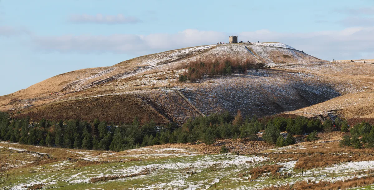
Rivington Pike is a hill on Winter Hill, part of the West Pennine Moors at Rivington, Chorley in Lancashire, England. The nearest towns are Adlington and Horwich. The land and building are owned and managed by Chorley Council. The Pike Tower is a prominent local landmark located below the summit, it is part of Lever Park. The area is popular with hill walkers and for mountain biking.
Excerpt from Wikipedia under CC BY-SA 4.0. See the source article linked in Sources below.
Background
History
The Pike has many prehistoric sites nearby, at Noon Hill tumulus on Winter Hill, Pike Stones and Two Lads, in the valley is Coblowe hillock by the Lower Rivington Reservoir. There are records of flint chipping being found at the Pike and moorland. A flint spear head was found at the nearby 'Tigers Clough'. There is a feature at the summit of the hill which the author Fergusson Irvine in his 1904 book described as a 'a curious hog-backed mound'. Of the hill he states "no doubt it is mainly a natural feature, but there are distinct traces of its having been trimmed and the approach steepened at several points". and he also states it is possible that a standing stone occupied the summit in the…
Visiting
Belmont Road (USRN 7400767) and Roynton Road (USRN 7400820) are the two roads that provide access to the hillside, the Terraced Gardens, the Pike and Winter Hill from the direction of Chorley, Belmont and Horwich. Both are open public roads recorded on the National Street Gazetteer which are public and under the control of the Lancashire County Council with adopted status and statutory protection by way of the Highways Act 1980. Gates placed on these roads must not be locked shut. The speed advice is a maximum of 5 mph. Belmont Road forks at the Pigeon Tower. The descending road has washed away. The continuation of the road to the right heads to Rivington Road and is now a dirt track across…
Sourced from Wikipedia under CC BY-SA 4.0.
- Coordinates
- 53.6194, -2.5412
- District
- Bolton
- Parish
- Horwich
- Postcode
- BL6 6RU
- Parliamentary constituency
- Bolton West
- Nearest railway station
- Blackrod — 3.7 km
Sources
- osm: n339320422 (ODbL)
- wikipedia: Rivington Pike (CC BY-SA 4.0)
- commons: Rivington Pike Winter 1.jpg (CC BY-SA 4.0)
Other places nearby
Rivington Pike
Natural landmarks · 0.0 km

Brown Hill
Mountains & hills · 0.3 km

Terraced Gardens
Gardens · 0.4 km

The Ravine
Viewpoints · 0.4 km

Terraced Gardens, Rivington
Gardens · 0.5 km

Great Lawn
Viewpoints · 0.5 km

Rivington Gardens
Gardens · 0.5 km

Belmont Lodge
Viewpoints · 0.5 km

Two Archways And Associated Stone Staircases And Retaining Walls In Rivington Gardens At Sd 6390 1422
Memorials & monuments · 0.6 km

Lever Bridge, Staircases And A Summer House In Rivington Gardens At Sd 6384 1422
Historic bridges · 0.6 km

Pigeon Tower
Archaeological sites · 0.6 km

Crooked Edge Hill
Mountains & hills · 1.0 km
Nearby
📷 5Natural landmarks · North West England
Rivington Pike
Rivington Pike — hill in Lancashire, England.
📷 5Mountains & hills · North West England
Brown Hill
Brown Hill — mountain in england north west. Elevation: 325 m.
📷 3Gardens · North West England
Terraced Gardens
Terraced Gardens — a garden in england-north-west, United Kingdom.
📷 3Viewpoints · North West England
The Ravine
The Ravine is a viewpoint in the United Kingdom.
📷 4Gardens · North West England
Terraced Gardens, Rivington
Terraced Gardens, Rivington — Landscaped woodland in Lancashire, England.
📷 4Viewpoints · North West England
Great Lawn
Great Lawn is a viewpoint in the United Kingdom.
Where to eat & stay near Rivington Pike
Places to stay
 📷 5
📷 5Caravan parks · North West England
Wilcocks Farm Caravan Park
Wilcocks Farm Caravan Park — a caravan park in england north west.
 📷 5
📷 5Caravan parks · North West England
Home Farm Caravan Site
Home Farm Caravan Site — a caravan park in england north west.
 📷 5
📷 5Hotels · North West England
Bolton Georgian House Hotel
Bolton Georgian House Hotel — a hotel in england north west.
 📷 5
📷 5Campsites · North West England
Bibbys Farm Scout Camp
Bibbys Farm Scout Camp — a campsite in england north west.
 📷 5
📷 5Campsites · North West England
Primrose Cottage Camping
Primrose Cottage Camping — a campsite in england north west.
 📷 7
📷 7Places to eat & drink
 📷 7
📷 7Historic pubs · North West England
Blundell Arms
Blundell Arms in England North West, United Kingdom.
 📷 5
📷 5Historic pubs · North West England
Bradley Hall Public House
Bradley Hall Public House in England North West, United Kingdom.
 📷 5
📷 5Historic pubs · North West England
Ye Olde Man & Scythe
Ye Olde Man & Scythe — Historic pub — listed building or notable heritage status.
 📷 6
📷 6Historic pubs · North West England
Royal Oak Hotel
Royal Oak Hotel in England North West, United Kingdom.
 📷 7
📷 7Historic pubs · North West England
The Whitesmiths Arms
The Whitesmiths Arms in England North West, United Kingdom.
 📷 5
📷 5More mountains in this region
 📷 5
📷 5Mountains & hills · North West England
Appleton Park
Appleton Park — a hill or mountain in england west midlands.
 📷 5
📷 5Mountains & hills · North West England
High Warren
High Warren — mountain in england west midlands. Elevation: 105 m.
 📷 5
📷 5Mountains & hills · North West England
Alderley Edge
Alderley Edge — mountain in england west midlands. Elevation: 194 m.
 📷 3
📷 3Frequently asked questions
- Where is Rivington Pike?
- Rivington Pike is in North-West England, United Kingdom (postcode BL6 6RU), in the parish of Horwich.
- What is Rivington Pike?
- Rivington Pike — Named summit at 363 m.
- How do I get to Rivington Pike?
- The nearest railway station is Blackrod, about 3.7 km away. The nearest town is Haigh. Drivers can use postcode BL6 6RU.
- Is Rivington Pike a protected site?
- Yes — Rivington Pike is part of the West Pennine Moors SSSI Site of Special Scientific Interest.
- Is Rivington Pike free to visit?
- Yes, Rivington Pike is free to enter.
- How do I get to Rivington Pike?
- The nearest railway station is Blackrod, about 3.7 km away. Drivers can navigate to postcode BL6 6RU.