
Historic churches · East Midlands
River Welland
In or near Sutterton.
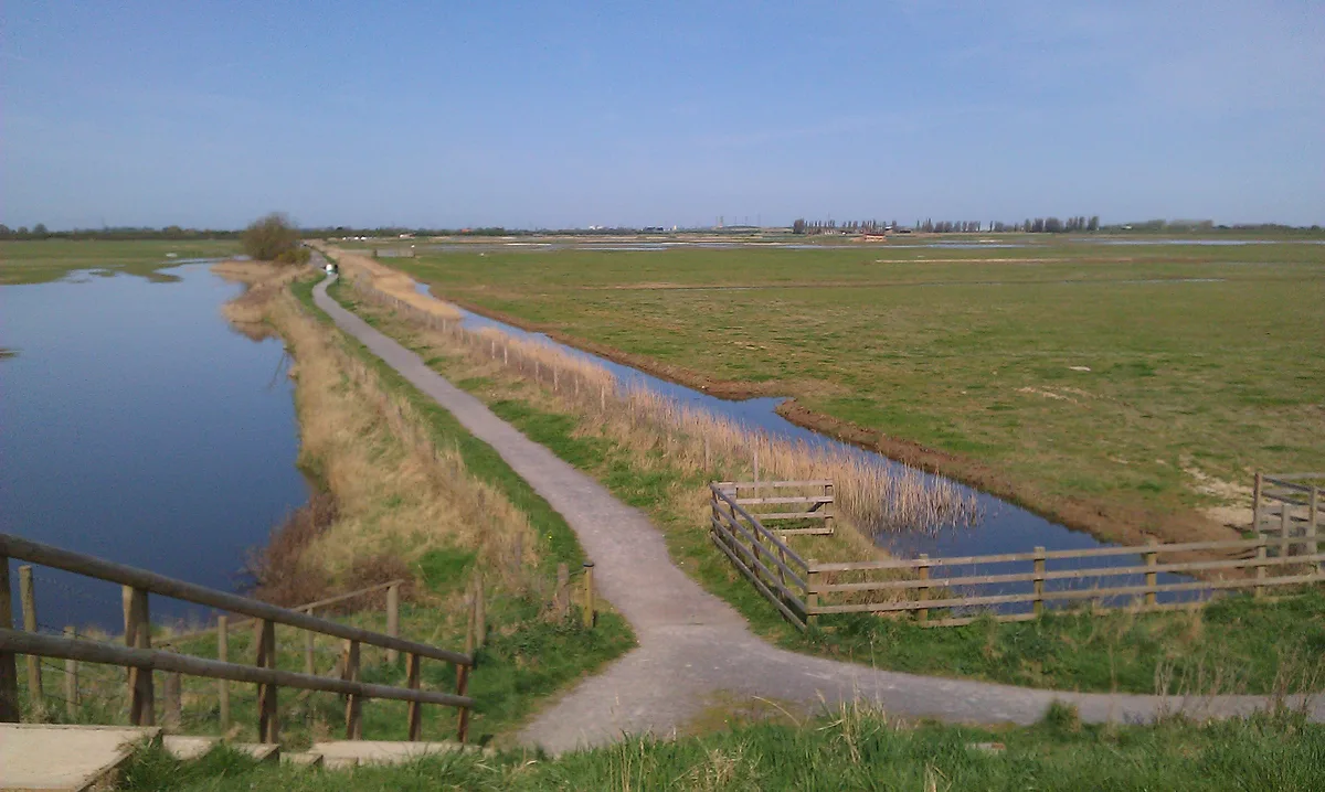
River Welland — a church in england-east-midlands, United Kingdom.

Mat Fascione — CC BY-SA 2.0 via Wikimedia Commons licence

Plan your visit
- Typical visit
- 30 min–1 h
- Nearest railway station
- Boston · 9.8 km
- Free entry
About
River Welland is a church in england-east-midlands, United Kingdom, listed in the Wikipedia register of British heritage and tourism sites. See the linked Wikipedia article for full details.
Photo gallery
Official information
The National River Flow Archive (NRFA) is a key resource for hydrological research and water management in the UK, providing extensive data from gauging stations. It supports flood and drought management through the collection and analysis of river flow data.
Protected designations
- Site of Special Scientific Interest: The Wash SSSI
- National Nature Reserve: THE WASH
- Ramsar wetland: The Wash
Designations sourced from Natural England open data under OGL v3.
Place summary
The River Welland is located in the East Midlands. It is notable for its historical significance as a boundary for various ecclesiastical jurisdictions. The river has played an important role in the region's agricultural and transport history.
AI-generated from the structured facts on this page (operator, designation, listing, era). Not a substitute for visiting.
Background
History
The origin of the name for the river is unknown but appears to be Pre-English. In Old English the form was Weolud and may have changed to the Middle English form due to folk-etymology or Scandinavian influence. The Welland (Weolud) is first mentioned in the Anglo-Saxon Chronicle for 921 AD. During the reign of Henry III (1207–1272), complaints were made that of the two channels below Crowland, the one to Spalding was more favourable to the passage of barges, but the Abbot of Crowland had obstructed and narrowed its course by planting willow trees. In the fourteenth century, Spalding was charged with failing to scour and repair the river, causing damage to the king's liege people, but argued…
Description
Plans to re-route the outfall along a new channel which would meet the River Witham at The Scalp, near Boston, were authorised in 1794, but the money could not be raised at the time, due to the financial crisis caused by the French Wars. The effects of the embankments had resulted in the bed of the river below Fosdyke being around 7 ft lower by 1845. In 1867, the River Welland Outfall Act enabled the trustees to raise money to repair the walls where the tide had washed away some of the fill behind the fascines. A dredger was employed between 1889 and 1890, which had been invented by a Mr Harrison, the superintendent of works. Fulney lock was constructed at the same time to exclude the tide…
Sourced from Wikipedia under CC BY-SA 4.0.
- Coordinates
- 52.8983, 0.0308
- Nearest railway station
- Boston — 9.8 km
- Official site
- www.ceh.ac.uk
Sources
- wikipedia: River Welland (CC BY-SA 4.0)
Other places nearby

Ronald Sydney White
Memorials & monuments · 1.9 km
RSPB Frampton Marsh
Wildlife reserves · 3.1 km

Frampton Marsh Nature Reserve
Forests & woodlands · 3.4 km

Reflector
Public art & sculpture · 3.6 km

Holbeach St Marks War Memorial
Memorials & monuments · 4.1 km

Pilgrim Fathers
Memorials & monuments · 4.9 km

Fosdyke Village Sign
Public art & sculpture · 5.5 km

Fosdyke
Villages · 5.5 km

Frampton Castle
Literary houses · 5.5 km

Frampton
Villages · 5.7 km

Frampton Hall
Manor houses · 5.8 km

Humby
Villages · 6.5 km
Nearby
📷 3Memorials & monuments · East Midlands
Ronald Sydney White
Ronald Sydney White — a memorial in england-east-midlands, United Kingdom.
📷 3Wildlife reserves · East Midlands
RSPB Frampton Marsh
RSPB Frampton Marsh — RSPB nature reserve in Lincolnshire, England.
📷 3Forests & woodlands · East Midlands
Frampton Marsh Nature Reserve
Frampton Marsh Nature Reserve is a forest or woodland in the United Kingdom.
📷 3Public art & sculpture · East Midlands
Reflector
Reflector — a public art in england-east-midlands, United Kingdom.
📷 3Memorials & monuments · East Midlands
Holbeach St Marks War Memorial
Holbeach St Marks War Memorial — Grade II listed building-listed memorial in england-east-midlands, United Kingdom.
📷 3Memorials & monuments · East Midlands
Pilgrim Fathers
Pilgrim Fathers — a memorial in england-east-midlands, United Kingdom.
Where to eat & stay near River Welland
Places to stay
 📷 5
📷 5 📷 5
📷 5 📷 5
📷 5Caravan parks · East Midlands
Dougie's Caravan and Camping
Dougie's Caravan and Camping — a caravan park in england east midlands.
 📷 5
📷 5Campsites · East Midlands
Meadowvale Park
Meadowvale Park — a campsite in england east midlands.
 📷 5
📷 5Hotels · East Midlands
The White Hart Hotel
The White Hart Hotel — a hotel in england east midlands.
 📷 5
📷 5Campsites · East Midlands
WigWam Crowtree
WigWam Crowtree — a campsite in england east midlands.
Places to eat & drink
 📷 5
📷 5Historic pubs · East Midlands
The Old King's Head
The Old King's Head in England East, United Kingdom.
 📷 5
📷 5 📷 5
📷 5Restaurants · East Midlands
Captain Cod Fish and Chip Restaurant
Captain Cod Fish and Chip Restaurant — a restaurant in england east midlands.
 📷 5
📷 5 📷 5
📷 5Historic pubs · East Midlands
Number 18, Formerly The Cock And Magpie Public House
Number 18, Formerly The Cock And Magpie Public House in England East, United Kingdom.
 📷 5
📷 5More places in this region
 📷 5
📷 5Historic churches · East Midlands
All Saints' Church, Stamford
All Saints' Church, Stamford — church in Stamford, Lincolnshire, England, UK.
 📷 5
📷 5Historic churches · East Midlands
Church of All Saints
Church of All Saints — church in Little Casterton, Rutland, United Kingdom.
 📷 5
📷 5Historic churches · East Midlands
Church of All Saints
Church of All Saints — church in Fenland, UK.
 📷 5
📷 5Historic churches · East Midlands
Church of St Leonard
Church of St Leonard — church in Fenland, UK.
Frequently asked questions
- Where is River Welland?
- River Welland is in the East Midlands, United Kingdom.
- What is River Welland?
- River Welland — a church in england-east-midlands, United Kingdom.
- How do I get to River Welland?
- The nearest railway station is Boston, about 9.8 km away. Its coordinates are 52.8983°, 0.0308°.
- Is River Welland a protected site?
- Yes — River Welland is part of the The Wash SSSI Site of Special Scientific Interest and the THE WASH National Nature Reserve.
- Is River Welland free to visit?
- Yes, River Welland is free to enter.