
Beaches · Scottish Islands
River Dionard
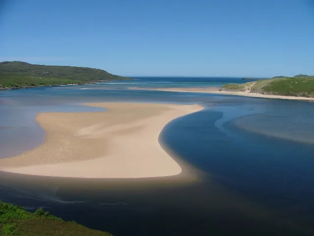
River Dionard in Scotland Islands, United Kingdom.

RH Dengate — CC BY-SA 2.0 via Wikimedia Commons licence

Plan your visit
- Typical visit
- 1 h–3 h
- Best time of year
- Summer (Jun–Aug)
- Free entry
- Family-friendly
- Dog-friendly
About
River Dionard is a place of interest in Scotland Islands, United Kingdom — drawn from open-data sources for visitor reference. See the linked Wikipedia article for the full description.
Photo gallery
From the Wikipedia article
The River Dionard is a river in the historic county of Sutherland in northwest Scotland. It arises as the outflow from Loch Dionard which lies below the eastern side of Foinaven and flows north-northwest through Strath Dionard below that mountain's eastern flanks for 7 km before turning north and then northeast towards the head of the Kyle of Durness. Its winding channel is exposed at low tide within the sands of this shallow firth which connects with the Atlantic Ocean on the north coast. The principal headwater stream feeding Loch Dionard is the Allt an Easain Ghill which passes through two lochans beneath Meall Horn; the upper Lochan Ulbha and the lower An Dubh-loch. The nearby Allt Eilidh a' Chleirich flows from a third lochan, Lochan Sgeireach. There are numerous other streams and lochans in the upper catchment. The Gualin National Nature Reserve has been established within the catchment. The name may be from dyn-fjordr, 'noisy-firth.'
Excerpt from Wikipedia under CC BY-SA 4.0. See the source article linked in Sources below.
- Coordinates
- 58.5202, -4.8095
- District
- Highland
- Postcode
- IV27 4QG
- Parliamentary constituency
- Caithness, Sutherland and Easter Ross
Sources
- wikidata: Q24649317 (CC0)
- wikipedia: River Dionard (CC BY-SA 4.0)
Other places nearby

Bridge, Drochaid Mhor
Historic bridges · 2.1 km

Web Cave
Caves · 2.8 km

Meall an Fheadain
Mountains & hills · 3.0 km

Beinn an Amair
Mountains & hills · 3.0 km
Beinn an Amair
Mountains & hills · 3.1 km

Beinn Akie
Mountains & hills · 3.3 km
Beinn Akie
Mountains & hills · 3.4 km
Kyle of Durness
Mountains & hills · 3.5 km

Ghlas-bheinn
Mountains & hills · 3.6 km

Meall nan Cra
Mountains & hills · 3.8 km

Keoldale
Villages · 4.0 km

Meall Meadhonach
Mountains & hills · 4.5 km
Nearby
📷 5Historic bridges · Scottish Islands
Bridge, Drochaid Mhor
Bridge, Drochaid Mhor — category B listed building-listed bridge in scotland-islands, United Kingdom.
📷 5📷 5Mountains & hills · Scottish Islands
Meall an Fheadain
Meall an Fheadain — a hill or mountain in scotland islands.
📷 5Mountains & hills · Scottish Islands
Beinn an Amair
Beinn an Amair — a hill or mountain in scotland islands.
📷 5Mountains & hills · Scottish Islands
Beinn an Amair
Beinn an Amair — mountain in scotland islands. Elevation: 277 m.
📷 5Mountains & hills · Scottish Islands
Beinn Akie
Beinn Akie — mountain in scotland islands. Elevation: 288 m.
Where to eat & stay near River Dionard
Places to stay
 📷 5
📷 5Caravan parks · Scottish Highlands
Choraidh Croft
Choraidh Croft — a caravan park in scotland highlands.
 📷 5
📷 5Caravan parks · Scottish Islands
Balnakeil Motorhome Stopover
Balnakeil Motorhome Stopover — a caravan park in scotland islands.
 📷 5
📷 5Hostels · Scottish Islands
Lazy Crofter Bunkhouse/Hostel
Lazy Crofter Bunkhouse/Hostel — a hostel in scotland islands.
📷 5 📷 5
📷 5Campsites · Scottish Islands
Sango Sands
Sango Sands — a campsite in scotland islands.
 📷 5
📷 5Hostels · Scottish Islands
Durness Youth Hostel
Durness Youth Hostel — a hostel in scotland islands.
More beaches in this region
 📷 3
📷 3 📷 3
📷 3 📷 3
📷 3Beaches · Scottish Islands
An Tràigh-lochain
An Tràigh-lochain is a beach in the United Kingdom.
 📷 3
📷 3Frequently asked questions
- Where is River Dionard?
- River Dionard is in the Scottish Islands, United Kingdom (postcode IV27 4QG).
- What is River Dionard?
- River Dionard in Scotland Islands, United Kingdom.
- How do I get to River Dionard?
- Drivers can use postcode IV27 4QG.
- Is River Dionard free to visit?
- Yes, River Dionard is free to enter.
- How do I get to River Dionard?
- Drivers can navigate to postcode IV27 4QG. It sits within the Caithness, Sutherland and Easter Ross parliamentary constituency.