
Hill forts · South West England
Ringmoor stone row and cairn circle
In or near Yelverton.
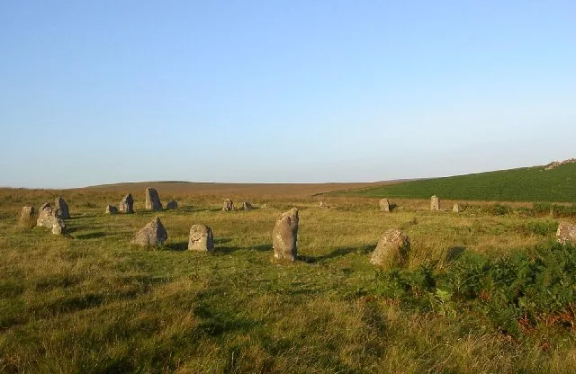
Ringmoor stone row and cairn circle — archaeological site in Sheepstor, Devon, UK.

Wikimedia Commons contributors — see linked file page for photographer and licence licence

Plan your visit
- Typical visit
- 1 h–2 h
- Nearest railway station
- Plym Bridge · 8.3 km
- Free entry
- Dog-friendly
About
Ringmoor stone row and cairn circle is a hill fort in the United Kingdom. Wikidata describes it as: "archaeological site in Sheepstor, Devon, UK". Coordinates: 50.4748°, -4.0258°.
Photo gallery
From the Wikipedia article
Ringmoor stone row and cairn circle (grid reference SX563658) is a prehistoric stone row and cairn circle on Ringmoor Down in Devon. It is located three miles east of the A386, northeast of the village of Shaugh Prior. It is three hundred metres north from Brisworthy stone circle, and is one of the archaeological sites found in the Upper Plym Valley.
Excerpt from Wikipedia under CC BY-SA 4.0. See the source article linked in Sources below.
Background
Description
The stone row is 356 metres long. It is mainly single, but is double in parts. At the southern end is a cairn circle with a diameter of 12.6 metres. The central cairn is 9.5 metres in diameter and has a height of 0.4 metres. A standing stone terminates the stone row at the northern end. Many of the stones in the stone row are missing, and have clearly been robbed for use elsewhere. The cairn circle had also been robbed, and at the beginning of the 20th century there was only one stone standing, with four fallen and the presumed sites of six other stones represented by pits. In 1909 the circle was restored and five of the present stones were introduced from elsewhere.
Sourced from Wikipedia under CC BY-SA 4.0.
- Coordinates
- 50.4748, -4.0258
- County
- Devon
- District
- West Devon
- Parish
- Meavy
- Postcode
- PL7 5EL
- Parliamentary constituency
- South West Devon
- Nearest railway station
- Plym Bridge — 8.3 km
Sources
- wikidata: Q14949377 (CC0)
- wikipedia: Ringmoor stone row and cairn circle (CC BY-SA 4.0)
- commons: Ringmoor Down Circle.jpg (CC BY-SA 4.0)
Other places nearby

Ringmoor Down Stone Circle
Stone circles · 0.1 km
Brisworthy stone circle
Hill forts · 0.4 km

Vermine Trap
Archaeological sites · 0.8 km

Legis Tor
Mountains & hills · 0.8 km
.jpg?width=1200)
Prehistoric settlement, three round cairns and a post-medieval rabbit warren at Legis Tor
Archaeological sites · 1.0 km
Legis Tor Warren
Natural landmarks · 1.1 km

Gutter Tor
Mountains & hills · 1.5 km

Gutter Tor Trig Point
Memorials & monuments · 1.5 km

Cadover Cross
Historic houses · 1.5 km

Trowlesworthy Warren Pillow Mounds
Archaeological sites · 1.5 km

Sheepstor
Villages · 1.8 km

Sheepstor War Memorial
Memorials & monuments · 1.8 km
Nearby
📷 3Stone circles · South West England
Ringmoor Down Stone Circle
Ringmoor Down Stone Circle — a stone circle in South West England, United Kingdom.
📷 5Hill forts · South West England
Brisworthy stone circle
Brisworthy stone circle — stone circle on Dartmoor, Devon, England, UK.
📷 3Archaeological sites · South West England
Vermine Trap
Vermine Trap — an archaeological site in South West England, United Kingdom.
📷 5Mountains & hills · South West England
Legis Tor
Legis Tor — mountain in england south west. Elevation: 310 m.
📷 5Archaeological sites · South West England
Prehistoric settlement, three round cairns and a post-medieval rabbit warren at Legis Tor
Prehistoric settlement, three round cairns and a post-medieval rabbit warren at Legis Tor — archaeological site in Sheepstor, West Devon, England, UK.
📷 3Natural landmarks · South West England
Legis Tor Warren
Legis Tor Warren — a natural landmark in South West England, United Kingdom.
Where to eat & stay near Ringmoor stone row and cairn circle
Places to stay
 📷 4
📷 4Caravan parks · South West England
Dartmoor Caravan Park
Dartmoor Caravan Park — a caravan park in england south west.
 📷 5
📷 5B&Bs · South West England
The Cider House
The Cider House — a bed-and-breakfast in england south west.
 📷 5
📷 5Campsites · South West England
Plume of Feathers Campsite
Plume of Feathers Campsite — a campsite in england south west.
 📷 5
📷 5B&Bs · South West England
Tor Royal B&B
Tor Royal B&B — a bed-and-breakfast in england south west.
 📷 5
📷 5Campsites · South West England
Langstone Manor Park
Langstone Manor Park — a campsite in england south west.
 📷 5
📷 5Caravan parks · South West England
Riverside Caravan Park
Riverside Caravan Park — a caravan park in england south west.
Places to eat & drink
 📷 5
📷 5Restaurants · South West England
Toby Carvery
Toby Carvery — a restaurant in england south west. Cuisine: british. Brand: Toby Carvery.
 📷 7
📷 7Historic pubs · South West England
St Elizabeth's House
St Elizabeth's House in England South West, United Kingdom.
 📷 6
📷 6Historic pubs · South West England
(White Hart Inn) Public House
(White Hart Inn) Public House in England South West, United Kingdom.
 📷 7
📷 7Restaurants · South West England
The Cornish Arms
The Cornish Arms — a restaurant in england south west.
 📷 7
📷 7Historic pubs · South West England
Sir Francis Drake Public House
Sir Francis Drake Public House in England South West, United Kingdom.
 📷 7
📷 7More places in this region
 Flagship📷 10
Hill forts · South West England
Maiden Castle
Maiden Castle — Iron Age hill fort in Dorset, England, UK.
 📷 5
📷 5Hill forts · South West England
All Cannings Cross
All Cannings Cross — archaeological site in All Cannings, Wiltshire, England, UK.
 📷 5
📷 5Hill forts · South West England
Aquae Sulis
Aquae Sulis — town in Roman Britain on the site of Bath, England.
 📷 5
📷 5Hill forts · South West England
Aston Valley Barrow Cemetery
Aston Valley Barrow Cemetery — group of Bronze Age burial mounds in England.
Frequently asked questions
- Where is Ringmoor stone row and cairn circle?
- Ringmoor stone row and cairn circle is in Devon, South-West England, United Kingdom (postcode PL7 5EL), in the parish of Meavy.
- What is Ringmoor stone row and cairn circle?
- Ringmoor stone row and cairn circle — archaeological site in Sheepstor, Devon, UK.
- How do I get to Ringmoor stone row and cairn circle?
- The nearest railway station is Plym Bridge, about 8.3 km away. The nearest town is Yelverton. Drivers can use postcode PL7 5EL.
- Is Ringmoor stone row and cairn circle free to visit?
- Yes, Ringmoor stone row and cairn circle is free to enter.
- How do I get to Ringmoor stone row and cairn circle?
- Drivers can navigate to postcode PL7 5EL. It sits within the South West Devon parliamentary constituency.