Public art & sculpture · Central Scotland
Relief Map of the West End of Glasgow
In or near Glasgow.
Relief Map of the West End of Glasgow — a public art in scotland-central, United Kingdom.

Richard Sutcliffe — CC BY-SA 2.0 via Wikimedia Commons licence
Plan your visit
- Typical visit
- 1 h–2 h
- Nearest railway station
- Kelvinhall · 0.5 km
- Free entry
- Dog-friendly
- Wheelchair accessible
About
Relief Map of the West End of Glasgow is a public art located in scotland-central, United Kingdom. Sourced from OpenStreetMap (ODbL licence); see local listings for visitor information, opening hours and admission details.
Photo gallery
See it from the streetimagery from 2021
Imagery © Mapillary contributors, CC BY-SA 4.0
Official information
Kelvingrove Art Gallery and Museum, opened in 1901, features stunning architecture and a family-friendly atmosphere. Visitors can explore 22 galleries showcasing a diverse range of exhibits, including art, animals, and historical artifacts.
Place summary
The Relief Map of the West End of Glasgow is a public art installation located in central Scotland. This large-scale topographical model provides a three-dimensional representation of the area, showcasing its geographical features and urban layout.
AI-generated from the structured facts on this page (operator, designation, listing, era). Not a substitute for visiting.
- Coordinates
- 55.8692, -4.2921
- District
- Glasgow City
- Postcode
- G3 8AG
- Parliamentary constituency
- Glasgow North
- Phone
- +44 141 276 9599
- Nearest railway station
- Kelvinhall — 0.5 km
- Opening
- Monday to Wednesday 10am–5pm; Thursday 10am–5pm; Friday 11am–5pm; Saturday 10am–5pm; Sunday 11am–5pm
- Official site
- www.glasgowlife.org.uk
Sources
- osm: node/7158652905 (ODbL)
Other places nearby

The Cameronians (Scottish Rifles) Memorial
Memorials & monuments · 0.0 km
Cameronians War Memorial
Public art & sculpture · 0.0 km

602 (City of Glasgow) Squadron Memorial
Memorials & monuments · 0.0 km
Normandy Veterans Memorial
Memorials & monuments · 0.0 km
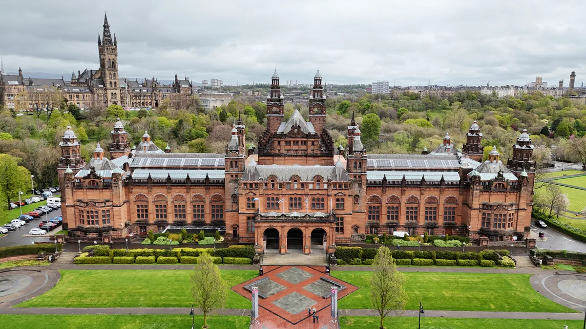
Kelvingrove Art Gallery and Museum
Galleries · 0.1 km

Bridge, Kelvingrove Park, Glasgow
Historic bridges · 0.1 km

Partick Bridge Over River Kelvin
Historic bridges · 0.1 km

Kelvin Hall
Museums · 0.1 km
Kelvin Hall International Sports Arena
Historic houses · 0.1 km
University of Glasgow Hunterian at Kelvin Hall
Museums · 0.1 km

The Sunlight Cottages
Natural landmarks · 0.2 km
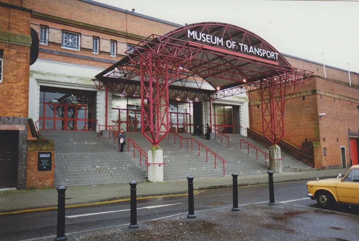
Glasgow Museum of Transport
Museums · 0.2 km
Nearby
📷 3Memorials & monuments · Central Scotland
The Cameronians (Scottish Rifles) Memorial
The Cameronians (Scottish Rifles) Memorial — a memorial in scotland-central, United Kingdom.
📷 4Public art & sculpture · Central Scotland
Cameronians War Memorial
Cameronians War Memorial in Scotland Central, United Kingdom.
📷 3Memorials & monuments · Central Scotland
602 (City of Glasgow) Squadron Memorial
602 (City of Glasgow) Squadron Memorial — a memorial in scotland-central, United Kingdom.
📷 3Memorials & monuments · Central Scotland
Normandy Veterans Memorial
Normandy Veterans Memorial — a memorial in scotland-central, United Kingdom.
📷 4Galleries · Central Scotland
Kelvingrove Art Gallery and Museum
Kelvingrove Art Gallery and Museum — Museum and art gallery near Glasgow in Scotland.
📷 5Historic bridges · Central Scotland
Bridge, Kelvingrove Park, Glasgow
Bridge, Kelvingrove Park, Glasgow — category B listed building-listed bridge in scotland-central, United Kingdom.
Where to eat & stay near Relief Map of the West End of Glasgow
Places to stay
 📷 5
📷 5 📷 5
📷 5Hostels · Central Scotland
Glasgow Youth Hostel
Glasgow Youth Hostel — a hostel in scotland central.
 📷 7
📷 7Hotels · Central Scotland
The Heritage Hotel
The Heritage Hotel — a hotel in scotland central.
 📷 5
📷 5 📷 5
📷 5 📷 5
📷 5Places to eat & drink
 📷 5
📷 5Historic pubs · Central Scotland
Hubbard Tea Rooms, 508, 510, 512 Great Western Road, Glasgow
Hubbard Tea Rooms, 508, 510, 512 Great Western Road, Glasgow in Scotland Central, United Kingdom.
 📷 5
📷 5Historic pubs · Central Scotland
Public House, 401, 403, 405, 407, 409 Sauchiehall Street, Glasgow
Public House, 401, 403, 405, 407, 409 Sauchiehall Street, Glasgow in Scotland Central, United Kingdom.
 📷 5
📷 5Historic pubs · Central Scotland
The Buttery, 646, 650, 652, 654 Argyle Street, Glasgow
The Buttery, 646, 650, 652, 654 Argyle Street, Glasgow in Scotland Central, United Kingdom.
 📷 7
📷 7Historic pubs · Central Scotland
Old Toll Bar, 3 Paisley Road West, Glasgow
Old Toll Bar, 3 Paisley Road West, Glasgow in Scotland Central, United Kingdom.
 📷 5
📷 5Cafés · Central Scotland
Willow Tearooms
The Willow Tearooms are tearooms at 217 Sauchiehall Street, Glasgow, Scotland, designed by internationally renowned architect Charles Rennie Mackintosh, which opened for business in October 1903. They
 📷 5
📷 5Historic pubs · Central Scotland
Horse Shoe Bar, 17-21 Drury Street, Glasgow
Horse Shoe Bar, 17-21 Drury Street, Glasgow in Scotland Central, United Kingdom.
More places in this region
 📷 3
📷 3Public art & sculpture · Central Scotland
Arboreal
Arboreal — Public artwork (poem) by Richard Livermore.
 📷 3
📷 3Public art & sculpture · Central Scotland
Aspiration
Aspiration — Public artwork (sculpture) by Keith McCarter.
 📷 3
📷 3Public art & sculpture · Central Scotland
Casting
Casting — Public artwork (poem) by Morgan Downie.
 📷 3
📷 3Public art & sculpture · Central Scotland
Deserted Village
Deserted Village — Public artwork (poem) by Anne Connolly.
Frequently asked questions
- Where is Relief Map of the West End of Glasgow?
- Relief Map of the West End of Glasgow is in central Scotland, United Kingdom (postcode G3 8AG).
- What is Relief Map of the West End of Glasgow?
- Relief Map of the West End of Glasgow — a public art in scotland-central, United Kingdom.
- How do I get to Relief Map of the West End of Glasgow?
- The nearest railway station is Kelvinhall, about 0.5 km away. Drivers can use postcode G3 8AG.
- Is Relief Map of the West End of Glasgow free to visit?
- Yes, Relief Map of the West End of Glasgow is free to enter.
- How do I get to Relief Map of the West End of Glasgow?
- The nearest railway station is Kelvinhall, about 0.5 km away. Drivers can navigate to postcode G3 8AG.