
Other places · North West England
Reagill
In or near Newby.
Reagill in England North East, United Kingdom.

Alexander P Kapp — CC BY-SA 2.0 via Wikimedia Commons licence

Plan your visit
- Typical visit
- 1 h–2 h
- Nearest railway station
- Appleby · 8.8 km
About
Reagill is a place of interest in England North East, United Kingdom — drawn from open-data sources for visitor reference. See the linked Wikipedia article for the full description.
Photo gallery
Protected designations
- Site of Special Scientific Interest: River Eden and Tributaries SSSI
- Area of Outstanding Natural Beauty: North Pennines
Designations sourced from Natural England open data under OGL v3.
From the Wikipedia article
Reagill is a hamlet in the parish of Crosby Ravensworth, in the Westmorland and Furness district, in the English county of Cumbria, England. Its closest major settlements are Shap, Appleby-in-Westmorland, and Penrith. Nearby lies the village of Sleagill.
Excerpt from Wikipedia under CC BY-SA 4.0. See the source article linked in Sources below.
Background
History
Reagill was formerly called Renegill. The oldest building in the village is Reagill Grange, of which construction commenced in the 17th century. The Grange is a typical example of 17th–18th century English rural architecture, weatherproofed simply with lime-based render, and consisting of several wings all of different ages. It is still the principal building in the village, a family home as well as being a venue for gatherings of the villagers. Reagill was the home of artist and sculptor Thomas Bland in the 18th century. Bland was well known at the time for his eccentric nature. His work is abundant in the local area, most notably his image garden in the centre of the village, which…
Sourced from Wikipedia under CC BY-SA 4.0.
- Coordinates
- 54.5518, -2.6141
- District
- Westmorland and Furness
- Parish
- Crosby Ravensworth
- Postcode
- CA10 3ER
- Parliamentary constituency
- Westmorland and Lonsdale
- Nearest railway station
- Appleby — 8.8 km
Sources
Other places nearby

Sleagill
Other places · 1.7 km

Crake Trees tower house
Historic houses · 2.3 km

Maulds Meaburn
National parks · 2.7 km

Iron Hill North Circle
Archaeological sites · 2.8 km

Flass
Historic houses · 3.0 km

Littlebeck
Other places · 3.1 km
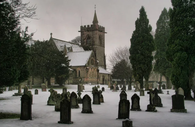
St Lawrence's Church, Crosby Ravensworth
Historic churches · 3.2 km

Millenium Stone
Public art & sculpture · 3.3 km

Crosby Ravensworth
Other places · 3.4 km

Midtown Farm Camping & Caravan Site
Caravan parks · 3.5 km

Hardendale
Other places · 3.6 km

Crosby Ravensworth Pinfold
Public art & sculpture · 3.7 km
Nearby
📷 3📷 3Historic houses · North East England
Crake Trees tower house
Crake Trees tower house — a Grade II-listed historic house in england-north-east, United Kingdom.
📷 4National parks · North East England
Maulds Meaburn
Maulds Meaburn in England North East, United Kingdom.
📷 3Archaeological sites · North West England
Iron Hill North Circle
Iron Hill North Circle — a archaeological in england-north-east, United Kingdom.
📷 3📷 4Where to eat & stay near Reagill
Places to stay
📷 5Caravan parks · North East England
Midtown Farm Camping & Caravan Site
Midtown Farm Camping & Caravan Site — a caravan park in england north east.
 📷 5
📷 5Caravan parks · North West England
Newby End Farm Caravan Site
Newby End Farm Caravan Site — a caravan park in england north east.
 📷 5
📷 5Campsites · North West England
New Ing Lodge Camping
New Ing Lodge Camping — a campsite in england north east.
📷 5Hostels · North West England
New Ing Lodge
New Ing Lodge — a hostel in england north east.
 📷 5
📷 5Caravan parks · North West England
Highgate Holiday Park
Highgate Holiday Park — a caravan park in england north east.
 📷 5
📷 5Campsites · North West England
Greengill Campsite
Greengill Campsite — a campsite in england north east.
Places to eat & drink
 📷 5
📷 5Historic pubs · North East England
1, Scattergate
1, Scattergate in England North East, United Kingdom.
 📷 7
📷 7Historic pubs · North West England
Two Lions public house and integral stables
Two Lions public house and integral stables in Scotland Lowlands, United Kingdom.
 📷 6
📷 6Historic pubs · North West England
Gloucester Arms
Gloucester Arms in Scotland Lowlands, United Kingdom.
 📷 7
📷 7Cafés · North West England
Narrowbar Cafe
Narrowbar Cafe — a café in scotland lowlands.
 📷 3
📷 3 📷 5
📷 5Historic pubs · North West England
Horse And Farrier Inn And Stables
Horse And Farrier Inn And Stables in Scotland Lowlands, United Kingdom.
More places in this region
 📷 5
📷 5Other places · North West England
Anderton with Marbury
Anderton with Marbury — a other in england-west-midlands, United Kingdom.
 📷 5
📷 5Other places · North West England
Baddington
Baddington — a other in england-west-midlands, United Kingdom.
 📷 5
📷 5Other places · North West England
Latchford, Cheshire
Latchford, Cheshire — a other in england-west-midlands, United Kingdom.
 📷 5
📷 5Other places · North West England
Ringway, Manchester
Ringway, Manchester — a other in england-west-midlands, United Kingdom.
Frequently asked questions
- Where is Reagill?
- Reagill is in North-West England, United Kingdom (postcode CA10 3ER), in the parish of Crosby Ravensworth.
- What is Reagill?
- Reagill in England North East, United Kingdom.
- How do I get to Reagill?
- The nearest railway station is Appleby, about 8.8 km away. The nearest town is Newby. Drivers can use postcode CA10 3ER.
- Is Reagill a protected site?
- Yes — Reagill is part of the River Eden and Tributaries SSSI Site of Special Scientific Interest and the North Pennines National Landscape (AONB).
- How do I get to Reagill?
- Drivers can navigate to postcode CA10 3ER. It sits within the Westmorland and Lonsdale parliamentary constituency.