
Reservoirs & lochs · Central Scotland
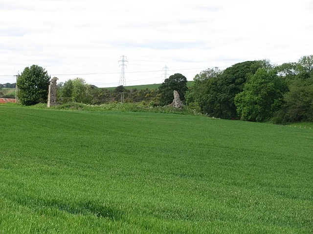
Raith, Fife
In or near Auchtertool.
Raith, Fife in Scotland Islands, United Kingdom.

James Allan — CC BY-SA 2.0 via Wikimedia Commons licence

Plan your visit
- Typical visit
- 1 h–2.5 h
- Nearest railway station
- Cardenden · 3.8 km
- Free entry
- Dog-friendly
Getting there & planning your visit
To visit Raith in Fife, the nearest railway station is Cardenden, located 3.8 km away. The postcode for sat-nav is KY2 5YA, and entry to the reservoir is free.
About
Raith, Fife is a place of interest in Scotland Islands, United Kingdom — drawn from open-data sources for visitor reference. See the linked Wikipedia article for the full description.
Photo gallery
From the Wikipedia article
Raith (Scottish Gaelic: ràth, "fort" or "fortified residence"), as an area of Fife, once stretched from the lands of Little Raith (earlier Wester Raith), south of Loch Gelly, as far as Kirkcaldy and the Battle of Raith was once theorised to have been fought here in 596 AD. Raith Hill, west of Auchtertool and immediately to the east of the Mossmorran fractionation plant, may also be in reference to this wider area or may refer to an actual fort on this hill, distinct to the one naming the area. The name is found in Kirkcaldy's professional football team, Raith Rovers. This name was earlier borne by an entirely distinct team, probably named for the Little Raith colliery, east of Cowdenbeath, which merged with Cowdenbeath Rangers to form Cowdenbeath F. C. Raith House and the 19th-century folly Raith Tower sit on Cormie Hill to the west of Kirkcaldy. The former was designed by James Smith in the Palladian style in the 1690s, remodelled and extended by James Playfair in the 1780s and the library and garden remodelled in 1899 by Robert Lorimer. To the southeast, the artificial Raith Lake was formed by the damming of the Dronachy Burn in 1811 and 1812. From the late nineteenth century onwards, tracts of land of the Raith Estate were sold off and developed for housing and to form the town's Beveridge Park, expanding Kirkcaldy westwards. The modern housing estate bearing the Raith name dates from the latter part of the 20th century, long after the origins of the football team.
Excerpt from Wikipedia under CC BY-SA 4.0. See the source article linked in Sources below.
- Coordinates
- 56.1100, -3.2350
- District
- Fife
- Postcode
- KY2 5YA
- Parliamentary constituency
- Cowdenbeath and Kirkcaldy
- Nearest railway station
- Cardenden — 3.8 km
Sources
- wikidata: Q24197241 (CC0)
- wikipedia: Raith, Fife (CC BY-SA 4.0)
Other places nearby
Diana's Fountain
Waterfalls · 0.9 km

Camilla Loch
Lakes · 1.2 km

Auchtertool
Towns & cities · 1.4 km

Mourn House
Historic houses · 1.5 km
Lambert's Mill Bridge
Historic bridges · 1.6 km
Damhead
Historic houses · 1.6 km

Cormie Hill
Mountains & hills · 1.7 km

Raith Tower, Comrie Hill, Raith Estate
Memorials & monuments · 1.7 km

Croupie Craigs Bridge
Historic bridges · 1.7 km

Shawsmill Bridge
Historic bridges · 1.8 km

Balmuto Bridge
Historic bridges · 2.1 km
Hallyards Palace
Castles · 2.1 km
Nearby
📷 5📷 5📷 3Historic houses · Central Scotland
Mourn House
Mourn House — a historic house in scotland-central, United Kingdom.
📷 5Historic bridges · Central Scotland
Lambert's Mill Bridge
Lambert's Mill Bridge — category C listed building-listed bridge in scotland-central, United Kingdom.
📷 3Historic houses · Central Scotland
Damhead
Damhead — a historic house in scotland-central, United Kingdom.
Where to eat & stay near Raith, Fife
Places to stay
 📷 5
📷 5Hotels · Central Scotland
Oswald House Hotel
Oswald House Hotel — a hotel in scotland central.
 📷 5
📷 5B&Bs · Central Scotland
Links Guest House
Links Guest House — a bed-and-breakfast in scotland central.
 📷 5
📷 5Caravan parks · Central Scotland
Pettycur Bay Holiday Park
Pettycur Bay Holiday Park — a caravan park in scotland central.
 📷 5
📷 5Caravan parks · Central Scotland
Sandhills Caravan Park
Sandhills Caravan Park — a caravan park in scotland central.
 📷 5
📷 5Caravan parks · Central Scotland
Kinghorn Harbour Holiday Park
Kinghorn Harbour Holiday Park — a caravan park in scotland central.
 📷 7
📷 7Places to eat & drink
 📷 5
📷 5Historic pubs · Central Scotland
The Robert Nairn
The Robert Nairn in Scotland Central, United Kingdom.
 📷 7
📷 7Historic pubs · Central Scotland
The Royal Scot, 395-399 High Street, Kirkcaldy
The Royal Scot, 395-399 High Street, Kirkcaldy in Scotland Central, United Kingdom.
 📷 7
📷 7Historic pubs · Central Scotland
461 and 463 High Street, Kirkcaldy
461 and 463 High Street, Kirkcaldy in Scotland Central, United Kingdom.
 📷 5
📷 5Historic pubs · Central Scotland
Feuars Arms, 66-68 Commercial Street, Kirkcaldy
Feuars Arms, 66-68 Commercial Street, Kirkcaldy in Scotland Central, United Kingdom.
 📷 5
📷 5Historic pubs · Central Scotland
The Star Tavern, 71-73 High Street, Burntisland
The Star Tavern, 71-73 High Street, Burntisland in Scotland Central, United Kingdom.
 📷 7
📷 7Historic pubs · Central Scotland
Belvedere Hotel, West Wemyss
Belvedere Hotel, West Wemyss in Scotland Central, United Kingdom.
More places in this region
 📷 5
📷 5 📷 3
📷 3Reservoirs & lochs · Central Scotland
Allt na Lairige Reservoir
Allt na Lairige Reservoir — 1956 artificial lake in Argyll and Bute, Scotland, UK, on and outflowing west to Allt na Lairige.
.jpg?width=1200) 📷 3
📷 3Reservoirs & lochs · Central Scotland
Ardlussa Fishing Loch
Ardlussa Fishing Loch — 1900 artificial lake on Jura, Argyll and Bute, Scotland, UK, on the Lussa River.
 📷 3
📷 3Reservoirs & lochs · Central Scotland
Asgog Loch
Asgog Loch — lake dammed as a reservoir in Argyll and Bute, Scotland, UK, outflows east via a watercourse to Allt Osda.
Frequently asked questions
- Where is Raith, Fife?
- Raith, Fife is in the Scottish Highlands, United Kingdom (postcode KY2 5YA).
- What is Raith, Fife?
- Raith, Fife in Scotland Islands, United Kingdom.
- How do I get to Raith, Fife?
- The nearest railway station is Cardenden, about 3.8 km away. Drivers can use postcode KY2 5YA.
- Is Raith, Fife free to visit?
- Yes, Raith, Fife is free to enter.
- How do I get to Raith, Fife?
- The nearest railway station is Cardenden, about 3.8 km away. Drivers can navigate to postcode KY2 5YA.