
Memorials & monuments · South West England
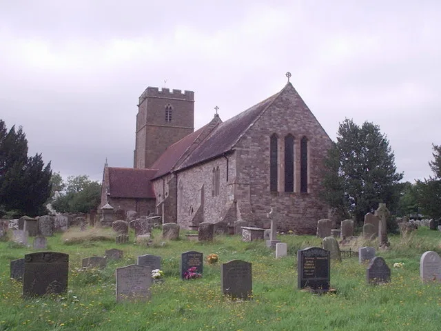
Raisher And Unidentified Monument, About 17M South-South-East Of Tower In Churchyard Of Church Of St Mary
In or near Newnham.
Raisher And Unidentified Monument, About 17M South-South-East Of Tower In Churchyard Of Church Of St Mary — Grade II listed building-listed memorial in england-west-midlands, United Kingdom.

Sarah Charlesworth — CC BY-SA 2.0 via Wikimedia Commons licence

Plan your visit
- Typical visit
- 15 min–45 min
- Nearest railway station
- Parkend · 9.3 km
- Free entry
- Dog-friendly
Getting there & planning your visit
To visit the Raisher And Unidentified Monument, the nearest railway station is Parkend, located 9.3 km away. The postcode for the site is GL2 7JL, and entry is free. Accessibility information is not provided.
About
Raisher And Unidentified Monument, About 17M South-South-East Of Tower In Churchyard Of Church Of St Mary is a Grade II listed building-listed memorial in england-west-midlands, United Kingdom, registered on the National Heritage List for England (NHLE entry 1090578). Listed status protects buildings and structures of special architectural or historic interest. See the linked Wikipedia article for further details.
Photo gallery
See it from the streetimagery from 2020
Imagery © Mapillary contributors, CC BY-SA 4.0
Heritage listing
Details ARLINGHAM CHURCH ROAD SO 71 SW (west side) 2/17 Raisher and Unidentified Monument, about 17m south-south-east of tower in churchyard of Church of St. Mary GV II Chest and railed pedestal tomb. From north to south: pedestal tomb to Raisher family, 1798 earliest; unidentified chest tomb, probably mid C18. Raisher - Forest limestone, stepped cap with urn-like finial on flat top, tall plain plinth, on base with tall spearhead railings and corner urns. Square with unfluted corner columns, pointed arch panels with colonnette jambs and cherubs' heads in spandrels to each side, but all different. Unidentified - limestone, flat top, moulded plinth and capping. Gadrooned quarter balusters, recessed end panels with urn to west and torch to east, relief cartouche to north side and raised oval to south with carved surround. Listing NGR: SO7065310641 Legacy The contents of this record have been generated from a legacy data system. Legacy System number: 132275 Legacy System: LBS
From the Historic England List Entry under OGL v3.
Protected designations
- Area of Outstanding Natural Beauty: Cotswolds
Designations sourced from Natural England open data under OGL v3.
Place summary
Raisher and Unidentified Monument is a Grade II listed memorial located approximately 17 metres south-south-east of the tower in the churchyard of the Church of St Mary in Arlingham, Gloucestershire. This structure contributes to the historical landscape of the West Midlands.
AI-generated from the structured facts on this page (operator, designation, listing, era). Not a substitute for visiting.
- Coordinates
- 51.7936, -2.4269
- County
- Gloucestershire
- District
- Stroud
- Parish
- Arlingham
- Postcode
- GL2 7JL
- Parliamentary constituency
- Stroud
- Nearest railway station
- Parkend — 9.3 km
Sources
- wikidata: Q26380784 (CC0)
Other places nearby

Church of St Mary
Historic churches · 0.0 km

Three Hodges Monuments, About 7-11M South Of South-East Nave Buttress In Churchyard Of Church Of St Mary
Memorials & monuments · 0.0 km

Vimpany And Two Longney Monuments About 15-22M South-East Of Tree Hodges Monuments In Churchyard Of Church Of St Mary
Memorials & monuments · 0.0 km
Unidentified Monument, About 10m East Of Chancel In Churchyard Of Church Of St Mary
Memorials & monuments · 0.1 km
Hodges Carter Monument, About 14M North-East Of North-East Chancel Buttress In Churchyard Of Church Of St Mary
Memorials & monuments · 0.1 km

Saint Augustines Working Farm
Historic churches · 0.5 km

Newnham on Severn Castle House
Literary houses · 1.9 km

Millennium Marker
Public art & sculpture · 1.9 km

Newnham
Towns & cities · 1.9 km

Severn Valley Touring Caravan and Camping
Campsites · 2.2 km

Barrow Hill
Mountains & hills · 2.4 km
Church of St Andrew
Historic churches · 2.6 km
Nearby
📷 3Historic churches · South West England
Church of St Mary
Church of St Mary — church in Arlingham Gloucestershire, England, UK.
📷 3Memorials & monuments · South West England
Three Hodges Monuments, About 7-11M South Of South-East Nave Buttress In Churchyard Of Church Of St Mary
Three Hodges Monuments, About 7-11M South Of South-East Nave Buttress In Churchyard Of Church Of St Mary — Grade II listed building-listed memorial in england-west-midlands, United Kingdom.
📷 3Memorials & monuments · South West England
Vimpany And Two Longney Monuments About 15-22M South-East Of Tree Hodges Monuments In Churchyard Of Church Of St Mary
Vimpany And Two Longney Monuments About 15-22M South-East Of Tree Hodges Monuments In Churchyard Of Church Of St Mary — Grade II listed building-listed memorial in england-west-midlands, United Kingdo
📷 3Memorials & monuments · South West England
Unidentified Monument, About 10m East Of Chancel In Churchyard Of Church Of St Mary
Unidentified Monument, About 10m East Of Chancel In Churchyard Of Church Of St Mary — Grade II listed building-listed memorial in england-west-midlands, United Kingdom.
📷 3Memorials & monuments · South West England
Hodges Carter Monument, About 14M North-East Of North-East Chancel Buttress In Churchyard Of Church Of St Mary
Hodges Carter Monument, About 14M North-East Of North-East Chancel Buttress In Churchyard Of Church Of St Mary — Grade II listed building-listed memorial in england-west-midlands, United Kingdom.
📷 3Historic churches · South West England
Saint Augustines Working Farm
Saint Augustines Working Farm — a other in england-west-midlands, United Kingdom.
Where to eat & stay near Raisher And Unidentified Monument, About 17M South-South-East Of Tower In Churchyard Of Church Of St Mary
Places to stay
📷 5Campsites · South West England
Severn Valley Touring Caravan and Camping
Severn Valley Touring Caravan and Camping — a campsite in england west midlands.
 📷 7
📷 7 📷 5
📷 5Caravan parks · South West England
Enfield Park
Enfield Park — a caravan park in england west midlands.
 📷 5
📷 5Campsites · South West England
The Christian Adventure Centre at Viney Hill
The Christian Adventure Centre at Viney Hill — a campsite in england west midlands.
 📷 5
📷 5 📷 5
📷 5Campsites · South West England
Tudor Caravan Park
Tudor Caravan Park — a campsite in england west midlands.
Places to eat & drink
 📷 5
📷 5Historic pubs · South West England
The Red Hart (Public House)
The Red Hart (Public House) in England South East, United Kingdom.
 📷 6
📷 6Historic pubs · South West England
The Yew Tree (Public House)
The Yew Tree (Public House) in England South East, United Kingdom.
 📷 7
📷 7Historic pubs · South West England
King's Head Hotel
King's Head Hotel in England South East, United Kingdom.
 📷 5
📷 5Historic pubs · South West England
Berkeley Arms, Purton
Berkeley Arms, Purton in England South East, United Kingdom.
 📷 5
📷 5Historic pubs · South West England
The White Lion
The White Lion in England South East, United Kingdom.
 📷 7
📷 7Cafés · South West England
The Lazy Goose
The Lazy Goose — a café in england west midlands.
More memorials in this region
 📷 5
📷 5Memorials & monuments · South West England
Bath Cenotaph
Bath Cenotaph is a memorial in the United Kingdom.
 📷 5
📷 5Memorials & monuments · South West England
Cross of Sacrifice
Cross of Sacrifice is a memorial in the United Kingdom.
 📷 5
📷 5Memorials & monuments · South West England
Grange Arch
Grange Arch is a memorial in the United Kingdom.
.jpg?width=1200) 📷 5
📷 5Memorials & monuments · South West England
King Alfred Memorial
King Alfred Memorial is a memorial in the United Kingdom.
Frequently asked questions
- Where is Raisher And Unidentified Monument, About 17M South-South-East Of Tower In Churchyard Of Church Of St Mary?
- Raisher And Unidentified Monument, About 17M South-South-East Of Tower In Churchyard Of Church Of St Mary is in Gloucestershire, the West Midlands, United Kingdom (postcode GL2 7JL), in the parish of Arlingham.
- What is Raisher And Unidentified Monument, About 17M South-South-East Of Tower In Churchyard Of Church Of St Mary?
- Raisher And Unidentified Monument, About 17M South-South-East Of Tower In Churchyard Of Church Of St Mary — Grade II listed building-listed memorial in england-west-midlands, United Kingdom.
- How do I get to Raisher And Unidentified Monument, About 17M South-South-East Of Tower In Churchyard Of Church Of St Mary?
- The nearest railway station is Parkend, about 9.3 km away. Drivers can use postcode GL2 7JL.
- Is Raisher And Unidentified Monument, About 17M South-South-East Of Tower In Churchyard Of Church Of St Mary a listed building?
- Raisher And Unidentified Monument, About 17M South-South-East Of Tower In Churchyard Of Church Of St Mary is officially recognised as Grade II listed building listed.
- Is Raisher And Unidentified Monument, About 17M South-South-East Of Tower In Churchyard Of Church Of St Mary a protected site?
- Yes — Raisher And Unidentified Monument, About 17M South-South-East Of Tower In Churchyard Of Church Of St Mary is part of the Cotswolds National Landscape (AONB).
- Is Raisher And Unidentified Monument, About 17M South-South-East Of Tower In Churchyard Of Church Of St Mary free to visit?
- Yes, Raisher And Unidentified Monument, About 17M South-South-East Of Tower In Churchyard Of Church Of St Mary is free to enter.
- How do I get to Raisher And Unidentified Monument, About 17M South-South-East Of Tower In Churchyard Of Church Of St Mary?
- Drivers can navigate to postcode GL2 7JL. It sits within the Stroud parliamentary constituency.