
Museums · South West England
Radstock
In or near Shoscombe.
Radstock is a town and civil parish on the northern slope of the Mendip Hills in Somerset, England, about 9 miles (14 km) south-west of Bath and 8 miles (13 km) north-west of Frome. It is within the a

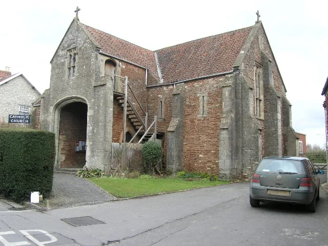
Jonathan Thacker — CC BY-SA 2.0 via Wikimedia Commons licence

Plan your visit
- Typical visit
- 1.5 h–3 h
- Best time of year
- Year-round
- Nearest railway station
- Midsomer Norton · 2.8 km
- Paid entry
- Family-friendly
- Limited wheelchair access
Getting there & planning your visit
To visit Radstock Museum, the nearest railway station is Midsomer Norton, located 2.8 km away. The postcode for the museum is BA3 3EP. Entry is free, but please note that wheelchair accessibility is limited.
About
Radstock is a town and civil parish on the northern slope of the Mendip Hills in Somerset, England, about 9 miles (14 km) south-west of Bath and 8 miles (13 km) north-west of Frome. It is within the area of the unitary authority of Bath and North East Somerset. At the 2021 census, the parish had a population of 6,149, and the built-up area as defined by the Office for National Statistics, which extends into the neighbouring parish of Westfield, had a population of 9,980. Radstock has been settled since the Iron Age, and its importance grew after the construction of the Fosse Way, a Roman road. The town grew after 1763, when coal was discovered in the area. Large numbers of mines opened during the 19th century, including several owned by the Waldegrave family, who had been Lords of the Manor since the Civil War. Admiral Lord Radstock, brother of George, fourth Earl Waldegrave, took the town's name as his title when created a Baron. The spoil heap of Writhlington colliery is now the Writhlington Site of Special Scientific Interest, which includes 3,000 tons of Upper Carboniferous spoil from which more than 1,400 insect fossil specimens have been recovered. The complex geology and narrow seams made coal extraction difficult. Tonnage increased throughout the 19th century, reaching a peak around 1901, when there were 79 separate collieries and annual production was 1,250,000 tons per annum. However, due to local geological difficulties and manpower shortages, output declined and t
Photo gallery
See it from the streetimagery from 2026
Imagery © Mapillary contributors, CC BY-SA 4.0
Official information
Radstock Museum showcases the rich industrial heritage of the Radstock area, particularly its coal mining history. Visitors can explore various exhibits and displays that highlight local history and culture.
From the Wikipedia article
Radstock is a town and civil parish on the northern slope of the Mendip Hills in Somerset, England, about 9 miles (14 km) south-west of Bath and 8 miles (13 km) north-west of Frome. It is within the area of the unitary authority of Bath and North East Somerset. At the 2021 census, the parish had a population of 6,149, and the built-up area as defined by the Office for National Statistics, which extends into the neighbouring parish of Westfield, had a population of 9,980. Radstock has been settled since the Iron Age, and its importance grew after the construction of the Fosse Way, a Roman road. The town grew after 1763, when coal was discovered in the area. Large numbers of mines opened during the 19th century, including several owned by the Waldegrave family, who had been Lords of the Manor since the Civil War. Admiral Lord Radstock, brother of George, fourth Earl Waldegrave, took the town's name as his title when created a Baron. The spoil heap of Writhlington colliery is now the Writhlington Site of Special Scientific Interest, which includes 3,000 tons of Upper Carboniferous spoil from which more than 1,400 insect fossil specimens have been recovered. The complex geology and narrow seams made coal extraction difficult. Tonnage increased throughout the 19th century, reaching a peak around 1901, when there were 79 separate collieries and annual production was 1,250,000 tons per annum. However, due to local geological difficulties and manpower shortages, output declined and the number of pits reduced from 30 at the beginning of the 20th century to 14 by the mid-thirties; the last two pits, Kilmersdon and Writhlington, closed in September 1973. Manufacturing industries such as printing, binding and packaging provide some local employment. In recent years, Radstock has increasingly become a commuter town for the cities of Bath and Bristol. Radstock is home to the Radstock Museum which is housed in a former market hall, and has a range of exhibits which offer an insigh
Excerpt from Wikipedia under CC BY-SA 4.0. See the source article linked in Sources below.
Background
History
Radstock has been settled since the Iron Age. Its importance grew with the construction of the Fosse Way, the Roman road that ran along what is now part of the A367 in Radstock. As a result, the town was known as Stoche at the time of the Domesday Book of 1086, meaning the stockade by the Roman road, from the Old English stoc. The rad part of the name is believed to relate to red; the soil locally is reddish marl. The parish of Radstock was part of the Kilmersdon Hundred, The Great Western Railway, and the Somerset and Dorset Railway, established stations and marshalling yards in the town. Radstock was the terminus for the southern branch of the Somerset Coal Canal, which was turned into a…
Sourced from Wikipedia under CC BY-SA 4.0.
- Coordinates
- 51.2930, -2.4480
- District
- Bath and North East Somerset
- Parish
- Radstock
- Postcode
- BA3 3EP
- Parliamentary constituency
- Frome and East Somerset
- Phone
- ++44 (0)1761 437722
- Nearest railway station
- Midsomer Norton — 2.8 km
- Official site
- radstockmuseum.co.uk
Sources
- wikipedia: Radstock (CC BY-SA 4.0)
Other places nearby

Colliery Wheel
Memorials & monuments · 0.0 km
Radstock Museum
Museums · 0.0 km

The Radstock Hotel
Hotels · 0.1 km
Radstock War Memorial
Memorials & monuments · 0.1 km

River Somer
Museums · 0.1 km

Radstock Round Hill
Castles · 1.2 km

Haydon Hill
Mountains & hills · 1.4 km

Fir Tree Inn
Historic pubs · 1.4 km

Roman temple in Camerton
Follies · 1.4 km
Church of the Holy Ghost, Midsomer Norton
Historic churches · 2.4 km

Palladium
Theatres · 2.4 km
Midsomer Norton War Memorial
Memorials & monuments · 2.4 km
Nearby
📷 5Memorials & monuments · South West England
Colliery Wheel
Colliery Wheel — a memorial in england-south-east, United Kingdom.
📷 5Museums · South West England
Radstock Museum
Radstock Museum — a museum in england-south-east, United Kingdom.
📷 5Hotels · South West England
The Radstock Hotel
The Radstock Hotel — a hotel in england south east.
📷 5Memorials & monuments · South West England
Radstock War Memorial
Radstock War Memorial — Grade II listed building-listed memorial in england-south-east, United Kingdom.
📷 5Museums · South West England
River Somer
River Somer — a museum in england-south-east, United Kingdom.
📷 5Castles · South West England
Radstock Round Hill
Radstock Round Hill — a castle in england south east.
Where to eat & stay near Radstock
Places to stay
📷 5Hotels · South West England
The Radstock Hotel
The Radstock Hotel — a hotel in england south east.
 📷 5
📷 5B&Bs · South West England
The Old Priory
The Old Priory — a bed-and-breakfast in england south east.
 📷 5
📷 5Campsites · South West England
Old Mills Campsite
Old Mills Campsite — a campsite in england south west.
 📷 5
📷 5Caravan parks · South West England
Old Down Touring Park
Old Down Touring Park — a caravan park in england south west.
 📷 5
📷 5 📷 5
📷 5Campsites · South West England
Centenary Wood Campsite
Centenary Wood Campsite — a campsite in england south east.
Places to eat & drink
📷 7 📷 7
📷 7Historic pubs · South West England
The Jolliffe Arms And Nos 235 And 236
The Jolliffe Arms And Nos 235 And 236 in England South West, United Kingdom.
 📷 5
📷 5Historic pubs · South West England
Apple Tree Inn
Apple Tree Inn in England South West, United Kingdom.
 📷 7
📷 7 📷 7
📷 7Historic pubs · South West England
Fox And Badger Public House
Fox And Badger Public House in England South West, United Kingdom.
 📷 5
📷 5Historic pubs · South West England
The Wheatsheaf
The Wheatsheaf in England South West, United Kingdom.
More museums in this region
 📷 5
📷 5Museums · South West England
Alexander Keiller Museum
Alexander Keiller Museum — museum in South West England, United Kingdom.
 📷 5
📷 5Museums · South West England
American Museum and Gardens
American Museum and Gardens — culture and arts museum near Bath, England, United Kingdom.
 📷 5
📷 5Museums · South West England
Atwell-Wilson Motor Museum
Atwell-Wilson Motor Museum — museum in Calne, England, UK.
 📷 5
📷 5Museums · South West England
Bath Abbey Heritage Vaults
Bath Abbey Heritage Vaults — museum in Bath Abbey, Bath, England, UK.
Frequently asked questions
- Where is Radstock?
- Radstock is in South-West England, United Kingdom (postcode BA3 3EP), in the parish of Radstock.
- What is Radstock?
- Radstock is a town and civil parish on the northern slope of the Mendip Hills in Somerset, England, about 9 miles (14 km) south-west of Bath and 8 miles (13 km) north-west of Frome. It is within the a
- How do I get to Radstock?
- The nearest railway station is Midsomer Norton, about 2.8 km away. The nearest town is Shoscombe. Drivers can use postcode BA3 3EP.
- How do I get to Radstock?
- The nearest railway station is Midsomer Norton, about 2.8 km away. Drivers can navigate to postcode BA3 3EP.