Islands · Scottish Highlands
Q25635068
Q25635068 is a island in the United Kingdom.

Wikimedia Commons contributors — see linked file page for photographer and licence licence
Plan your visit
- Typical visit
- 4 h–12 h
- Free entry
- Dog-friendly
About
Q25635068 is a island in the United Kingdom. Coordinates: 58.1000°, -6.4833°. This entry is part of The Great Britain Guide, a free, ad-free, open-data tourist directory.
Place summary
Q25635068 is an island located in the Scottish Highlands, within the postcode HS2. Its specific historical or geographical significance is not detailed in the provided information.
AI-generated from the structured facts on this page (operator, designation, listing, era). Not a substitute for visiting.
- Coordinates
- 58.1000, -6.4833
- District
- Na h-Eileanan Siar
- Postcode
- HS2 9JT
- Parliamentary constituency
- Na h-Eileanan an Iar
Sources
- wikidata: Q25635068 (CC0)
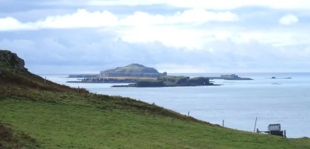
- commons: The Harbour at Cèos - geograph.org.uk - 9706.jpg (CC BY-SA 4.0)
Other places nearby
Loading nearby places…
Nearby
 📷 3
📷 3Reservoirs & lochs · Scottish Islands
Ceòs
Ceòs in Scotland Islands, United Kingdom.
 📷 3
📷 3Reservoirs & lochs · Scottish Islands
Loch Erisort
Loch Erisort in Scotland Islands, United Kingdom.
 📷 3
📷 3Memorials & monuments · Scottish Highlands
Kinloch War Memorial
Kinloch War Memorial — a memorial in scotland-highlands, United Kingdom.
Hostels · Scottish Highlands
Ravenspoint
Ravenspoint — a hostel in scotland highlands.
📷 3Museums · Scottish Highlands
Ravenspoint Museum
Ravenspoint Museum — a museum in scotland-highlands, United Kingdom.
📷 3Memorials & monuments · Scottish Highlands
Pairc War Memorial
Pairc War Memorial — a memorial in scotland-highlands, United Kingdom.
More places in this region
 📷 5
📷 5Islands · Scottish Highlands
Bac Beag
Bac Beag — Scottish island, part of the Treshnish Isles in the Inner Hebrides.
 📷 5
📷 5Islands · Scottish Highlands
Bac Mòr
Bac Mòr — island in Argyll and Bute, Scotland, UK, one of the Treshnish Isles.
 Flagship📷 3
Islands · Scottish Highlands
Baleshare
Baleshare — flat tidal island in the Outer Hebrides, Scotland, UK.
 Flagship📷 5
Islands · Scottish Highlands
Barra
Barra — island in Outer Hebrides, Scotland, UK.
Frequently asked questions
- Where is Q25635068?
- Q25635068 is in the Scottish Highlands, United Kingdom (postcode HS2 9JT).
- Is Q25635068 free to visit?
- Yes, Q25635068 is free to enter.
- How do I get to Q25635068?
- Drivers can navigate to postcode HS2 9JT. It sits within the Na h-Eileanan an Iar parliamentary constituency.