Harbours & ports · South Wales
Port of Port Talbot
Port of Port Talbot is a harbour in the United Kingdom.

Wikimedia Commons contributors — see linked file page for photographer and licence licence
Plan your visit
- Typical visit
- 45 min–1.5 h
- Nearest railway station
- Port Talbot Parkway · 0.7 km
- Family-friendly
- Dog-friendly
About
Port of Port Talbot is a harbour in the United Kingdom. Records date its origin to 1837. Owned by Associated British Ports. Coordinates: 51.5867°, -3.7861°.
Photo gallery
From the Wikipedia article
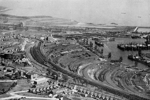
The Port of Port Talbot is located on the River Afan estuary next to Port Talbot Steelworks in the industrial town of Port Talbot, South Wales. The whole basin complex covers about 500 acres (2.0 km2), consisting of: an inner set of floating docks, developed from 1834 onwards; and an outer tidal basin, completed in 1970. Owned and operated by Associated British Ports, the tidal basin has the deepest berthing facilities in the Severn estuary and is one of only a few harbours in the UK capable of handling Capesize vessels of up to 170,000 tonnes deadweight (DWT), mostly for the import of iron ore and coal for use by nearby Port Talbot Steelworks.
Excerpt from Wikipedia under CC BY-SA 4.0. See the source article linked in Sources below.
Background
History
Aberafan had developed as a natural harbour from the 17th century at the mouth of the River Afan, acting as a point of transport for coal and sheep to South Wales, Bristol, and the West Country. From 1750 onwards, tramlines connected the harbour to local coal mines, and the establishment of copper smelting and ironworks towards the end of the 18th century quickly developed volumes of trade. | type = Act | parliament = Parliament of the United Kingdom | long_title = An Act to enable the Port Talbot Company to raise further Monies, and to amend the Acts relating to the same Port. | year = 1840 | citation = 3 & 4 Vict. c. lxxi | introduced_commons = | introduced_lords = | territorial_extent =…
Sourced from Wikipedia under CC BY-SA 4.0.
- Coordinates
- 51.5867, -3.7861
- District
- Neath Port Talbot
- Parish
- Margam Moors
- Postcode
- SA13 1RF
- Parliamentary constituency
- Aberafan Maesteg
- Established
- 1837
- Nearest railway station
- Port Talbot Parkway — 0.7 km
Sources
- wikidata: Q7231235 (CC0)
- wikipedia: Port of Port Talbot (CC BY-SA 4.0)
- commons: Port Talbot Docks - geograph.org.uk - 41571.jpg (CC BY-SA 4.0)
Other places nearby
Loading nearby places…
Nearby
 📷 3
📷 3Theatres · South Wales
New Empire Cinema
New Empire Cinema in Wales South, United Kingdom.
Hostels · South Wales
YMCA
YMCA — a hostel in wales south.
Hotels · South Wales
Grand Hotel
Grand Hotel — a hotel in wales south.
 📷 5
📷 5Historic bridges · South Wales
Plate-Girder Bridge
Plate-Girder Bridge — Grade II listed building-listed bridge in wales-south, United Kingdom.
 📷 5
📷 5Historic churches · South Wales
St Theodore's Church
St Theodore's Church — Grade II* listed building-listed church in wales-south, United Kingdom.
 📷 3
📷 3Memorials & monuments · South Wales
Port Talbot War Memorial
Port Talbot War Memorial is a memorial in the United Kingdom.
Other places from this era
More places in this region
 📷 5
📷 5Harbours & ports · South Wales
Avonmouth
Avonmouth — port, suburb and former electoral ward in Bristol, England.
 📷 3
📷 3Harbours & ports · South Wales
Barry Harbour
Barry Harbour — former harbour in Barry, Vale of Glamorgan.
 📷 5
📷 5Harbours & ports · South Wales
Bristol Harbour
Bristol Harbour — harbour in the city of Bristol, England.
 📷 3
📷 3Harbours & ports · South Wales
Burry Port Harbour
Burry Port Harbour — industrial port for coal industry.
Frequently asked questions
- Where is Port of Port Talbot?
- Port of Port Talbot is in South Wales, United Kingdom (postcode SA13 1RF), in the parish of Margam Moors.
- When was Port of Port Talbot built?
- Built or established in 1837.
- Who owns Port of Port Talbot?
- Port of Port Talbot is owned by Associated British Ports.
- How do I get to Port of Port Talbot?
- The nearest railway station is Port Talbot Parkway, about 0.7 km away. Drivers can navigate to postcode SA13 1RF.