
Wildlife reserves · South East England
Pilsey Island
In or near West Wittering.
Pilsey Island is a wildlife reserve in the United Kingdom.

Wikimedia Commons contributors — see linked file page for photographer and licence licence

Plan your visit
- Typical visit
- 2 h–4 h
- Best time of year
- Autumn & winter (migration & wildfowl)
- Nearest railway station
- Eastoke Corner · 4.6 km
- Free entry
- Dog-friendly
Getting there & planning your visit
To visit Pilsey Island, the nearest railway station is Eastoke Corner, located 4.6 km away. The postcode for navigation is PO10 8DY, and entry to the reserve is free.
About
Pilsey Island is a wildlife reserve in the United Kingdom. Coordinates: 50.8010°, -0.9090°. This entry is part of The Great Britain Guide, a free, ad-free, open-data tourist directory.
Photo gallery
Protected designations
- Site of Special Scientific Interest: Chichester Harbour SSSI
- Area of Outstanding Natural Beauty: Chichester Harbour
- Ramsar wetland: Chichester and Langstone Harbours
Designations sourced from Natural England open data under OGL v3.
From the Wikipedia article
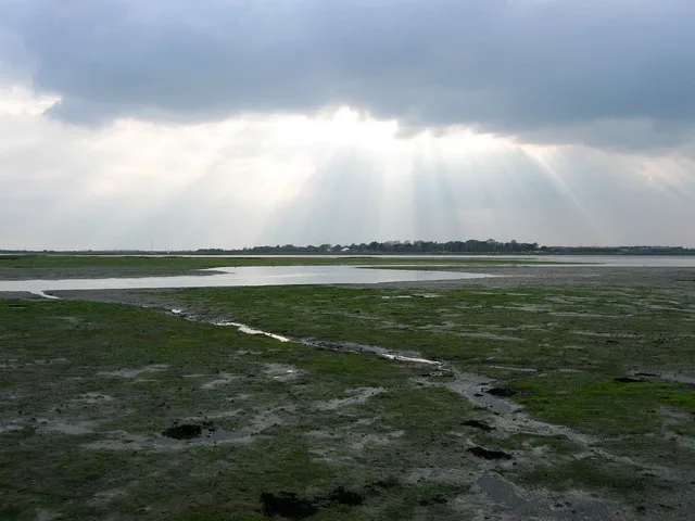
Pilsey Island is a 17.8-hectare (44-acre) Local Nature Reserve in Chichester Harbour in West Sussex. It is owned by the Ministry of Defence and managed by the Royal Society for the Protection of Birds. It is part of the Chichester Harbour Site of Special Scientific Interest and Nature Conservation Review site, Grade I*, the Chichester and Langstone Harbours Ramsar site and Special Protection Area, and the Solent Maritime Special Area of Conservation. The island has sand dunes, mudflats, salt marsh and bare and vegetated shingle. There are many plants, spiders and insects. There is no public access to the site.
Excerpt from Wikipedia under CC BY-SA 4.0. See the source article linked in Sources below.
- Coordinates
- 50.8010, -0.9090
- County
- West Sussex
- District
- Chichester
- Parish
- West Thorney
- Postcode
- PO10 8DY
- Parliamentary constituency
- Chichester
- Nearest railway station
- Eastoke Corner — 4.6 km
Sources
- wikidata: Q65964312 (CC0)
- wikipedia: Pilsey Island (CC BY-SA 4.0)
- commons: Pilsey Island, Chichester Channel - geograph.org.uk - 523019.jpg (CC BY-SA 4.0)
Other places nearby

Chichester Harbour
Harbours & ports · 0.6 km

Chichester Harbour
Harbours & ports · 1.1 km

Rookwood House
Historic houses · 1.6 km

West Thorney
Villages · 1.7 km

The Parish Church of St Nicholas
Historic churches · 1.7 km

Thorney Island
Islands · 2.0 km

Walnut Tree Caravan Park
Caravan parks · 2.0 km

Medieval fish trap. East Head 1.
Archaeological sites · 2.1 km
Medieval fish trap. East Head 2.
Archaeological sites · 2.2 km

Snow Hill Caravan Site
Caravan parks · 2.4 km
Nutborne Marshes
Wildlife reserves · 2.4 km

Sir Henry Royce
Memorials & monuments · 2.4 km
Nearby
📷 5Harbours & ports · South East England
Chichester Harbour
Chichester Harbour — a harbour in england south east.
📷 5Harbours & ports · South East England
Chichester Harbour
Chichester Harbour — Harbour & Site of Special Scientific Interest in Chichester, West Sussex.
📷 5Historic houses · South East England
Rookwood House
Rookwood House — house in West Wittering, Chichester, West Sussex, England, UK.
📷 5📷 5Historic churches · South East England
The Parish Church of St Nicholas
The Parish Church of St Nicholas — a Grade I-listed church in england-south-east, United Kingdom.
📷 5Where to eat & stay near Pilsey Island
Places to stay
📷 5Caravan parks · South East England
Walnut Tree Caravan Park
Walnut Tree Caravan Park — a caravan park in england south east.
📷 5Caravan parks · South East England
Snow Hill Caravan Site
Snow Hill Caravan Site — a caravan park in england south east.
 📷 5
📷 5Caravan parks · South East England
Nunnington Farm Caravan and Camping
Nunnington Farm Caravan and Camping — a caravan park in england south east.
 📷 5
📷 5Caravan parks · South East England
Cobnor House Caravan and Camping
Cobnor House Caravan and Camping — a caravan park in england south east.
 📷 5
📷 5Caravan parks · South East England
Wicks Farm Holiday Park.
Wicks Farm Holiday Park. — a caravan park in england south east.
 📷 5
📷 5Caravan parks · South East England
Camping and Caravanning Club Cobnor
Camping and Caravanning Club Cobnor — a caravan park in england south east.
Places to eat & drink
 📷 7
📷 7Historic pubs · South East England
The Bosham Free House Public House And Restaurant
The Bosham Free House Public House And Restaurant in England South East, United Kingdom.
 📷 7
📷 7Historic pubs · South East England
Sussex Brewery Public House
Sussex Brewery Public House in England South East, United Kingdom.
 📷 7
📷 7Historic pubs · South East England
The Shades Public House
The Shades Public House in England South East, United Kingdom.
 📷 5
📷 5Historic pubs · South East England
The Stag's Head Public House
The Stag's Head Public House in England South East, United Kingdom.
 📷 5
📷 5Historic pubs · South East England
The Good Intent Public House
The Good Intent Public House in England South East, United Kingdom.
 📷 5
📷 5Historic pubs · South East England
The Old House At Home Public House
The Old House At Home Public House in England South East, United Kingdom.
More places in this region
 📷 5
📷 5 📷 5
📷 5Wildlife reserves · South East England
Burham Down
Burham Down — nature reserve in Kent, England, UK.
 📷 5
📷 5Wildlife reserves · South East England
Combe Bottom
Combe Bottom — nature reserve in Surrey, England.
 📷 5
📷 5Wildlife reserves · South East England
Dryhill Nature Reserve
Dryhill Nature Reserve is a wildlife reserve in the United Kingdom.
Frequently asked questions
- Where is Pilsey Island?
- Pilsey Island is in West Sussex, South-East England, United Kingdom (postcode PO10 8DY), in the parish of West Thorney.
- What is Pilsey Island?
- Pilsey Island is a wildlife reserve in the United Kingdom.
- How do I get to Pilsey Island?
- The nearest railway station is Eastoke Corner, about 4.6 km away. The nearest town is West Wittering. Drivers can use postcode PO10 8DY.
- Who owns Pilsey Island?
- Pilsey Island is owned by Royal Society for the Protection of Birds.
- Is Pilsey Island a protected site?
- Yes — Pilsey Island is part of the Chichester Harbour SSSI Site of Special Scientific Interest and the Chichester Harbour National Landscape (AONB).
- Is Pilsey Island free to visit?
- Yes, Pilsey Island is free to enter.
- How do I get to Pilsey Island?
- The nearest railway station is Eastoke Corner, about 4.6 km away. Drivers can navigate to postcode PO10 8DY.
- Are dogs allowed at Pilsey Island?
- Most wildlife reserves allow dogs on lead only, with restrictions during ground-nesting bird season (March-July). Check signage at the reserve.