
Mountains & hills · Mid Wales
Pen y Garn
Pen y Garn — Named summit at 610 m.

Wikimedia Commons contributors — see linked file page for photographer and licence licence

Plan your visit
- Typical visit
- 3 h–8 h
- Best time of year
- Late spring – early autumn (May–Oct)
- Nearest railway station
- Devil's Bridge / Pontarfynach · 6.0 km
- Free entry
- Dog-friendly
Getting there & planning your visit
To visit Pen y Garn, the nearest railway station is Devil's Bridge / Pontarfynach, which is 6 km away. Admission is free. Accessibility details are not provided.
About
Pen y Garn is a named summit in the United Kingdom. Wikidata describes it as: "Named summit at 610 m.". Coordinates: 52.3785°, -3.7667°.
Photo gallery
From the Wikipedia article
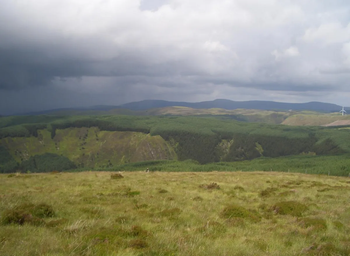
Pen y Garn (head of the cairn) is a mountain in the Cambrian Mountains, Mid Wales standing at 611 metres above sea level. Pen y Garn tops a 500–600 m high plateau, which includes the controversial Cefn Croes wind farm. The summit has a very large shelter cairn hollowed out from the remains of an ancient burial cairn and a trig point. The wind turbines are very near the summit. To the north some 10 km, the whole Plynlimon range can be seen, including the summits of Y Garn, Pen Pumlumon Fawr, Pen Pumlumon Llygad-bychan and Pen Pumlumon Arwystli. 21 km to the west is the town of Aberystwyth; Drygarn Fawr lies 20 km to the SSE .
Excerpt from Wikipedia under CC BY-SA 4.0. See the source article linked in Sources below.
- Coordinates
- 52.3785, -3.7667
- Address
- Ceredigion, Wales
- Nearest railway station
- Devil's Bridge / Pontarfynach — 6 km
Sources
- osm: n1829074116 (ODbL)
- wikipedia: Pen y Garn (CC BY-SA 4.0)
- commons: Penyfagrn.jpg (CC BY-SA 4.0)
Other places nearby
Pen y Garn
Natural landmarks · 0.0 km

Waun Claerddu
Natural landmarks · 0.8 km

Nant Yspryd Glan Deserted Rural Settlement
Vineyards · 1.6 km

Llethr Brith
Historic houses · 1.6 km

Banc Dolwen
Mountains & hills · 1.7 km

Truman
Mountains & hills · 2.1 km

Ffrwd yr Ydfran
Waterfalls · 2.5 km

Cwmystwyth Mines
Memorials & monuments · 2.5 km

Mwyngloddfa Cwmystwyth
Mines & mining heritage · 2.5 km

Y Glog
Mountains & hills · 2.6 km

Lluest Nantycreuau Deserted Rural Settlement
Vineyards · 2.7 km

Ty'n Llechwedd
Historic houses · 2.7 km
Nearby
📷 3📷 3Vineyards · Mid Wales
Nant Yspryd Glan Deserted Rural Settlement
Nant Yspryd Glan Deserted Rural Settlement — a UK vineyard in wales mid, producing English or Welsh wine from cool-climate grape varieties.
📷 3Historic houses · Mid Wales
Llethr Brith
Llethr Brith — a historic house in wales-mid, United Kingdom.
📷 5Mountains & hills · Mid Wales
Banc Dolwen
Banc Dolwen — a mountain in wales-mid, United Kingdom, 537 m.
📷 3Where to eat & stay near Pen y Garn
Places to stay
 📷 5
📷 5Caravan parks · Mid Wales
Tynyffordd Fach Caravan Park
Tynyffordd Fach Caravan Park — a caravan park in wales mid.
 📷 5
📷 5Campsites · Mid Wales
Woodlands Touring Park
Woodlands Touring Park — a campsite in wales mid.
 📷 5
📷 5Caravan parks · Mid Wales
Erwbarfe Farm Caravan Park
Erwbarfe Farm Caravan Park — a caravan park in wales mid.
 📷 5
📷 5Caravan parks · Mid Wales
Woodlands Caravan Park Devils Bridge
Woodlands Caravan Park Devils Bridge — a caravan park in wales mid.
 📷 7
📷 7 📷 7
📷 7Hotels · Mid Wales
George Borrow Hotel
George Borrow Hotel — a hotel in wales mid.
Places to eat & drink
 📷 5
📷 5Cafés · Mid Wales
Llywernog Silver Lead Mine
Llywernog Silver Lead Mine — a café in wales mid.
 📷 5
📷 5 📷 7
📷 7 📷 5
📷 5 📷 5
📷 5Restaurants · Mid Wales
The White Lion Hotel
The White Lion Hotel — a restaurant in wales mid.
 📷 4
📷 4More mountains in this region
 📷 3
📷 3 📷 3
📷 3 📷 3
📷 3 📷 3
📷 3Frequently asked questions
- Where is Pen y Garn?
- Pen y Garn is in Mid Wales, United Kingdom.
- What is Pen y Garn?
- Pen y Garn — Named summit at 610 m.
- How do I get to Pen y Garn?
- The nearest railway station is Devil's Bridge / Pontarfynach, about 6.0 km away. Its coordinates are 52.3785°, -3.7667°.
- Is Pen y Garn free to visit?
- Yes, Pen y Garn is free to enter.
- How do I get to Pen y Garn?
- The nearest railway station is Devil's Bridge / Pontarfynach, about 6.0 km away.