Islands · Scottish Islands
Peerie Bard
Peerie Bard — island in Shetland Islands, Scotland, UK.

Wikimedia Commons contributors — see linked file page for photographer and licence licence
Plan your visit
- Typical visit
- 4 h–12 h
- Free entry
- Dog-friendly
About
Peerie Bard is a island in the United Kingdom. Records date its origin to 1951. Wikidata describes it as: "island in Shetland Islands, Scotland, UK". Coordinates: 59.9981°, -1.1578°.
Photo gallery
From the Wikipedia article
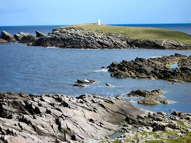
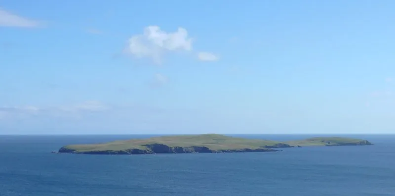
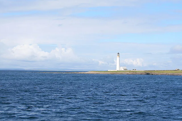
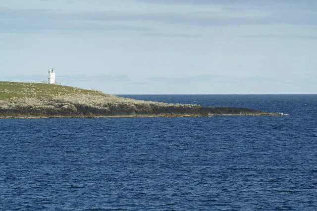
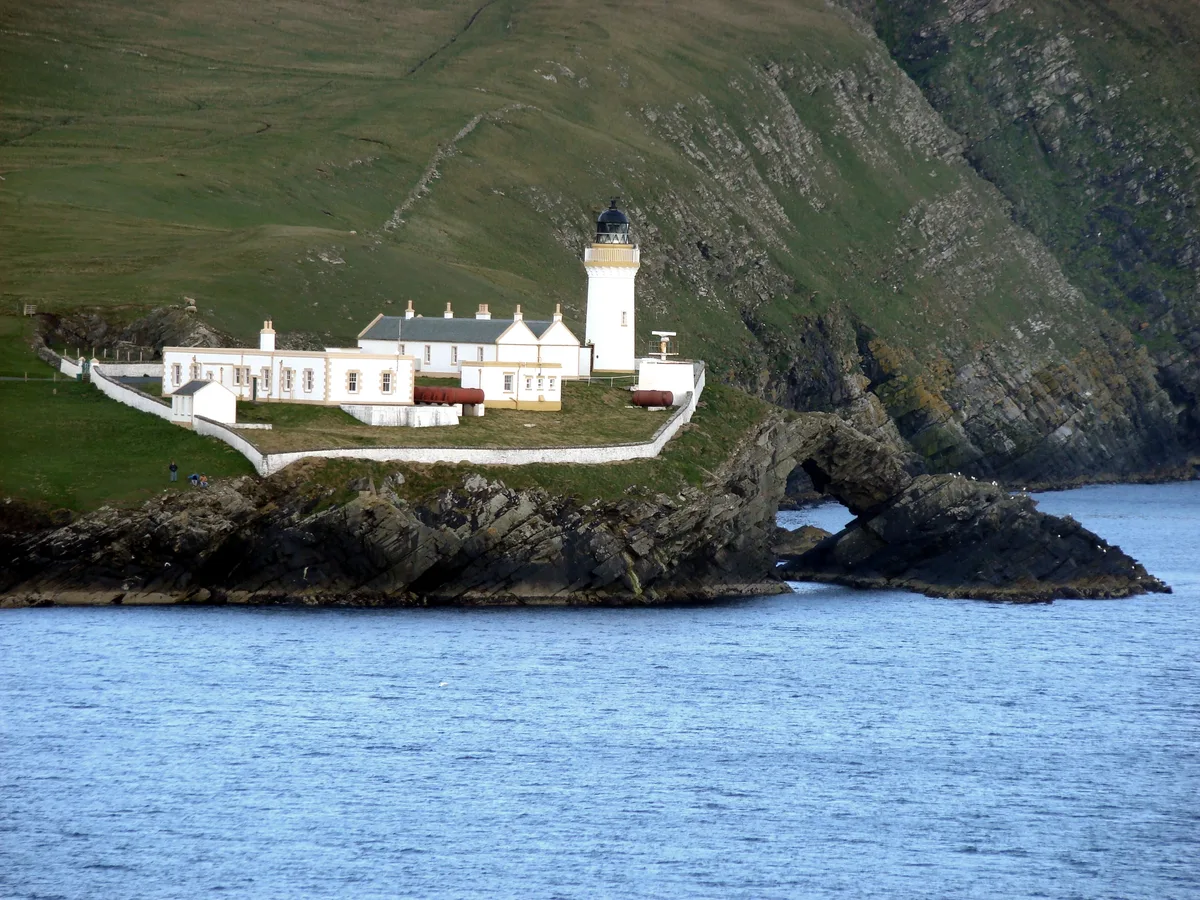
Perie Bard is one of the Shetland Islands. It is a small islet off the east coast of the island of Mousa. Although named 'Perie Bard' on OS Maps, the name used in Shetland is "Peerie Bard". The name is derived from the Shetland dialect words 'Peerie', meaning small, and 'Bard', meaning steep headland. The Muckle Bard, or large steep headland, is located on neighbouring Mousa. The Mousa Lighthouse is located on the Peerie Bard. The lighthouse was first lit in 1951 and replaced one which had previously been located on the nearby headland of Noness
Excerpt from Wikipedia under CC BY-SA 4.0. See the source article linked in Sources below.
- Coordinates
- 59.9981, -1.1578
- Address
- Peerie Bard<br />Mousa<br />Shetland<br />Scotland<br />United Kingdom
- Established
- 1951
Sources
- wikidata: Q7160438 (CC0)
- wikipedia: Peerie Bard (CC BY-SA 4.0)
- commons: Eastern tip of Mousa - geograph.org.uk - 32822.jpg (CC BY-SA 4.0)
Other places nearby
Loading nearby places…
Nearby
 📷 3
📷 3Lighthouses · Scottish Islands
Mousa light station
Mousa light station — lighthouse in Shetland Islands, Scotland, UK.
 Flagship📷 3
Islands · Scottish Islands
Mousa
Mousa — island on the east coast of South Mainland, Shetland Islands, Scotland, UK.
Vineyards · Scottish Islands
Mousa,homestead 570m ENE of Broch of Mousa
Mousa,homestead 570m ENE of Broch of Mousa — a UK vineyard in scotland islands, producing English or Welsh wine from cool-climate grape varieties.
 📷 5
📷 5Memorials & monuments · Scottish Islands
Broch of Mousa
Broch of Mousa in Orkney + Shetland, United Kingdom.
 ★ Iconic📷 3
Archaeological sites · Scottish Islands
Mousa Broch
Shetland's 13m Iron Age broch — the best-preserved in Scotland, 2,000 years old.
 📷 3
📷 3Archaeological sites · Scottish Islands
Burraland, promontory fort
Burraland, promontory fort — a archaeological in scotland-islands, United Kingdom.
Other places from this era
 Flagship📷 5
Islands · Scottish Highlands
Canna
Canna — island in Inner Hebrides, Scotland, UK.
 📷 3
📷 3Islands · Scottish Islands
Little Holm
Little Holm — island in Yell Sound, Shetland Islands, Scotland, UK.
 📷 5
📷 5Islands · Scottish Islands
Muckle Holm
Muckle Holm — island in Yell Sound, Shetland, Scotland, United Kingdom.
More places in this region
 📷 3
📷 3Islands · Scottish Islands
Auskerry
Auskerry — small island in eastern Orkney, Scotland, UK.
 📷 5
📷 5Islands · Scottish Islands
Balta
Balta — island of the Shetland Islands, Scotland, UK, east of Unst.
 📷 3
📷 3Islands · Scottish Islands
Bigga
Bigga — an uninhabited island in the Yell Sound between the Mainland and Yell in Shetland, Scotland.
 📷 5
📷 5Islands · Scottish Islands
Bressay
Bressay — populated island in the Shetland Islands, Scotland, UK.
Frequently asked questions
- Where is Peerie Bard?
- Peerie Bard is in the Scottish Islands, United Kingdom.
- When was Peerie Bard built?
- Built or established in 1951.
- Is Peerie Bard free to visit?
- Yes, Peerie Bard is free to enter.