
Forests & woodlands · East of England
Ouse Washes (Hundred Foot Washes)
In or near Wentworth.
Ouse Washes (Hundred Foot Washes) is a forest or woodland in the United Kingdom.

Wikimedia Commons contributors — see linked file page for photographer and licence licence

Plan your visit
- Typical visit
- 1 h–3 h
- Nearest railway station
- Manea · 7.8 km
- Free entry
- Family-friendly
- Dog-friendly
Getting there & planning your visit
To visit Ouse Washes (Hundred Foot Washes), the nearest railway station is Manea, located 7.8 km away. The postcode for sat-nav is CB6 2FJ, and entry is free.
About
Ouse Washes (Hundred Foot Washes) is a named forest, woodland or nature reserve in the United Kingdom. Coordinates: 52.4311°, 0.1422°.
Photo gallery
Protected designations
- Site of Special Scientific Interest: Ouse Washes SSSI
- Ramsar wetland: Ouse Washes
Designations sourced from Natural England open data under OGL v3.
From the Wikipedia article
Ouse Washes is a linear 2,513.6-hectare (6,211-acre) biological Site of Special Scientific Interest stretching from near St Ives in Cambridgeshire to Downham Market in Norfolk, England. It is also a Ramsar internationally important wetland site, a Special Protection Area for birds, a Special Area of Conservation and a Nature Conservation Review site, Grade I. An area of 186 hectares (460 acres) between March and Ely is managed by the Wildlife Trust for Bedfordshire, Cambridgeshire and Northamptonshire and another area near Chatteris is managed by the Royal Society for the Protection of Birds. The Wildfowl & Wetlands Trust manages another area near Welney. The site lies between the Old Bedford River in the north-west and the New Bedford River in the south-east. The Washes are a flood storage area and are often under water in the winter. It is internationally significant for wintering and breeding wildfowl and waders, especially teal, pintail, Eurasian wigeon, shoveler, pochard and Bewick's swans. The site also has rich aquatic fauna and flora, and areas of unimproved grassland.
Excerpt from Wikipedia under CC BY-SA 4.0. See the source article linked in Sources below.
Background
History
After the last glaciation between 100,000 and 10,000 years ago the sea level in eastern England was about 30 m lower than at present. As the ice retreated during the Mesolithic, the sea level rose, filling what is now the North Sea, and bringing the Norfolk coastline much closer to its present line. Coastal woodland was drowned by the returning sea and slowly degraded to peat overlying deposits of marine clays and creating the Fens. Prior to the seventeenth century the Fens of eastern England were tidal marshland. frequently flooded and suitable for little more than summer grazing. In 1630, King Charles I granted a drainage charter to the 4th Earl of Bedford and his Adventurers, who…
Sourced from Wikipedia under CC BY-SA 4.0.
- Coordinates
- 52.4311, 0.1422
- County
- Cambridgeshire
- District
- East Cambridgeshire
- Parish
- Coveney
- Postcode
- CB6 2FJ
- Parliamentary constituency
- Ely and East Cambridgeshire
- Nearest railway station
- Manea — 7.8 km
Sources
- osm: r19382810 (ODbL)
- wikipedia: Ouse Washes (CC BY-SA 4.0)
- commons: Ouse Washes at Welney.jpg (CC BY-SA 4.0)
Other places nearby

Wardy Hill
Vineyards · 2.2 km

Mepal Village Sign
Public art & sculpture · 3.1 km

Witcham Equestrian Centre
Natural landmarks · 3.2 km
Mepal War Memorial
Memorials & monuments · 3.2 km

Coveney Village Sign
Public art & sculpture · 3.4 km

Church of St Peter-ad-Vincula
Historic churches · 3.5 km

Mepal
Villages · 3.5 km

Coveney
Villages · 3.5 km
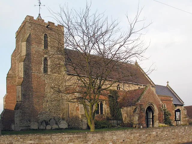
Church of St Martin
Historic churches · 3.6 km

Witcham
Villages · 3.7 km

Witcham Village Sign
Public art & sculpture · 3.7 km

RAF Mepal Memorial
Memorials & monuments · 4.3 km
Nearby
📷 5Vineyards · East of England
Wardy Hill
Wardy Hill — a UK vineyard in england london, producing English or Welsh wine from cool-climate grape varieties.
📷 5Public art & sculpture · East of England
Mepal Village Sign
Mepal Village Sign — a public art in East of England, United Kingdom.
📷 5Natural landmarks · East of England
Witcham Equestrian Centre
Witcham Equestrian Centre — a place in East of England, United Kingdom.
📷 5Memorials & monuments · East of England
Mepal War Memorial
Mepal War Memorial — Grade II listed building-listed memorial in england-london, United Kingdom.
📷 5Public art & sculpture · East of England
Coveney Village Sign
Coveney Village Sign — a public art in East of England, United Kingdom.
📷 5Historic churches · East of England
Church of St Peter-ad-Vincula
Church of St Peter-ad-Vincula — Grade I listed church in Coveney, East Cambridgeshire, England, UK.
Where to eat & stay near Ouse Washes (Hundred Foot Washes)
Places to stay
 📷 5
📷 5Hotels · East of England
The Cross Keys Inn
The Cross Keys Inn — a hotel in england london.
 📷 5
📷 5Campsites · East of England
Fen View Lakes
Fen View Lakes — a campsite in england london.
 📷 5
📷 5 📷 5
📷 5 📷 7
📷 7 📷 5
📷 5Hostels · East of England
Bishop Woodford Retreat House
Bishop Woodford Retreat House — a hostel in england london.
Places to eat & drink
 📷 7
📷 7Restaurants · East of England
The Old Fire Engine House
The Old Fire Engine House — a restaurant in england london.
 📷 7
📷 7Historic pubs · East of England
Royal Standard Public House
Royal Standard Public House in England East, United Kingdom.
 📷 7
📷 7Historic pubs · East of England
Cutter Public House
Cutter Public House in England East, United Kingdom.
 📷 5
📷 5 📷 5
📷 5 📷 5
📷 5Historic pubs · East of England
Chequers Public House
Chequers Public House in England East, United Kingdom.
More forests in this region
 📷 5
📷 5Forests & woodlands · East of England
Adams Road Bird Sanctuary
Adams Road Bird Sanctuary is a forest or woodland in the United Kingdom.
 📷 5
📷 5Forests & woodlands · East of England
Arthur's Meadow NR
Arthur's Meadow NR is a forest or woodland in the United Kingdom.
 📷 5
📷 5Forests & woodlands · East of England
Ashwell Quarry & Quarry Springs
Ashwell Quarry & Quarry Springs is a forest or woodland in the United Kingdom.
 📷 5
📷 5Forests & woodlands · East of England
Ashwell Springs
Ashwell Springs is a forest or woodland in the United Kingdom.
Frequently asked questions
- Where is Ouse Washes (Hundred Foot Washes)?
- Ouse Washes (Hundred Foot Washes) is in Cambridgeshire, East of England, United Kingdom (postcode CB6 2FJ), in the parish of Coveney.
- What is Ouse Washes (Hundred Foot Washes)?
- Ouse Washes (Hundred Foot Washes) is a forest or woodland in the United Kingdom.
- How do I get to Ouse Washes (Hundred Foot Washes)?
- The nearest railway station is Manea, about 7.8 km away. The nearest town is Wentworth. Drivers can use postcode CB6 2FJ.
- Is Ouse Washes (Hundred Foot Washes) a protected site?
- Yes — Ouse Washes (Hundred Foot Washes) is part of the Ouse Washes SSSI Site of Special Scientific Interest and the Ouse Washes Ramsar wetland.
- Is Ouse Washes (Hundred Foot Washes) free to visit?
- Yes, Ouse Washes (Hundred Foot Washes) is free to enter.
- How do I get to Ouse Washes (Hundred Foot Washes)?
- The nearest railway station is Manea, about 7.8 km away. Drivers can navigate to postcode CB6 2FJ.