
Historic houses · Scottish Lowlands
Oatfield House
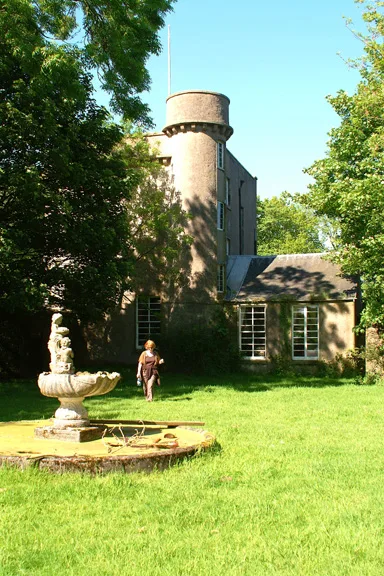
Oatfield House — house in Argyll and Bute, Scotland, UK.

Wikimedia Commons contributors — see linked file page for photographer and licence licence

Plan your visit
- Typical visit
- 1 h–2 h
- Family-friendly
- Limited wheelchair access
About
Oatfield House is a historic house in the United Kingdom — typically a country seat, manor, or town house with notable architecture or history. Heritage designation: category B listed building. Wikidata describes it as: "house in Argyll and Bute, Scotland, UK". Coordinates: 55.4014°, -5.6641°.
Photo gallery
Place summary
Oatfield House is a historic house located in the Scottish Lowlands, postcode PA28. It is designated as a category B listed building, highlighting its architectural and historical significance.
AI-generated from the structured facts on this page (operator, designation, listing, era). Not a substitute for visiting.
- Coordinates
- 55.4014, -5.6641
- District
- Argyll and Bute
- Postcode
- PA28 6PL
- Parliamentary constituency
- Argyll, Bute and South Lochaber
Sources
- wikidata: Q17772308 (CC0)
- commons: Oatfield House BandB - geograph.org.uk - 762881.jpg (CC BY-SA 4.0)
Other places nearby

Bealloch Fort
Archaeological sites · 0.5 km
Kilchrist Castle
Castles · 1.1 km

Kilchrist, dun site
Archaeological sites · 1.7 km

Tirfergus Hill
Mountains & hills · 1.9 km

Cullan Doon, hill fort
Hill forts · 2.1 km
Cullen Doon, dun site
Archaeological sites · 2.1 km

Cnoc Sturraig
Mountains & hills · 2.1 km

Drumlemble
Villages · 2.5 km

Killellan, dun site
Archaeological sites · 3.0 km

Kilkivan
Windmills · 3.1 km

Black Hill
Mountains & hills · 3.5 km

Kilkivan, Old Parish Church and graveyard
Historic churches · 3.6 km
Nearby
📷 3Archaeological sites · Scottish Lowlands
Bealloch Fort
Bealloch Fort — a archaeological in northern-ireland, United Kingdom.
📷 3Castles · Scottish Lowlands
Kilchrist Castle
Kilchrist Castle — castle in Argyll and Bute, Scotland, UK.
📷 5Archaeological sites · Scottish Lowlands
Kilchrist, dun site
Kilchrist, dun site — a archaeological in northern-ireland, United Kingdom.
📷 5Mountains & hills · Scottish Lowlands
Tirfergus Hill
Tirfergus Hill — mountain in northern ireland. Elevation: 260 m.
📷 3Hill forts · Scottish Lowlands
Cullan Doon, hill fort
Cullan Doon, hill fort — a hill fort in northern-ireland, United Kingdom.
📷 3Archaeological sites · Scottish Lowlands
Cullen Doon, dun site
Cullen Doon, dun site — a archaeological in northern-ireland, United Kingdom.
Where to eat & stay near Oatfield House
Places to stay
Caravan parks · Scottish Lowlands
Machrihanish Holiday Park
Machrihanish Holiday Park — a caravan park in scotland lowlands.
 📷 5
📷 5 📷 5
📷 5Hotels · Scottish Lowlands
The Royal Hotel
The Royal Hotel — a hotel in scotland lowlands.
 📷 5
📷 5Caravan parks · Scottish Lowlands
Peninver Sands Holiday Park
Peninver Sands Holiday Park — a caravan park in scotland lowlands.
📷 5Caravan parks · Scottish Lowlands
Peninver Sands Holiday Park
Peninver Sands Holiday Park — a caravan park in scotland lowlands.
 📷 5
📷 5Caravan parks · Scottish Lowlands
Killegruer Caravan and Campsite
Killegruer Caravan and Campsite — a caravan park in scotland highlands.
Places to eat & drink
 📷 5
📷 5Historic pubs · Scottish Lowlands
40 Main Street, Campbeltown
40 Main Street, Campbeltown in Northern Ireland, United Kingdom.
 📷 5
📷 5Cafés · Scottish Lowlands
Glenbarr Abbey - Clan Macalister Museum & Tea Room
Glenbarr Abbey - Clan Macalister Museum & Tea Room — a café in scotland highlands.
More historic houses in this region
 📷 4
📷 4Historic houses · Scottish Lowlands
Chesters estate
Chesters estate in England North East, United Kingdom.
 📷 4
📷 4 📷 3
📷 3 📷 3
📷 3Historic houses · Scottish Lowlands
Barnhills Tower
Barnhills Tower in England North East, United Kingdom.
Frequently asked questions
- Where is Oatfield House?
- Oatfield House is in the Scottish Lowlands, United Kingdom (postcode PA28 6PL).
- What is Oatfield House?
- Oatfield House — house in Argyll and Bute, Scotland, UK.
- How do I get to Oatfield House?
- Drivers can use postcode PA28 6PL.
- Is Oatfield House a listed building?
- Oatfield House is officially recognised as category B listed building listed.
- How do I get to Oatfield House?
- Drivers can navigate to postcode PA28 6PL. It sits within the Argyll, Bute and South Lochaber parliamentary constituency.