
Mountains & hills · Scottish Highlands
North West Sutherland National Scenic Area
North West Sutherland National Scenic Area in Scotland Islands, United Kingdom.

Chris Wimbush — CC BY-SA 2.0 via Wikimedia Commons licence

Plan your visit
- Typical visit
- 3 h–8 h
- Best time of year
- Late spring – early autumn (May–Oct)
- Free entry
- Dog-friendly
About
North West Sutherland National Scenic Area is a place of interest in Scotland Islands, United Kingdom — drawn from open-data sources for visitor reference. See the linked Wikipedia article for the full description.
Photo gallery
From the Wikipedia article
North West Sutherland is a national scenic area (NSA) covering the mountains and coastal scenery of the northwestern part of the county of Sutherland in the Scottish Highlands. The designated area covers the mountains of Foinaven, Arkle and Ben Stack as well as the coastal scenery surrounding Loch Laxford and Handa Island. It is one of 40 such areas in Scotland, which are defined so as to identify areas of exceptional scenery and to ensure its protection by restricting certain forms of development. The North West Sutherland NSA covers 26,565 ha in total, consisting of 23,415 ha of land with a further 3,151 ha being marine (i.e. below low tide). National scenic areas are primarily designated due to the scenic qualities of an area, however NSAs may well have other special qualities, for example related to culture, history, archaeology, geology or wildlife. Areas with such qualities may be protected via other national and international designations that overlap with the NSA designation. North West Sutherland includes several Natura 2000 sites within the designated area of the NSA. In Gaelic the area is known as Ceathramh Garb, meaning the "Rough Quarter".
Excerpt from Wikipedia under CC BY-SA 4.0. See the source article linked in Sources below.
- Coordinates
- 58.3703, -4.9048
- Address
- Sutherland, Highland, Scotland
- Established
- 1981
Sources
- wikidata: Q54869838 (CC0)
- wikipedia: North West Sutherland National Scenic Area (CC BY-SA 4.0)
Other places nearby
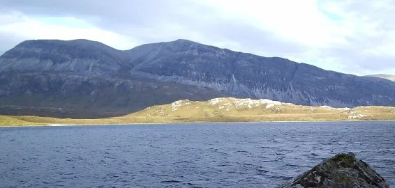
Arkle
Natural landmarks · 0.0 km
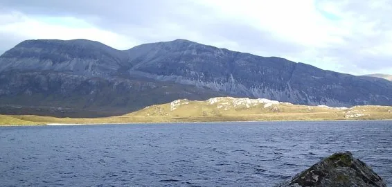
Arkle
Mountains & hills · 0.1 km

Arkle South Top
Mountains & hills · 1.1 km

Creag Riabhaich Airigh a' Bhaird
Mountains & hills · 2.1 km

Loch a’ Gharbh-bhaid Mòr
Lakes · 3.0 km

Rubh Aird a' Mhadaidh
Mountains & hills · 3.4 km

Cadha na Beucaich
Mountains & hills · 3.5 km

Stob Cadha na Beucaich
Mountains & hills · 3.5 km

Cnoc an Alltain Riabhaich
Mountains & hills · 3.6 km

A' Chèir Ghorm
Mountains & hills · 3.7 km

Cnoc Grosvenor
Mountains & hills · 3.7 km

Eddrachillis
Mountains & hills · 3.7 km
Nearby
📷 3Natural landmarks · Scottish Highlands
Arkle
Arkle — 787m high mountain in Sutherland, Highland, Scotland, UK.
📷 3📷 3Mountains & hills · Scottish Highlands
Arkle South Top
Arkle South Top — a mountain in scotland-highlands, United Kingdom.
📷 5Mountains & hills · Scottish Highlands
Creag Riabhaich Airigh a' Bhaird
Creag Riabhaich Airigh a' Bhaird — a hill or mountain in scotland highlands.
📷 5Lakes · Scottish Highlands
Loch a’ Gharbh-bhaid Mòr
Loch a’ Gharbh-bhaid Mòr — a lake in scotland highlands.
📷 5Mountains & hills · Scottish Highlands
Rubh Aird a' Mhadaidh
Rubh Aird a' Mhadaidh — a hill or mountain in scotland highlands.
Where to eat & stay near North West Sutherland National Scenic Area
Places to stay
 📷 5
📷 5 📷 5
📷 5Campsites · Scottish Highlands
Scourie Caravan and Campsite
Scourie Caravan and Campsite — a campsite in scotland highlands.
 📷 5
📷 5Caravan parks · Scottish Highlands
Choraidh Croft
Choraidh Croft — a caravan park in scotland highlands.
 📷 5
📷 5Caravan parks · Scottish Islands
Balnakeil Motorhome Stopover
Balnakeil Motorhome Stopover — a caravan park in scotland islands.
 📷 5
📷 5Hostels · Scottish Islands
Lazy Crofter Bunkhouse/Hostel
Lazy Crofter Bunkhouse/Hostel — a hostel in scotland islands.
📷 5More mountains in this region
 📷 3
📷 3Mountains & hills · Scottish Highlands
A' Bhuidheanach Bheag
A' Bhuidheanach Bheag — Named summit at 936 m.
 📷 3
📷 3Mountains & hills · Scottish Highlands
A' Chailleach
A' Chailleach — Named summit at 997 m.
 📷 3
📷 3Mountains & hills · Scottish Highlands
A' Chailleach
A' Chailleach — Named summit at 930 m.
 📷 3
📷 3Frequently asked questions
- Where is North West Sutherland National Scenic Area?
- North West Sutherland National Scenic Area is in the Scottish Highlands, United Kingdom.
- What is North West Sutherland National Scenic Area?
- North West Sutherland National Scenic Area in Scotland Islands, United Kingdom.
- How do I get to North West Sutherland National Scenic Area?
- Its coordinates are 58.3703°, -4.9048°.
- When was North West Sutherland National Scenic Area built?
- Built or established in 1981.
- Who owns North West Sutherland National Scenic Area?
- North West Sutherland National Scenic Area is owned by NatureScot.
- Is North West Sutherland National Scenic Area free to visit?
- Yes, North West Sutherland National Scenic Area is free to enter.