
Historic churches · East Midlands
North Thoresby
In or near Tetney.
North Thoresby is a village and civil parish in the East Lindsey district of Lincolnshire, England. It is situated between Louth and Grimsby, approximately 7.5 miles (12 km) from each. and has a villa

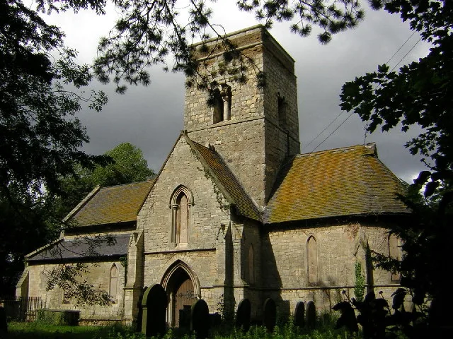
Ian S — CC BY-SA 2.0 via Wikimedia Commons licence

Plan your visit
- Typical visit
- 30 min–1 h
- Nearest railway station
- North Thoresby · 0.9 km
- Free entry
Getting there & planning your visit
To visit North Thoresby church, the nearest railway station is North Thoresby, located 0.9 km away. The postcode for navigation is DN36 5QP, and entry to the church is free.
About
North Thoresby is a village and civil parish in the East Lindsey district of Lincolnshire, England. It is situated between Louth and Grimsby, approximately 7.5 miles (12 km) from each. and has a village population of 1,068 (2011) Some 50.5% of the population is older than 60 years. The area is chiefly agricultural, but the majority of employed residents work in Grimsby and Cleethorpes, or in the industries situated on the Humber bank. The name North Thoresby is composed of the given name Thor and the suffix 'by', as with other villages in the area – indicating the influence of the Vikings. South Thoresby, also in Lincolnshire, is located to the south of Louth. Thoresby Hall is not in this area, but is located in Nottinghamshire some 50 miles (80 km) to the west.
Photo gallery
Protected designations
- Site of Special Scientific Interest: Humber Estuary - 2000480 SSSI
- Area of Outstanding Natural Beauty: Lincolnshire Wolds
- Ramsar wetland: Humber Estuary
Designations sourced from Natural England open data under OGL v3.
From the Wikipedia article
North Thoresby is a village and civil parish in the East Lindsey district of Lincolnshire, England. It is situated between Louth and Grimsby, approximately 7.5 miles (12 km) from each. and has a village population of 1,068 (2011) Some 50.5% of the population is older than 60 years. The area is chiefly agricultural, but the majority of employed residents work in Grimsby and Cleethorpes, or in the industries situated on the Humber bank. The name North Thoresby is composed of the given name Thor and the suffix 'by', as with other villages in the area – indicating the influence of the Vikings. South Thoresby, also in Lincolnshire, is located to the south of Louth. Thoresby Hall is not in this area, but is located in Nottinghamshire some 50 miles (80 km) to the west.
Excerpt from Wikipedia under CC BY-SA 4.0. See the source article linked in Sources below.
Background
History
Researchers believe they found archeological evidence, just outside the village, that grapes were grown in the area by the Romans during their occupation. This claim has been contested. The Village lies on a Roman road from Cadeby to North Coates, believed to have been a route of salt transportation from the coast to Lincoln. occupies a site where Christian worship has continued for more than 1,000 years. Like most churches of its age it has seen many alterations from an original simple room to a 15th-century edifice with north and south aisles. The south aisle was demolished in Elizabethan times but remains of it survive inside the church. The church includes part of a Saxon grave cover,…
Sourced from Wikipedia under CC BY-SA 4.0.
- Coordinates
- 53.4667, -0.0544
- County
- Lincolnshire
- District
- East Lindsey
- Parish
- North Thoresby
- Postcode
- DN36 5QP
- Parliamentary constituency
- Louth and Horncastle
- Nearest railway station
- North Thoresby — 0.9 km
Sources
- wikipedia: North Thoresby (CC BY-SA 4.0)
Other places nearby

St Helen's Church, North Thoresby
Historic churches · 0.4 km

Grainsby
Villages · 1.4 km

Grainsby
Historic churches · 1.8 km

Waithe
Historic churches · 2.4 km

Waithe
Vineyards · 2.4 km
St Martin's Church
Historic churches · 2.4 km

Lincolnshire Wolds Railway
Museums · 2.9 km

Ludborough
Museums · 2.9 km

Church of Saint Margaret, Hawerby cum Beesby
Historic churches · 3.3 km

Tetney
Towns & cities · 3.4 km

Fulstow
Historic churches · 3.5 km

Wyham cum Cadeby
Historic churches · 3.6 km
Nearby
📷 5Historic churches · East Midlands
St Helen's Church, North Thoresby
St Helen's Church is the Anglican parish church in the village of North Thoresby in Lincolnshire, England. Built of squared limestone rubble, chalk and limestone coursed rubble, the church is a Grade
📷 5📷 5Historic churches · East Midlands
Grainsby
Grainsby is a hamlet and civil parish in the East Lindsey district of Lincolnshire, England. It is situated 5 miles (8 km) south from Grimsby, and just to the west from the A16 road. The nearest villa
📷 5Historic churches · East Midlands
Waithe
Waithe — a church in england-east-midlands, United Kingdom.
📷 5Vineyards · East Midlands
Waithe
Waithe — a UK vineyard in england east midlands, producing English or Welsh wine from cool-climate grape varieties.
📷 5Historic churches · East Midlands
St Martin's Church
St Martin's Church — church in Waithe, Lincolnshire, England, UK.
Where to eat & stay near North Thoresby
Places to stay
 📷 5
📷 5Caravan parks · East Midlands
Little End Corner Caravan Park
Little End Corner Caravan Park — a caravan park in england east midlands.
 📷 5
📷 5Caravan parks · East Midlands
Windy Ridge Caravan Site & Fishing Lakes
Windy Ridge Caravan Site & Fishing Lakes — a caravan park in england east midlands.
 📷 3
📷 3 📷 5
📷 5Campsites · East Midlands
Cherry Garth Scout Campsite
Cherry Garth Scout Campsite — a campsite in england yorkshire.
 📷 5
📷 5Campsites · East Midlands
Epperstone Residential Caravan Park
Epperstone Residential Caravan Park — a campsite in england yorkshire.
 📷 5
📷 5Caravan parks · East Midlands
Cleethorpes Beach Park
Cleethorpes Beach Park — a caravan park in england yorkshire.
Places to eat & drink
 📷 5
📷 5Historic pubs · East Midlands
The Signal Box Inn
The Signal Box Inn in England East Midlands, United Kingdom.
 📷 3
📷 3Historic pubs · Yorkshire & the Humber
Tivoli Tavern
Tivoli Tavern — Historic pub — listed building or notable heritage status.
 📷 5
📷 5 📷 5
📷 5Historic pubs · East Midlands
Massingberd Arms
Massingberd Arms in England East Midlands, United Kingdom.
More places in this region
 📷 5
📷 5Historic churches · East Midlands
All Saints' Church, Stamford
All Saints' Church, Stamford — church in Stamford, Lincolnshire, England, UK.
 📷 5
📷 5Historic churches · East Midlands
Church of All Saints
Church of All Saints — church in Little Casterton, Rutland, United Kingdom.
 📷 5
📷 5Historic churches · East Midlands
Church of All Saints
Church of All Saints — church in Fenland, UK.
 📷 5
📷 5Historic churches · East Midlands
Church of St Leonard
Church of St Leonard — church in Fenland, UK.
Frequently asked questions
- Where is North Thoresby?
- North Thoresby is in Lincolnshire, the East Midlands, United Kingdom (postcode DN36 5QP), in the parish of North Thoresby.
- What is North Thoresby?
- North Thoresby is a village and civil parish in the East Lindsey district of Lincolnshire, England. It is situated between Louth and Grimsby, approximately 7.5 miles (12 km) from each. and has a villa
- How do I get to North Thoresby?
- The nearest railway station is North Thoresby, about 0.9 km away. Drivers can use postcode DN36 5QP.
- Is North Thoresby a protected site?
- Yes — North Thoresby is part of the Humber Estuary - 2000480 SSSI Site of Special Scientific Interest and the Lincolnshire Wolds National Landscape (AONB).
- Is North Thoresby free to visit?
- Yes, North Thoresby is free to enter.
- How do I get to North Thoresby?
- The nearest railway station is North Thoresby, about 0.9 km away. Drivers can navigate to postcode DN36 5QP.