
Historic bridges · East Midlands
Nornay South Bridge
In or near Ranskill.
Nornay South Bridge — Grade II listed building-listed bridge in england-east-midlands, United Kingdom.

SMJ — CC BY-SA 2.0 via Wikimedia Commons licence

Plan your visit
- Typical visit
- 15 min–30 min
- Nearest railway station
- Worksop · 8.8 km
- Free entry
- Dog-friendly
Getting there & planning your visit
To visit Nornay South Bridge in Bassetlaw, Nottinghamshire, the nearest railway station is Worksop, located 8.8 km away. Entry to the bridge is free.
About
Nornay South Bridge is a Grade II listed building-listed bridge in england-east-midlands, United Kingdom, registered on the National Heritage List for England (NHLE entry 1279728). Listed status protects buildings and structures of special architectural or historic interest. See the linked Wikipedia article for further details.
Photo gallery
Heritage listing
Details SK 68 NW BLYTH BAWTRY ROAD 2/27 Nornay South Bridge G.V. II Bridge. Late C18. Ashlar. 2 small depressed arches with band at road level. The east side has a single cutwater, the west, with rusticated arches, has 3 rusticated cutwaters. The central one having 2 iron brackets, the northern one a single similar bracket with a wooden beam running between the two. The ashlar parapets terminate in single round piers. Listing NGR: SK6244687609 Legacy The contents of this record have been generated from a legacy data system. Legacy System number: 241055 Legacy System: LBS
From the Historic England List Entry under OGL v3.
Place summary
Nornay South Bridge is a Grade II listed bridge located in the East Midlands. Its designation reflects its architectural significance and historical value within the region.
AI-generated from the structured facts on this page (operator, designation, listing, era). Not a substitute for visiting.
- Coordinates
- 53.3817, -1.0627
- County
- Nottinghamshire
- District
- Bassetlaw
- Parish
- Blyth
- Postcode
- S81 8HG
- Parliamentary constituency
- Bassetlaw
- Nearest railway station
- Worksop — 8.8 km
Sources
- wikidata: Q26568924 (CC0)
Other places nearby
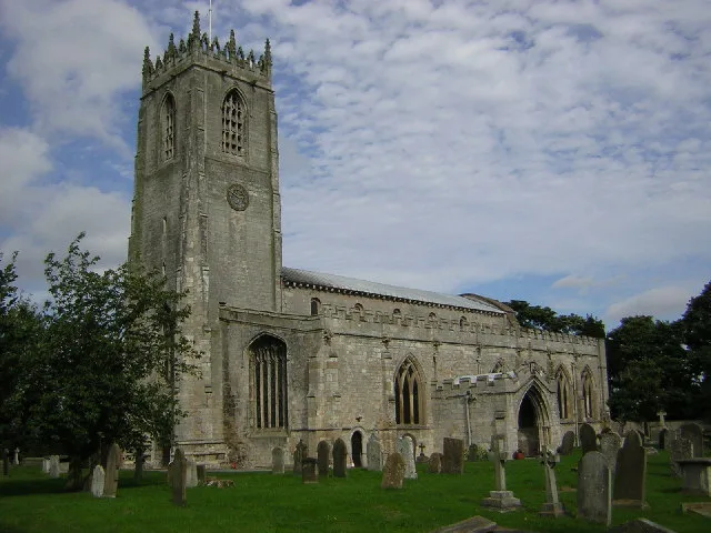
St. Mary and St. Martin’s Church, Blyth
Historic churches · 0.3 km

The Red Hart Hotel
Historic pubs · 0.5 km

Blyth New Bridge
Historic bridges · 0.8 km

Blyth And Hodsock War Memorial
Memorials & monuments · 1.0 km

The Theatre
Open-air theatres · 2.1 km

Serlby Hall
Historic houses · 2.2 km

Bridge 45 Metres South Of Reeves Cottage, Serlby Park
Historic bridges · 2.2 km
Bridge To Serlby Hall
Historic bridges · 2.3 km

Arch
Memorials & monuments · 2.4 km
Bridge over River Ryton, west of Laundry Cottage, Serlby Park
Historic bridges · 2.5 km

Hodsock Priory
Abbeys & priories · 2.6 km

Harworth Colliery
Mountains & hills · 2.9 km
Nearby
📷 5Historic churches · East Midlands
St. Mary and St. Martin’s Church, Blyth
St. Mary and St. Martin’s Church, Blyth — church in Bassetlaw, UK.
📷 5Historic pubs · East Midlands
The Red Hart Hotel
The Red Hart Hotel in England Yorkshire, United Kingdom.
📷 3Historic bridges · East Midlands
Blyth New Bridge
Blyth New Bridge — scheduled monument-listed bridge in england-east-midlands, United Kingdom.
📷 3Memorials & monuments · East Midlands
Blyth And Hodsock War Memorial
Blyth And Hodsock War Memorial — Grade II listed building-listed memorial in england-east-midlands, United Kingdom.
📷 5Open-air theatres · East Midlands
The Theatre
The Theatre — a open-air theatre in england east midlands.
📷 3Historic houses · East Midlands
Serlby Hall
Serlby Hall — Grade I listed building in Bassetlaw, United Kingdom.
Where to eat & stay near Nornay South Bridge
Places to stay
 📷 5
📷 5Campsites · East Midlands
Pilgrim Fathers Camping Site
Pilgrim Fathers Camping Site — a campsite in england east midlands.
 📷 5
📷 5Caravan parks · East Midlands
Plumtree Caravan Park
Plumtree Caravan Park — a caravan park in england east midlands.
 📷 5
📷 5Caravan parks · East Midlands
Marshall's Caravan Park
Marshall's Caravan Park — a caravan park in england east midlands.
 📷 5
📷 5Caravan parks · East Midlands
Clumber Park Caravan and Motorhome Club
Clumber Park Caravan and Motorhome Club — a caravan park in england east midlands.
 📷 5
📷 5 📷 5
📷 5Campsites · East Midlands
Clumber Park Lodges
Clumber Park Lodges — a campsite in england east midlands.
Places to eat & drink
📷 5Historic pubs · East Midlands
The Red Hart Hotel
The Red Hart Hotel in England Yorkshire, United Kingdom.
 📷 5
📷 5 📷 5
📷 5Historic pubs · East Midlands
Newcastle Arms Public House
Newcastle Arms Public House in England Yorkshire, United Kingdom.
 📷 5
📷 5 📷 7
📷 7Historic pubs · East Midlands
Black Boy Public House
Black Boy Public House in England Yorkshire, United Kingdom.
 📷 5
📷 5Historic pubs · East Midlands
New Inn Public House
New Inn Public House in England Yorkshire, United Kingdom.
More bridges in this region
 📷 5
📷 5Historic bridges · East Midlands
Mill Race Bridge To Market Deeping Mill
Mill Race Bridge To Market Deeping Mill — Grade II listed building-listed bridge in england-london, United Kingdom.
 📷 5
📷 5Historic bridges · East Midlands
Bridge Over West Glen River
Bridge Over West Glen River — Grade II listed building-listed bridge in england-london, United Kingdom.
 📷 5
📷 5Historic bridges · East Midlands
Bridge And Sluices
Bridge And Sluices — Grade II listed building-listed bridge in england-london, United Kingdom.
 📷 5
📷 5Historic bridges · East Midlands
Bridge Over River Gwash
Bridge Over River Gwash — Grade II listed building-listed bridge in england-london, United Kingdom.
Frequently asked questions
- Where is Nornay South Bridge?
- Nornay South Bridge is in Nottinghamshire, the East Midlands, United Kingdom (postcode S81 8HG), in the parish of Blyth.
- What is Nornay South Bridge?
- Nornay South Bridge — Grade II listed building-listed bridge in england-east-midlands, United Kingdom.
- How do I get to Nornay South Bridge?
- The nearest railway station is Worksop, about 8.8 km away. Drivers can use postcode S81 8HG.
- Is Nornay South Bridge a listed building?
- Nornay South Bridge is officially recognised as Grade II listed building listed.
- Is Nornay South Bridge free to visit?
- Yes, Nornay South Bridge is free to enter.
- How do I get to Nornay South Bridge?
- Drivers can navigate to postcode S81 8HG. It sits within the Bassetlaw parliamentary constituency.