
Historic churches · East Midlands
Normanby by Spital
In or near Hackthorn.
Normanby by Spital is a village and civil parish in the West Lindsey district of Lincolnshire, England. According to the 2001 census it had a population of 318, increasing to 412 at the 2011 census.

Jonathan Thacker — CC BY-SA 2.0 via Wikimedia Commons licence

Plan your visit
- Typical visit
- 30 min–1 h
- Free entry
Getting there & planning your visit
To visit Normanby by Spital, you can use the postcode LN8 2EA for sat-nav directions. Entry to the church is free.
About
Normanby by Spital is a village and civil parish in the West Lindsey district of Lincolnshire, England. According to the 2001 census it had a population of 318, increasing to 412 at the 2011 census. It is approximately 10 miles (16 km) north from Lincoln, and just off the A15. The village is part of the Owmby Group of parishes. The name Normanby is from the Old English and Old Scandinavian Northman+by, or "Northman village". In the 1086 Domesday Book, the village is given as Normanebi. Normanby by Spital also has a neighbouring village called Owmby-by-Spital. St. Peter's Church dates from the 12th century and is a Grade I listed building. It is redundant and maintained by the Churches Conservation Trust. The church is dedicated to St. Peter and St. Paul. It was extensively renovated in 1890 and it currently seats 100 people. There was a Methodist chapel but now it has been converted into a habitable accommodation. The village facilities include a primary school, a post office, a store, The Bottle and Glass public house, and a school hall. The school hall holds activities such as a youth club and an art club. Normanby by Spital primary school received a 2006 Ofsted inspection rating of Grade 1 (outstanding). A following 2010 inspection rated the school as Grade 2 (good). During the Second World War, a wireless station was in operation along Normanby Cliff Road which was connected to RAF Scampton and was used to transmit messages to Bomber Squadrons over Germany or other en
Photo gallery
Protected designations
- Ramsar wetland: Humber Estuary
Designations sourced from Natural England open data under OGL v3.
From the Wikipedia article
Normanby by Spital is a village and civil parish in the West Lindsey district of Lincolnshire, England. According to the 2001 census it had a population of 318, increasing to 412 at the 2011 census. It is approximately 10 miles (16 km) north from Lincoln, and just off the A15. The village is part of the Owmby Group of parishes. The name Normanby is from the Old English and Old Scandinavian Northman+by, or "Northman village". In the 1086 Domesday Book, the village is given as Normanebi. Normanby by Spital also has a neighbouring village called Owmby-by-Spital.
St. Peter's Church dates from the 12th century and is a Grade I listed building. It is redundant and maintained by the Churches Conservation Trust. The church is dedicated to St. Peter and St. Paul. It was extensively renovated in 1890 and it currently seats 100 people. There was a Methodist chapel but now it has been converted into a habitable accommodation. The village facilities include a primary school, a post office, a store, The Bottle and Glass public house, and a school hall. The school hall holds activities such as a youth club and an art club. Normanby by Spital primary school received a 2006 Ofsted inspection rating of Grade 1 (outstanding). A following 2010 inspection rated the school as Grade 2 (good). During the Second World War, a wireless station was in operation along Normanby Cliff Road which was connected to RAF Scampton and was used to transmit messages to Bomber Squadrons over Germany or other enemy territory. Each Bomber Command Group had a similar site and they could be found all over the east of the country. The R/T operators were based at RAF Bawtry, Doncaster. This role continued throughout the "Cold War" period when transmissions were made to the 24/7 airborne V-Bomber squadrons. In later years this role diminished and the station finally closed; the buildings have now been demolished although the site is still fenced off. The Bottle and Glass public house was open for duration of
Excerpt from Wikipedia under CC BY-SA 4.0. See the source article linked in Sources below.
- Coordinates
- 53.3806, -0.4967
- County
- Lincolnshire
- District
- West Lindsey
- Parish
- Normanby by Spital
- Postcode
- LN8 2EA
- Parliamentary constituency
- Gainsborough
Sources
- wikipedia: Normanby by Spital (CC BY-SA 4.0)
Other places nearby

Normanby-by-Spital
Villages · 0.0 km
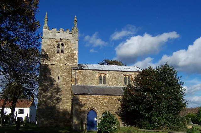
St Peter's Church, Normanby by Spital
Historic churches · 0.0 km

Caenby
Historic churches · 0.5 km

Owmby-by-Spital
Villages · 0.7 km

Saxby
Villages · 1.8 km

Church of St Helen, Saxby
Historic churches · 2.0 km

Glentham
Villages · 2.1 km

Glentham
Historic churches · 2.7 km

Lincolnshire Lanes
Campsites · 2.8 km

Spridlington
Historic churches · 3.7 km

Spital in the Street
Villages · 3.9 km

Toft next Newton
Villages · 4.2 km
Nearby
📷 5📷 3Historic churches · East Midlands
St Peter's Church, Normanby by Spital
St Peter's Church, Normanby by Spital — church in West Lindsey, UK.
📷 5Historic churches · East Midlands
Caenby
Caenby is a hamlet and civil parish in the West Lindsey district of Lincolnshire, England. It is situated 10 miles (16 km) north of the city and county town of Lincoln. The population is included in t
📷 5📷 5📷 3Historic churches · East Midlands
Church of St Helen, Saxby
Church of St Helen, Saxby — Grade I listed building-listed church in england-east-midlands, United Kingdom.
Where to eat & stay near Normanby by Spital
Places to stay
📷 5Campsites · East Midlands
Lincolnshire Lanes
Lincolnshire Lanes — a campsite in england east midlands.
 📷 5
📷 5Campsites · East Midlands
Welton Manor Camp Site
Welton Manor Camp Site — a campsite in england east midlands.
 📷 5
📷 5Caravan parks · East Midlands
Stonecliff Park
Stonecliff Park — a caravan park in england east midlands.
 📷 5
📷 5Campsites · East Midlands
Brandy Wharf Leisure Park
Brandy Wharf Leisure Park — a campsite in england east midlands.
 📷 5
📷 5Campsites · East Midlands
Walesby Woodlands
Walesby Woodlands — a campsite in england east midlands.
📷 5Caravan parks · East Midlands
Walesby Woodlands Caravan Park
Walesby Woodlands Caravan Park — a caravan park in england east midlands.
Places to eat & drink
 📷 7
📷 7 📷 5
📷 5 📷 5
📷 5Restaurants · East Midlands
Cafe Zoot
Cafe Zoot — a restaurant in england east midlands.
 📷 5
📷 5Historic pubs · East Midlands
268, High Street
268, High Street in England East Midlands, United Kingdom.
 📷 5
📷 5Cafés · East Midlands
Madame Waffle
Madame Waffle — a café in england east midlands.
 📷 5
📷 5Cafés · East Midlands
Little Lincoln Cafe
Little Lincoln Cafe — a café in england east midlands.
More places in this region
 📷 5
📷 5Historic churches · East Midlands
All Saints' Church, Stamford
All Saints' Church, Stamford — church in Stamford, Lincolnshire, England, UK.
 📷 5
📷 5Historic churches · East Midlands
Church of All Saints
Church of All Saints — church in Little Casterton, Rutland, United Kingdom.
 📷 5
📷 5Historic churches · East Midlands
Church of All Saints
Church of All Saints — church in Fenland, UK.
 📷 5
📷 5Historic churches · East Midlands
Church of St Leonard
Church of St Leonard — church in Fenland, UK.
Frequently asked questions
- Where is Normanby by Spital?
- Normanby by Spital is in Lincolnshire, the East Midlands, United Kingdom (postcode LN8 2EA), in the parish of Normanby by Spital.
- What is Normanby by Spital?
- Normanby by Spital is a village and civil parish in the West Lindsey district of Lincolnshire, England. According to the 2001 census it had a population of 318, increasing to 412 at the 2011 census.
- How do I get to Normanby by Spital?
- The nearest town is Hackthorn. Drivers can use postcode LN8 2EA.
- Is Normanby by Spital a protected site?
- Yes — Normanby by Spital is part of the Humber Estuary Ramsar wetland.
- Is Normanby by Spital free to visit?
- Yes, Normanby by Spital is free to enter.
- How do I get to Normanby by Spital?
- Drivers can navigate to postcode LN8 2EA. It sits within the Gainsborough parliamentary constituency.