
Mountains & hills · South East England
Noar Hill
In or near Empshott.
Noar Hill — Named summit at 210 m.

Wikimedia Commons contributors — see linked file page for photographer and licence licence

Plan your visit
- Typical visit
- 3 h–8 h
- Best time of year
- Late spring – early autumn (May–Oct)
- Nearest railway station
- Liss · 4.9 km
- Free entry
- Dog-friendly
Getting there & planning your visit
To visit Noar Hill, the nearest railway station is Liss, located 4.9 km away. The postcode for navigation is GU33 6HX, and entry is free.
About
Noar Hill is a named summit in the United Kingdom. Wikidata describes it as: "Named summit at 210 m.". Coordinates: 51.0803°, -0.9324°.
Photo gallery
Protected designations
- Site of Special Scientific Interest: Noar Hill SSSI
- Site of Special Scientific Interest: Upper Greensand Hangers: Empshott to Hawkley SSSI
Designations sourced from Natural England open data under OGL v3.
From the Wikipedia article
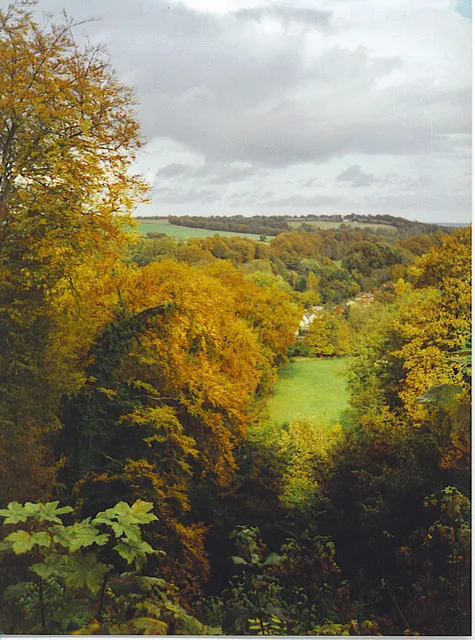
Noar Hill is a 63-hectare (160-acre) biological Site of Special Scientific Interest south of Selborne in Hampshire. It is a Nature Conservation Review site, Grade 2, and part of East Hampshire Hangers Special Area of Conservation. An area of 20 hectares (49 acres) is a nature reserve managed by the Hampshire and Isle of Wight Wildlife Trust. Noar Hill summit is approximately 214 metres above sea-level. It is one the East Hampshire Hangers, a chain of low but steep hills in the Hampshire Downs, west of the South Downs. The western and northern slopes are gentle, but the eastern and southern slopes have gradients exceeding 60%. Gilbert White, in his Natural History of Selborne, says of Noar Hill: At each end of the village [Selborne], which runs from south-east to north-west, arises a small rivulet: that at the north-west end frequently fails: but the other is a fine perennial spring little influenced by drought or wet seasons, called Well-head. This breaks out of some high grounds adjoining to Nore Hill, a noble chalk promontory, remarkable for sending forth two streams into two different seas. The one to the south becomes a branch of the Arun, running to Arundel, and so falling into the British channel: the other to the north. The western flanks and much of the summit are given over to arable fields. A smaller part of the summit, 20 hectares (about 49 acres) known as High Common, is covered with downland grasses and scrub. The northern, eastern and southern flanks are covered by deciduous woodland dominated by beech. Such beechwoods on steep hills in East Hampshire are termed "hangers". High Common is the site of mediaeval chalk-workings – chalk was dug out and spread on nearby fields as fertilizer. The excavations have left an irregular network of pits and hollows of varying size, depth, and steepness. Because the ground is so uneven, High Common remained unploughed for centuries and was only used for grazing. It retains the ancient chalk downland flora which…
Excerpt from Wikipedia under CC BY-SA 4.0. See the source article linked in Sources below.
- Coordinates
- 51.0803, -0.9324
- County
- Hampshire
- District
- East Hampshire
- Parish
- Hawkley
- Postcode
- GU33 6HX
- Parliamentary constituency
- East Hampshire
- Nearest railway station
- Liss — 4.9 km
Sources
- osm: n367374241 (ODbL)
- wikipedia: Noar Hill (CC BY-SA 4.0)
- commons: Noar Hill 01.jpg (CC BY-SA 4.0)
Other places nearby

Empshott
Towns & cities · 0.6 km

The Selborne Arms
Historic pubs · 1.9 km
Selborne Hill
Mountains & hills · 1.9 km

Selborne
Towns & cities · 2.0 km

Plestor House
Historic houses · 2.0 km

The Wakes
Historic houses · 2.1 km

Gilbert White's House
Museums · 2.1 km

Selborne War Memorial
Memorials & monuments · 2.1 km

Goleigh Hill
Mountains & hills · 2.4 km

Hawkley
Villages · 2.6 km

Newton Valence War Memorial
Memorials & monuments · 2.7 km

Greatham Manor House
Manor houses · 2.9 km
Nearby
📷 5📷 7Historic pubs · South East England
The Selborne Arms
The Selborne Arms in England South East, United Kingdom.
📷 5📷 5Towns & cities · South East England
Selborne
Selborne — village in East Hampshire, England, UK.
📷 5Historic houses · South East England
Plestor House
Plestor House — house in Selborne, Hampshire, England, UK.
📷 5Historic houses · South East England
The Wakes
The Wakes — Grade I listed building in East Hampshire, England, UK.
Where to eat & stay near Noar Hill
Places to stay
 📷 5
📷 5Caravan parks · South East England
Whitehill Park
Whitehill Park — a caravan park in england south east.
 📷 5
📷 5Hotels · South East England
Old Thorns Manor Hotel
Old Thorns Manor Hotel — a hotel in england south east.
 📷 5
📷 5 📷 7
📷 7 📷 7
📷 7Hotels · South East England
Alton House Hotel
Alton House Hotel — a hotel in england south east.
 📷 5
📷 5Places to eat & drink
📷 7Historic pubs · South East England
The Selborne Arms
The Selborne Arms in England South East, United Kingdom.
 📷 5
📷 5Historic pubs · South East England
The Harrow
The Harrow in England South East, United Kingdom.
 📷 5
📷 5 📷 7
📷 7Historic pubs · South East England
The Good Intent
The Good Intent in England South East, United Kingdom.
 📷 6
📷 6 📷 5
📷 5Historic pubs · South East England
The 'Eight Bells' Public House
The 'Eight Bells' Public House in England South East, United Kingdom.
More mountains in this region
 📷 5
📷 5 📷 5
📷 5Mountains & hills · South East England
Reigate Caves
Reigate Caves is a mountain or hill in the United Kingdom.
 📷 5
📷 5Mountains & hills · South East England
North Downs
North Downs — a hill or mountain in england london.
 📷 5
📷 5Mountains & hills · South East England
Blue Bell Hill
Blue Bell Hill — a hill or mountain in england london.
Frequently asked questions
- Where is Noar Hill?
- Noar Hill is in Hampshire, South-East England, United Kingdom (postcode GU33 6HX), in the parish of Hawkley.
- What is Noar Hill?
- Noar Hill — Named summit at 210 m.
- How do I get to Noar Hill?
- The nearest railway station is Liss, about 4.9 km away. Drivers can use postcode GU33 6HX.
- Is Noar Hill a protected site?
- Yes — Noar Hill is part of the Noar Hill SSSI Site of Special Scientific Interest and the Upper Greensand Hangers: Empshott to Hawkley SSSI Site of Special Scientific Interest.
- Is Noar Hill free to visit?
- Yes, Noar Hill is free to enter.
- How do I get to Noar Hill?
- The nearest railway station is Liss, about 4.9 km away. Drivers can navigate to postcode GU33 6HX.