Museums · East Midlands
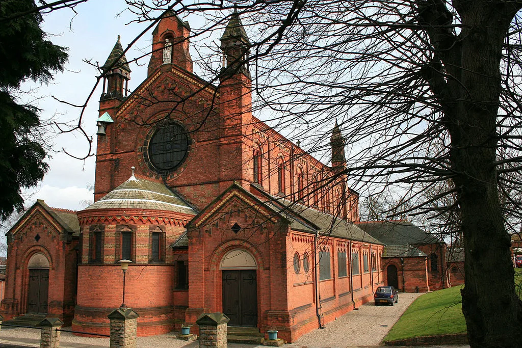
Netherfield, Nottinghamshire
In or near Burton Joyce.
Netherfield is a town in the Borough of Gedling in Nottinghamshire, England. It is situated to the east of Nottingham's city boundary and is approximately 3 miles (4.8 km) between Colwick and Carlton

JThomas — CC BY-SA 2.0 via Wikimedia Commons licence
Plan your visit
- Typical visit
- 1.5 h–3 h
- Best time of year
- Year-round
- Nearest railway station
- Carlton · 0.2 km
- Family-friendly
- Limited wheelchair access
Getting there & planning your visit
To visit the museum in Netherfield, Nottinghamshire, you can get to Carlton railway station, which is 0.2 km away. The postcode for navigation is NG4 2HG. Please note that wheelchair accessibility is limited.
About
Netherfield is a town in the Borough of Gedling in Nottinghamshire, England. It is situated to the east of Nottingham's city boundary and is approximately 3 miles (4.8 km) between Colwick and Carlton in the NG4 postcode area, and near the River Trent. The appropriate Gedling ward was called 'Netherfield and Colwick' until boundary reorganisation in 2015, when it became 'Netherfield', with 'Colwick' becoming a separate ward.. At the time of the 2011 census, the population of this ward was 7,398.
Photo gallery
From the Wikipedia article
Netherfield is a town in the Borough of Gedling in Nottinghamshire, England. It is situated to the east of Nottingham's city boundary and is approximately 3 miles (4.8 km) between Colwick and Carlton in the NG4 postcode area, and near the River Trent. The appropriate Gedling ward was called 'Netherfield and Colwick' until boundary reorganisation in 2015, when it became 'Netherfield', with 'Colwick' becoming a separate ward.. At the time of the 2011 census, the population of this ward was 7,398.
Excerpt from Wikipedia under CC BY-SA 4.0. See the source article linked in Sources below.
Background
History
Anciently, it was the Nether, or Lower Field of Carlton in the Willows within the Parish of Gedling covering some 168 acre, two roods and 19 perches. The ancient Nether Field was formed by the parochial boundaries and the effects of the eighteenth century enclosure of Gedling. Nottinghamshire’s Historic Environment Record (HER) entry [M8927] suggests that our Anglo-Saxon forebears established a cremation cemetery in what is now the Netherfield area of Carlton, close to the River Trent and just downstream from Nottingham. There are six known pots which survive and these now reside in the University of Nottingham’s Museum of Archaeology. The south-western boundary today is the…
Sourced from Wikipedia under CC BY-SA 4.0.
- Coordinates
- 52.9636, -1.0781
- County
- Nottinghamshire
- District
- Gedling
- Parish
- Gedling, unparished area
- Postcode
- NG4 2HG
- Parliamentary constituency
- Gedling
- Nearest railway station
- Carlton — 0.2 km
Sources
- wikipedia: Netherfield, Nottinghamshire (CC BY-SA 4.0)
Other places nearby

Carlton, Nottinghamshire
Museums · 0.8 km
St. Paul's Church, Carlton-in-the-Willows
Historic churches · 0.9 km

Derbyshire Extension Branch
Historic bridges · 1.0 km

Carlton Cemetery
Cemeteries · 1.1 km

Colwick
Villages · 1.1 km

Martin Brandon-Bravo O.B.E.
Memorials & monuments · 1.2 km

Borough of Gedling
Museums · 1.3 km
Derbyshire Extension Branch
Historic bridges · 1.4 km

Gedling
Villages · 1.4 km

Gedling Miners' Memorial
Memorials & monuments · 1.4 km

Church of All Hallows, Gedling
Historic churches · 1.5 km

Derbyshire Extension Branch
Historic bridges · 1.6 km
Nearby
📷 5Museums · East Midlands
Carlton, Nottinghamshire
Carlton is a town in the Borough of Gedling, Nottinghamshire, England. It is to the east of Nottingham. The population at the 2011 Census was 6,881. It was an urban district until 1974, whose wards (C
📷 3Historic churches · East Midlands
St. Paul's Church, Carlton-in-the-Willows
St. Paul's Church, Carlton-in-the-Willows — grade II listed church in Gedling, Nottinghamshire, England, UK.
📷 3Historic bridges · East Midlands
Derbyshire Extension Branch
Derbyshire Extension Branch is a historic bridge in the United Kingdom.
📷 3Cemeteries · East Midlands
Carlton Cemetery
Carlton Cemetery is a cemetery in the United Kingdom.
📷 5📷 3Memorials & monuments · East Midlands
Martin Brandon-Bravo O.B.E.
Martin Brandon-Bravo O.B.E. — a memorial in england-east-midlands, United Kingdom.
Where to eat & stay near Netherfield, Nottinghamshire
Places to stay
 📷 5
📷 5Hotels · East Midlands
Colwick Hall
Colwick Hall — a hotel in england east midlands.
 📷 5
📷 5Campsites · East Midlands
Bell Tent Village Parks
Bell Tent Village Parks — a campsite in england east midlands.
 📷 5
📷 5Campsites · East Midlands
Holme Pierrepont Country Park
Holme Pierrepont Country Park — a campsite in england east midlands.
 📷 5
📷 5Campsites · East Midlands
Canping & Caravan Club Nottingham Site
Canping & Caravan Club Nottingham Site — a campsite in england east midlands.
 📷 5
📷 5Hotels · East Midlands
Lace Market Hotel
Lace Market Hotel — a hotel in england east midlands.
 📷 5
📷 5Hostels · East Midlands
Midtown Hostel
Midtown Hostel — a hostel in england east midlands.
Places to eat & drink
 📷 5
📷 5Historic pubs · East Midlands
Manvers Arms Public House
Manvers Arms Public House in England East Midlands, United Kingdom.
 📷 7
📷 7Historic pubs · East Midlands
Bath Inn Public House
Bath Inn Public House in England East Midlands, United Kingdom.
 📷 5
📷 5Restaurants · East Midlands
Pizza Pilgrims
Pizza Pilgrims — a restaurant in england east midlands. Cuisine: pizza. Brand: Pizza Pilgrims.
 📷 3
📷 3Historic pubs · East Midlands
Pitcher & Piano
Pitcher & Piano — Historic pub — listed building or notable heritage status.
 📷 5
📷 5Historic pubs · East Midlands
22 Fletcher Gate
22 Fletcher Gate in England East Midlands, United Kingdom.
 📷 5
📷 5Cafés · East Midlands
Black Sheep Coffee
Black Sheep Coffee — a café in england east midlands. Cuisine: coffee shop. Brand: Black Sheep Coffee.
More museums in this region
 📷 5
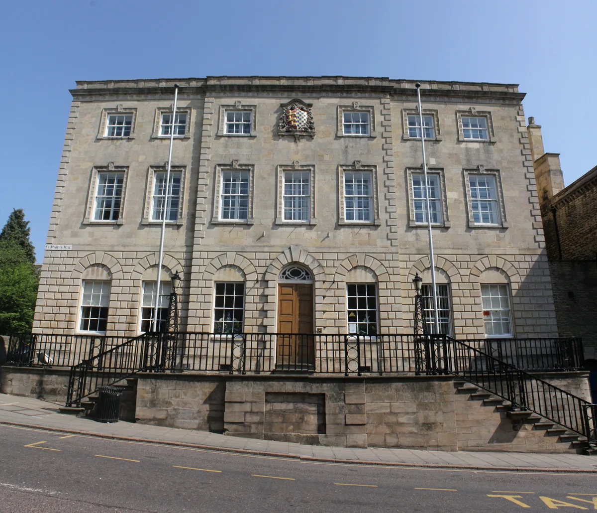
📷 5Museums · East Midlands
Stamford Town Hall
Stamford Town Hall — building in Stamford, Lincolnshire, England, UK.
 📷 5
📷 5Museums · East Midlands
Thorney Museum
Thorney Museum — a museum in england-london, United Kingdom.
 📷 5
📷 5Museums · East Midlands
Octavia Hill Birthplace Museum
Octavia Hill Birthplace Museum — a museum in england-london, United Kingdom.
 📷 5
📷 5Museums · East Midlands
Museum of Technology
Museum of Technology — a museum in england-london, United Kingdom.
Frequently asked questions
- Where is Netherfield, Nottinghamshire?
- Netherfield, Nottinghamshire is in Nottinghamshire, the East Midlands, United Kingdom (postcode NG4 2HG), in the parish of Gedling, unparished area.
- What is Netherfield, Nottinghamshire?
- Netherfield is a town in the Borough of Gedling in Nottinghamshire, England. It is situated to the east of Nottingham's city boundary and is approximately 3 miles (4.8 km) between Colwick and Carlton
- How do I get to Netherfield, Nottinghamshire?
- The nearest railway station is Carlton, about 0.2 km away. Drivers can use postcode NG4 2HG.
- How do I get to Netherfield, Nottinghamshire?
- The nearest railway station is Carlton, about 0.2 km away. Drivers can navigate to postcode NG4 2HG.