Mountains & hills · Mid Wales
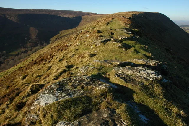
Mynydd Rhyd-galed East Top
Mynydd Rhyd-galed East Top — mountain in wales mid. Elevation: 476 m.

Richard Law — CC BY-SA 2.0 via Wikimedia Commons licence
Plan your visit
- Typical visit
- 3 h–8 h
- Best time of year
- Late spring – early autumn (May–Oct)
About
Mynydd Rhyd-galed East Top is a mountain located in wales mid. Elevation: 476 m. A named British peak recorded in OpenStreetMap. Peaks are typically named on Ordnance Survey 1:50k mapping.
Photo gallery
- Coordinates
- 52.6194, -3.9176
Sources
- osm: n3536187232 (ODbL)
- wikidata: Q20601186 (CC0)
Other places nearby
Loading nearby places…
Nearby
 📷 3
📷 3Mountains & hills · Mid Wales
Mynydd Rhyd-galed East Top
Mynydd Rhyd-galed East Top — a mountain in wales-mid, United Kingdom, 475 m.
📷 5Mountains & hills · Mid Wales
Mynydd Rhyd-galed (Tarrenhendre East Top)
Mynydd Rhyd-galed (Tarrenhendre East Top) — mountain in wales mid. Elevation: 502 m.
📷 5Mountains & hills · Mid Wales
Mynydd Rhyd-galed
Mynydd Rhyd-galed — a hill or mountain in wales mid.
 📷 5
📷 5Mountains & hills · Mid Wales
Mynydd Cefn-caer
Mynydd Cefn-caer — mountain in wales mid. Elevation: 358 m.
 📷 5
📷 5Mountains & hills · Mid Wales
Moel Maes-y-wern-goch
Moel Maes-y-wern-goch — mountain in wales mid. Elevation: 405 m.
 📷 3
📷 3Historic houses · Mid Wales
Upper Dressing Sheds
Upper Dressing Sheds — a historic house in wales-mid, United Kingdom.
Where to eat & stay near Mynydd Rhyd-galed East Top
Places to stay
 📷 5
📷 5Hotels · Mid Wales
Riverside Hotel
Riverside Hotel — a hotel in wales mid.
 📷 5
📷 5Campsites · Mid Wales
Cedis farm
Cedis farm — a campsite in wales mid.
📷 5Campsites · Mid Wales
Cedris Farm Campsite
Cedris Farm Campsite — a campsite in wales mid.
 📷 5
📷 5Caravan parks · Mid Wales
Gwerniago Campsite
Gwerniago Campsite — a caravan park in wales mid.
 📷 5
📷 5Campsites · Mid Wales
Llwyngwern Farm
Llwyngwern Farm — a campsite in wales mid.
 📷 5
📷 5Hostels · Mid Wales
Toad Hall
Toad Hall — a hostel in wales mid.
Places to eat & drink
 📷 5
📷 5Restaurants · Mid Wales
The White Lion Hotel
The White Lion Hotel — a restaurant in wales mid.
 📷 5
📷 5Restaurants · Mid Wales
The Wildfowler
The Wildfowler — a restaurant in wales mid.
 📷 5
📷 5Restaurants · Mid Wales
Penrhyn Bar and Grill
Penrhyn Bar and Grill — a restaurant in wales mid.
 📷 4
📷 4Historic pubs · Mid Wales
Cemmaes
Cemmaes in Wales Mid, United Kingdom.
 📷 5
📷 5Cafés · North Wales
Y Sospan
Y Sospan — a café in wales north.
 📷 5
📷 5Cafés · North Wales
T.H. Roberts
T.H. Roberts — a café in wales north.
More mountains in this region
 📷 3
📷 3Mountains & hills · Mid Wales
Black Hill
Black Hill — Named summit at 640 m.
 📷 3
📷 3Mountains & hills · Mid Wales
Black Mixen
Black Mixen — Named summit at 650 m.
 📷 5
📷 5Mountains & hills · Mid Wales
Cadair Idris
Cadair Idris — Named summit at 893 m.
 📷 3
📷 3Mountains & hills · Mid Wales
Caer Caradoc
Caer Caradoc — Named summit at 459 m.
Frequently asked questions
- Where is Mynydd Rhyd-galed East Top?
- Mynydd Rhyd-galed East Top is in Mid Wales, United Kingdom.
- What is Mynydd Rhyd-galed East Top?
- Mynydd Rhyd-galed East Top — mountain in wales mid. Elevation: 476 m.
- How do I get to Mynydd Rhyd-galed East Top?
- Its coordinates are 52.6194°, -3.9176°.