Lighthouses · Scottish Islands
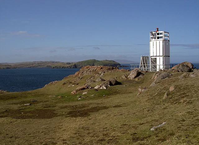
Murbie Stacks Light
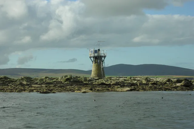
Murbie Stacks Light — a lighthouse in scotland islands.

David Purchase — CC BY-SA 2.0 via Wikimedia Commons licence
Plan your visit
- Typical visit
- 30 min–1 h
About
Murbie Stacks Light is a named lighthouse in scotland islands, recorded in the GeoNames UK gazetteer. British landmarks of this type are typically marked on Ordnance Survey maps and recorded in the national gazetteer for cartographic and navigational reference. Coordinates and feature classification are sourced from the GeoNames open dataset.
Photo gallery
Place summary
Murbie Stacks Light is a lighthouse located in the Scottish Islands. It serves as a navigational aid, marking the Murbie Stacks. The structure is significant for maritime safety in the surrounding waters. Visitors can appreciate its functionality and historical importance in the context of Scottish coastal navigation.
AI-generated from the structured facts on this page (operator, designation, listing, era). Not a substitute for visiting.
- Coordinates
- 60.3492, -1.4507
Sources
- manual: geonames-11611016 (CC BY 4.0)
Other places nearby
Loading nearby places…
Nearby
 📷 3
📷 3Lighthouses · Scottish Islands
Muckle Roe lighthouse
Muckle Roe lighthouse — lighthouse in Shetland Islands, Scotland, UK.
📷 5Mountains & hills · Scottish Islands
Hill of Tongues
Hill of Tongues — mountain in scotland islands. Elevation: 80 m.
 📷 5
📷 5Mountains & hills · Scottish Islands
Muckla Field
Muckla Field — mountain in scotland islands. Elevation: 142 m.
 📷 5
📷 5Mountains & hills · Scottish Islands
Brunt Hill
Brunt Hill — mountain in scotland islands. Elevation: 115 m.
📷 5Vineyards · Scottish Islands
Bungil
Bungil — a UK vineyard in scotland islands, producing English or Welsh wine from cool-climate grape varieties.
📷 5Mountains & hills · Scottish Islands
Muckla Field
Muckla Field — mountain in scotland islands. Elevation: 142 m.
Where to eat & stay near Murbie Stacks Light
Places to stay
 📷 5
📷 5Hostels · Scottish Islands
The Sail Loft
The Sail Loft — a hostel in scotland islands.
 📷 5
📷 5Caravan parks · Scottish Islands
Braewick Caravan Park
Braewick Caravan Park — a caravan park in scotland islands.
 📷 5
📷 5Campsites · Scottish Islands
Skeld Caravan Park and Campsite
Skeld Caravan Park and Campsite — a campsite in scotland islands.
 📷 5
📷 5Campsites · Scottish Islands
South Nesting
South Nesting — a campsite in scotland islands.
 📷 5
📷 5Caravan parks · Scottish Islands
Scalloway Caravan Park
Scalloway Caravan Park — a caravan park in scotland islands.


More lighthouses in this region
 📷 3
📷 3Lighthouses · Scottish Islands
Auskerry Lighthouse
Auskerry Lighthouse — lighthouse in Orkney Islands, Scotland, UK.
 📷 3
📷 3Lighthouses · Scottish Islands
Baa Taing lighthouse
Baa Taing lighthouse — lighthouse in Shetland Islands, Scotland, UK.
 📷 3
📷 3Lighthouses · Scottish Islands
Balta Sound Lighthouse
Balta Sound Lighthouse — lighthouse on the south tip of Balta, Shetland Islands, Scotland, UK.
 📷 3
📷 3Lighthouses · Scottish Islands
Barrel of Butter lighthouse
Barrel of Butter lighthouse — lighthouse in Orkney Islands, Scotland, UK.
Frequently asked questions
- Where is Murbie Stacks Light?
- Murbie Stacks Light is in the Scottish Islands, United Kingdom.
- What is Murbie Stacks Light?
- Murbie Stacks Light — a lighthouse in scotland islands.
- How do I get to Murbie Stacks Light?
- Its coordinates are 60.3492°, -1.4507°.