
Natural landmarks · Northern Ireland
Mourne Wall
Also known as: Balla an Mhúrn
In or near Kilcoo.
Mourne Wall in Northern Ireland, United Kingdom.

Eric Jones — CC BY-SA 2.0 via Wikimedia Commons licence

Plan your visit
- Typical visit
- 1 h–2 h
- Free entry
- Dog-friendly
About
Mourne Wall is a place of interest in Northern Ireland, United Kingdom — drawn from open-data sources for visitor reference. See the linked Wikipedia article for the full description.
Photo gallery
From the Wikipedia article
The Mourne Wall was constructed to enclose a catchment area of the Silent Valley Reservoir in the Mourne Mountains, Northern Ireland. The 1.5 m (4 ft 11 in) high stone wall, which was built to keep livestock from contaminating water supplies, took almost twenty years to complete (1904 to 1922). The project was overseen by the Belfast City and District Water Commissioners.
Excerpt from Wikipedia under CC BY-SA 4.0. See the source article linked in Sources below.
Background
Architecture
, where a trig point stands upon the summit tower]] The wall was built from natural granite stone using traditional dry stone walling techniques. On average the wall is about 1.5 m high and 0.8 to thick and is estimated to be 19.5 mi long. Stonemasons worked from March to mid-October for 18 years to build the wall.
Sourced from Wikipedia under CC BY-SA 4.0.
- Coordinates
- 54.1390, -6.0030
- Established
- 1900
Sources
- wikidata: Q1543119 (CC0)
- wikipedia: Mourne Wall (CC BY-SA 4.0)
Other places nearby

Binnian Tunnel
Natural landmarks · 0.5 km

Silent Valley Reservoir
Reservoirs & lochs · 0.7 km

Slievenaglogh
Mountains & hills · 0.7 km

Broinn Bhinneain
Mountains & hills · 1.1 km

Wee Binnian
Mountains & hills · 1.2 km

Moolieve Mountain
Viewpoints · 1.3 km
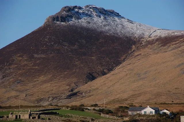
Slieve Binnian
Natural landmarks · 1.5 km
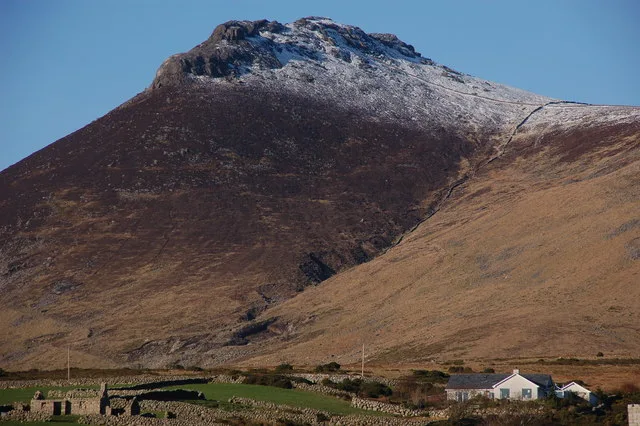
Slieve Binnian
Mountains & hills · 1.5 km

The Mourne Hand
Public art & sculpture · 1.8 km

Slieve Binnian North Top
Mountains & hills · 1.8 km
Slieve Binnian North Top
Mountains & hills · 1.9 km

Ben Crom Reservoir
Reservoirs & lochs · 2.0 km
Nearby
📷 4Natural landmarks · Northern Ireland
Binnian Tunnel
Binnian Tunnel in Northern Ireland, United Kingdom.
📷 3Reservoirs & lochs · Northern Ireland
Silent Valley Reservoir
Silent Valley Reservoir — reservoir in County Down, Northern Ireland, UK.
📷 5Mountains & hills · Northern Ireland
Slievenaglogh
Slievenaglogh — mountain in northern ireland. Elevation: 445 m.
📷 5Mountains & hills · Northern Ireland
Broinn Bhinneain
Broinn Bhinneain — a hill or mountain in northern ireland.
📷 5Mountains & hills · Northern Ireland
Wee Binnian
Wee Binnian — mountain in northern ireland. Elevation: 460 m.
📷 3Viewpoints · Northern Ireland
Moolieve Mountain
Moolieve Mountain is a viewpoint in the United Kingdom.
Where to eat & stay near Mourne Wall
Places to stay
 📷 5
📷 5Campsites · Northern Ireland
Carrick Little Glamping
Carrick Little Glamping — a campsite in northern ireland.
 📷 5
📷 5 📷 5
📷 5Caravan parks · Northern Ireland
Annalong Caravan Park
Annalong Caravan Park — a caravan park in northern ireland.
 📷 5📷 5
 📷 5
📷 5Caravan parks · Northern Ireland
The Rock Caravan Site
The Rock Caravan Site — a caravan park in northern ireland.
Places to eat & drink
 📷 3
📷 3Historic pubs · Northern Ireland
Soma Festival
The Soma Festival (Sanskrit: सोम, or sóma, meaning drink of the Gods, see Soma (drink); Irish: Féile Soma) is an annual music, arts, and cultural festival. The festival includes concerts, musical perf
More natural landmarks in this region
 Flagship📷 4
Natural landmarks · Northern Ireland
Lough Erne
Lough Erne — lake in County Fermanagh, Northern Ireland, UK.
 Flagship📷 4
Natural landmarks · Northern Ireland
Lough Neagh
Lough Neagh — large lake in Northern Ireland.
 📷 3
📷 3Natural landmarks · Northern Ireland
Ballysaggart Lough
Ballysaggart Lough — lake in the United Kingdom.
 📷 5
📷 5Natural landmarks · Northern Ireland
Belmore Mountain
Belmore Mountain — mountain in the United Kingdom.
Frequently asked questions
- Where is Mourne Wall?
- Mourne Wall is in Northern Ireland, United Kingdom.
- What is Mourne Wall?
- Mourne Wall in Northern Ireland, United Kingdom.
- How do I get to Mourne Wall?
- Its coordinates are 54.1390°, -6.0030°.
- When was Mourne Wall built?
- Built or established in 1900.
- Is Mourne Wall free to visit?
- Yes, Mourne Wall is free to enter.