
Caves · South East England
Mother Ludlam's Cave
In or near Wrecclesham.
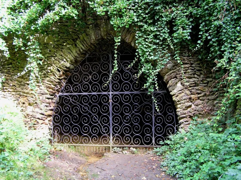
Mother Ludlam's Cave is a cave in the United Kingdom.

Wikimedia Commons contributors — see linked file page for photographer and licence licence

Plan your visit
- Typical visit
- 45 min–1.5 h
- Nearest railway station
- Mills Wood · 2.6 km
- Free entry
- Dog-friendly
Getting there & planning your visit
To visit Mother Ludlam's Cave, the nearest railway station is Mills Wood, located 2.6 km away. The postcode for sat-nav is GU10 1RJ, and entry to the cave is free.
About
Mother Ludlam's Cave is a named cave entrance in the United Kingdom. Coordinates: 51.2044°, -0.7550°. This entry is part of The Great Britain Guide, a free, ad-free, open-data tourist directory.
Photo gallery
Protected designations
- Site of Special Scientific Interest: Moor Park SSSI
- National Nature Reserve: WEALDEN HEATHS
- Area of Outstanding Natural Beauty: Surrey Hills
Designations sourced from Natural England open data under OGL v3.
From the Wikipedia article
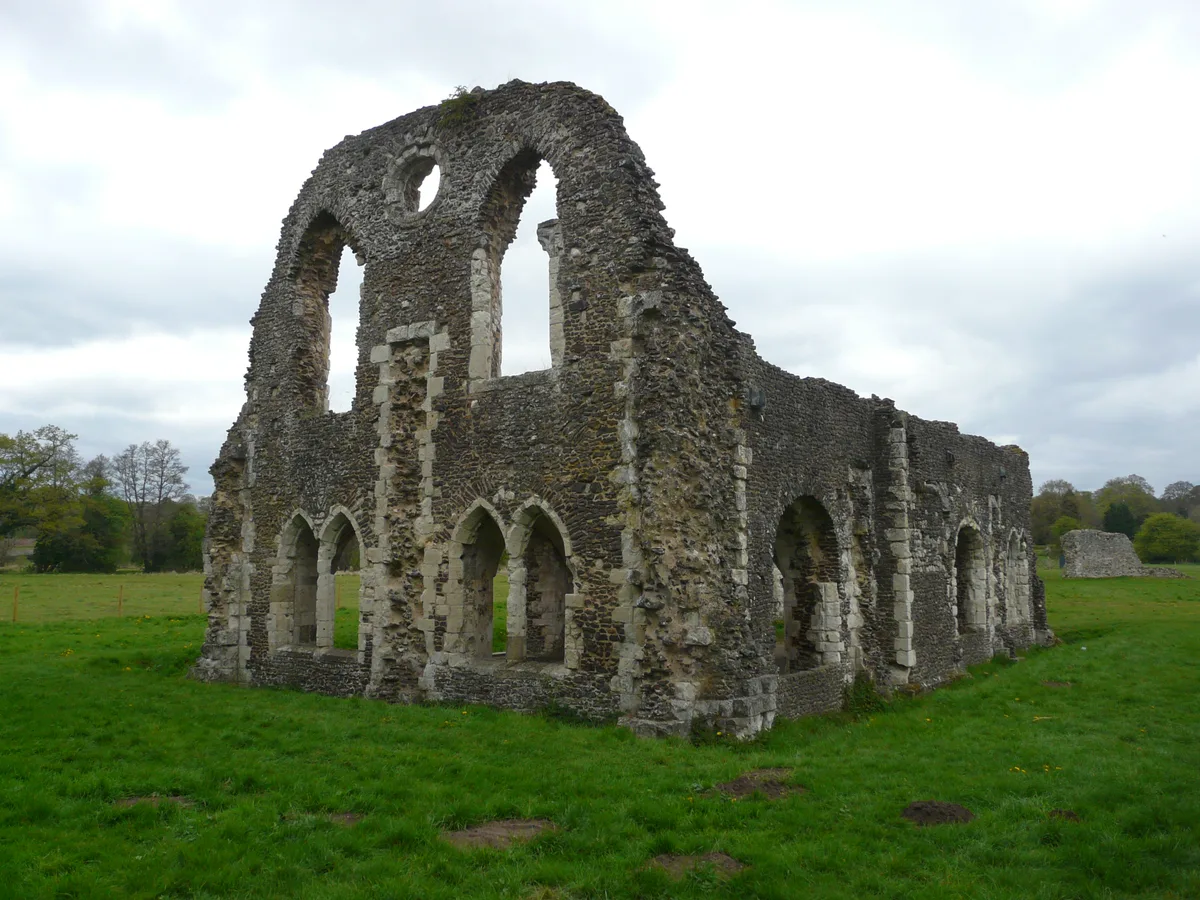
Mother Ludlam's Cave, also known as Mother Ludlum's Cave or Mother Ludlum's Hole, is a small cave in the sandstone cliff of the Wey Valley at Moor Park, near Farnham, Surrey, in England. The cave is the subject of a number of local legends. A spring rising in the cave is recorded in the 13th century "Annals of Waverley Abbey" as "Ludewell"; other spellings through history include "Ludwell" and "Luddwelle". A monk named Symon is credited with identifying the spring as a suitable water supply for Waverley Abbey in 1218, after the original source had dried up. The brothers of the abbey dedicated the spring to St Mary, so it also became known as St Mary's Well. The cave has been naturally formed by the spring but may have been enlarged by the monks and was made into a grotto (possibly during the eighteenth century) and further enhanced by addition of an ironstone arched entrance, possibly during the reign of Queen Victoria. The cave was explored and surveyed at around 200 feet long in 1945 and as 192 feet to a recent roof collapse in 1961.
Excerpt from Wikipedia under CC BY-SA 4.0. See the source article linked in Sources below.
Background
History
According to the information panel erected at the cave by Waverley Borough Council the name Ludwell can be traced back to the Celtic language, and means "bubbling spring". John Aubrey visited the area in 1673 and was informed that Ludwell was named after Lud, King of the South Saxons, who went there to bathe his wounds after a battle. A story originating with the Norman-Welsh writer of historicised legends Geoffrey of Monmouth has Ludd, Lud or Llud as the ruler of Celtic Britain. Geoffrey suggested that London, originally called Trinovantum, was renamed for King Lud and known as Lud's Dun (Dun is celtic for Castle or Hillfort) which became London. The western gate of the City of London is…
Description
The cave has long been associated with the legend of "Mother Ludlam" who was, supposedly, a white witch who lived in the cave. The earliest versions of the legend, such as that recorded by John Aubrey in 1673 in his Natural History and Antiquities of Surrey, make no mention of a witch and it is likely that the story was originally associated with fairies. Various versions of the legend have existed. The simplest version is that Mother Ludlam would loan utensils and that a large cauldron was borrowed but not returned; she became enraged and the borrower, scared by her anger, sought refuge in Frensham Church. The cauldron associated with this legend remains in the church to this day, but is…
Sourced from Wikipedia under CC BY-SA 4.0.
- Coordinates
- 51.2044, -0.7550
- County
- Surrey
- District
- Waverley
- Parish
- Farnham
- Postcode
- GU10 1RJ
- Parliamentary constituency
- Farnham and Bordon
- Nearest railway station
- Mills Wood — 2.6 km
Sources
- osm: n4911277523 (ODbL)
- wikipedia: Mother Ludlam's Cave (CC BY-SA 4.0)
- commons: Mother Ludlam's Cave 2005.jpg (CC BY-SA 4.0)
Other places nearby
Mother Ludlam's Cave
Mountains & hills · 0.0 km
Waverley Abbey
Abbeys & priories · 0.5 km

Waverley Abbey
Cathedrals · 0.5 km

Crooksbury Hill
Mountains & hills · 0.7 km
Crooksbury Hill
Mountains & hills · 0.8 km

Crooksbury Hill Trig Point
Viewpoints · 0.8 km

Herons Wey Campsite
Campsites · 0.9 km

Soldiers Ring
Forts · 1.0 km

Moor Park
Gardens · 1.0 km
Soldier's Ring hillfort
Vineyards · 1.0 km
Runfold Wood
Wildlife reserves · 1.1 km
Garners Field Campsite
Campsites · 1.1 km
Nearby
📷 5Mountains & hills · South East England
Mother Ludlam's Cave
Mother Ludlam's Cave — cave in Farnham, Surrey, UK.
★ Iconic📷 5Abbeys & priories · South East England
Waverley Abbey
Waverley Abbey — Cistercian abbey in Surrey, England, UK.
📷 5Cathedrals · South East England
Waverley Abbey
Waverley Abbey is a cathedral in the United Kingdom.
📷 5Mountains & hills · South East England
Crooksbury Hill
Crooksbury Hill — a hill or mountain in england south east.
📷 5Mountains & hills · South East England
Crooksbury Hill
Crooksbury Hill — mountain in england south east.
📷 5Viewpoints · South East England
Crooksbury Hill Trig Point
Crooksbury Hill Trig Point is a viewpoint in the United Kingdom.
Where to eat & stay near Mother Ludlam's Cave
Places to stay
📷 5Campsites · South East England
Herons Wey Campsite
Herons Wey Campsite — a campsite in england south east.
📷 5Campsites · South East England
Garners Field Campsite
Garners Field Campsite — a campsite in england south east.
 📷 5
📷 5 📷 5
📷 5Campsites · South East England
Waggoners
Waggoners — a campsite in england south east.
 📷 5
📷 5Hostels · South East England
Puttenham Barn Bunkhouse
Puttenham Barn Bunkhouse — a hostel in england south east.
 📷 5
📷 5Campsites · South East England
Runways End Outdoor Centre
Runways End Outdoor Centre — a campsite in england south east.
Places to eat & drink
 📷 7
📷 7Historic pubs · South East England
The Fox Public House
The Fox Public House in England South East, United Kingdom.
 📷 7
📷 7Historic pubs · South East England
William Cobbett Public House
William Cobbett Public House in England South East, United Kingdom.
 📷 7
📷 7Historic pubs · South East England
8 And 9 (The Queens Head), The Borough
8 And 9 (The Queens Head), The Borough in England South East, United Kingdom.
 📷 7
📷 7Restaurants · South East England
The Bengal Lounge
The Bengal Lounge — a restaurant in england south east.
 📷 5
📷 5Historic pubs · South East England
The Stag on the River
The Stag on the River in England South East, United Kingdom.
 📷 7
📷 7Historic pubs · South East England
The Star Public House
The Star Public House in England South East, United Kingdom.
More caves in this region
 📷 5
📷 5Caves · South East England
Godstone Mines
Godstone Mines is a cave in the United Kingdom.
 📷 5
📷 5Caves · South East England
Hermit's Cave
Hermit's Cave is a cave in the United Kingdom.
 📷 5
📷 5Caves · South East England
Barons Cave
Barons Cave — a cave in england-london, United Kingdom.
 📷 5
📷 5Frequently asked questions
- Where is Mother Ludlam's Cave?
- Mother Ludlam's Cave is in Surrey, South-East England, United Kingdom (postcode GU10 1RJ), in the parish of Farnham.
- What is Mother Ludlam's Cave?
- Mother Ludlam's Cave is a cave in the United Kingdom.
- How do I get to Mother Ludlam's Cave?
- The nearest railway station is Mills Wood, about 2.6 km away. Drivers can use postcode GU10 1RJ.
- Is Mother Ludlam's Cave a protected site?
- Yes — Mother Ludlam's Cave is part of the Moor Park SSSI Site of Special Scientific Interest and the WEALDEN HEATHS National Nature Reserve.
- Is Mother Ludlam's Cave free to visit?
- Yes, Mother Ludlam's Cave is free to enter.
- How do I get to Mother Ludlam's Cave?
- The nearest railway station is Mills Wood, about 2.6 km away. Drivers can navigate to postcode GU10 1RJ.