Wildlife reserves · Mid Wales
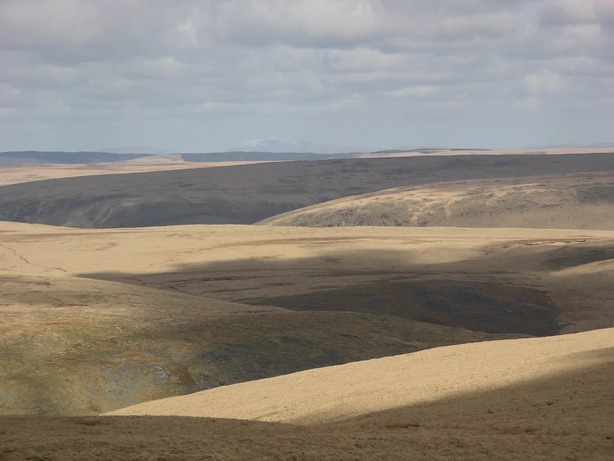
Monks Trod
In or near Rhayader Town F.C..
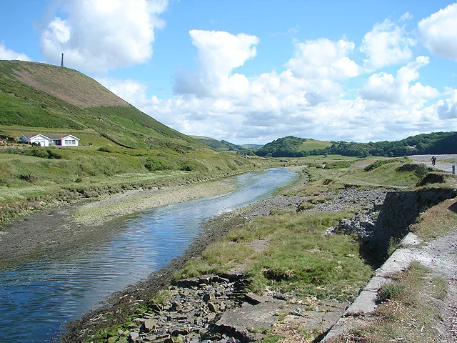
Monks Trod in Wales Mid, United Kingdom.

Ian Medcalf — CC BY-SA 2.0 via Wikimedia Commons licence
Plan your visit
- Typical visit
- 2 h–4 h
- Best time of year
- Autumn & winter (migration & wildfowl)
- Free entry
- Dog-friendly
About
Monks Trod is a place of interest in Wales Mid, United Kingdom — drawn from open-data sources for visitor reference. See the linked Wikipedia article for the full description.
From the Wikipedia article
Monks Trod is a byway open to all traffic in Wales, developed originally by Cistercian monks between the twelfth century abbeys of Cwm-Hir, near Llandrindod Wells, and Strata Florida, near Tregaron, Ceredigion. Monks Trod runs for more than 5 miles (8.0 km) in Powys as a byway across the Cambrian mountains, and then crosses into Ceredigion, becoming a 1 mile (1.6 km) stretch of unclassified road. The 6 miles (9.7 km) section between Pont ar Elan beside the Craig Goch Dam reservoir, and Strata Florida passes over a natural peat moorland, designated as a National Nature Reserve Claerwen (NNR), Site of Special Scientific Interest (Elenydd SSSI), Special Protection Area (Elenydd – Mallaen), and a Special Area of Conservation. In 1990, as a result of widespread damage to the SSSI section, a Traffic Regulation Order (TRO) was placed on the Monks' Trod, banning four-wheeled vehicles only. In 2002 a temporary TRO was imposed, banning all motor traffic, including motorcycles. The TRO banning motorcycles came to an end on 20 October 2021, and it is currently, once again, legally open to vehicles with two wheels. While the TRO was in place, Natural Resources Wales along with independent ecological specialists looked at the likely effects of carrying out surfacing and drainage work on the iconic byway which is notorious for its boggy and difficult ground. A complex environmental assessment – known as a Habitat Regulations Assessment – was carried out, to identify what effect any proposed repairs and improvements to the route within Powys might have on the whole of the area, which is designated as a Special Area for Conservation. The assessment concluded that the council will not be able to proceed with any proposed surfacing works at this current time. The status of the byway is under constant review, and user groups are encouraged to be ever-mindful that if the route is not respected, then it is likely to be permanently closed. It is estimated that it would cost in excess of…
Excerpt from Wikipedia under CC BY-SA 4.0. See the source article linked in Sources below.
- Coordinates
- 52.3138, -3.6790
Sources
- wikidata: Q6900951 (CC0)
- wikipedia: Monks Trod (CC BY-SA 4.0)
Other places nearby

Clawdd Du Mawr
Mountains & hills · 0.8 km

Blaen Rhestr
Mountains & hills · 1.3 km
![Priddellau [Esgair Nantybeddau]](https://upload.wikimedia.org/wikipedia/commons/a/a8/Trumau_-_geograph.org.uk_-_1167178.jpg?utm_source=commons.wikimedia.org&utm_campaign=imageinfo&utm_content=thumbnail_unscaled)
Priddellau [Esgair Nantybeddau]
Mountains & hills · 2.0 km

Pant-llwyd
Mountains & hills · 2.4 km

Pant-llwyd (old GR)
Mountains & hills · 2.4 km
Desert of Wales
Natural landmarks · 2.9 km

Craig-yr-allt gôch Reservoir
Reservoirs & lochs · 3.1 km

Claerwen Reservoir
Reservoirs & lochs · 3.4 km

Llethr Hir
Mountains & hills · 3.5 km

Craig Goch Dam
Reservoirs & lochs · 3.9 km
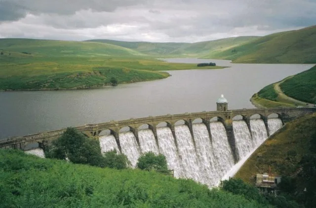
Craig Goch Reservoir
Reservoirs & lochs · 3.9 km

Talar Wen Quarry
Quarries · 4.1 km
Nearby
📷 3Mountains & hills · Mid Wales
Clawdd Du Mawr
Clawdd Du Mawr — a mountain in wales-mid, United Kingdom, 535 m.
📷 3Mountains & hills · Mid Wales
Blaen Rhestr
Blaen Rhestr — a mountain in wales-mid, United Kingdom, 547 m.
📷 3Mountains & hills · Mid Wales
Priddellau [Esgair Nantybeddau]
Priddellau [Esgair Nantybeddau] — a mountain in wales-mid, United Kingdom, 534 m.
📷 5📷 3Mountains & hills · Mid Wales
Pant-llwyd (old GR)
Pant-llwyd (old GR) — a mountain in wales-mid, United Kingdom, 548 m.
📷 3Where to eat & stay near Monks Trod
Places to stay
 📷 5
📷 5 📷 5
📷 5Caravan parks · Mid Wales
Glangwy Farm Camping
Glangwy Farm Camping — a caravan park in wales mid.
 📷 5
📷 5Campsites · Mid Wales
Wyeside Caravan & Camping Park
Wyeside Caravan & Camping Park — a campsite in wales mid.
 📷 7
📷 7 📷 7
📷 7 📷 5
📷 5Places to eat & drink
 📷 5
📷 5 📷 5
📷 5Cafés · Mid Wales
Llywernog Silver Lead Mine
Llywernog Silver Lead Mine — a café in wales mid.
 📷 7
📷 7More places in this region
 📷 5
📷 5Wildlife reserves · Mid Wales
Ynys-hir RSPB reserve
Ynys-hir RSPB reserve — RSPB nature reserve, situated beside the Dyfi estuary in Ceredigion, mid Wales.
 📷 3
📷 3Wildlife reserves · Mid Wales
Dyfi National Nature Reserve
Dyfi National Nature Reserve is a wildlife reserve in the United Kingdom.
 📷 3
📷 3Wildlife reserves · Mid Wales
Penglais Nature Park
Penglais Nature Park is a wildlife reserve in the United Kingdom.
 📷 3
📷 3Wildlife reserves · Mid Wales
Tan-y-Bwlch, Aberystwyth
Tan-y-Bwlch, Aberystwyth — nature reserve near Aberystwyth, Wales.
Frequently asked questions
- Where is Monks Trod?
- Monks Trod is in Mid Wales, United Kingdom.
- What is Monks Trod?
- Monks Trod in Wales Mid, United Kingdom.
- How do I get to Monks Trod?
- Its coordinates are 52.3138°, -3.6790°.
- Is Monks Trod free to visit?
- Yes, Monks Trod is free to enter.
- Are dogs allowed at Monks Trod?
- Most wildlife reserves allow dogs on lead only, with restrictions during ground-nesting bird season (March-July). Check signage at the reserve.