
Historic houses · Yorkshire & the Humber
Medieval standing cross on Tanpit Lane, 150m west of Wentbank House
In or near Norton.
Medieval standing cross on Tanpit Lane, 150m west of Wentbank House — a Grade II-listed historic house in england-yorkshire, United Kingdom.

JThomas — CC BY-SA 2.0 via Wikimedia Commons licence

Plan your visit
- Typical visit
- 1 h–2 h
- Nearest railway station
- Whitley Bridge · 6.6 km
- Family-friendly
- Limited wheelchair access
About
Medieval standing cross on Tanpit Lane, 150m west of Wentbank House is a Grade II-listed building in england-yorkshire, United Kingdom. Grade II status is conferred by Historic England (or Cadw, Historic Environment Scotland or NIEA equivalents) on buildings of exceptional national interest. See the linked Wikipedia article for full historical and architectural details.
Photo gallery
Place summary
The Medieval standing cross on Tanpit Lane, located 150m west of Wentbank House in Yorkshire, is a historic monument designated as Grade II*. It is situated within the parish of Norton and reflects the region's medieval heritage.
AI-generated from the structured facts on this page (operator, designation, listing, era). Not a substitute for visiting.
- Coordinates
- 53.6406, -1.1732
- District
- Doncaster
- Parish
- Norton
- Postcode
- DN6 9BF
- Parliamentary constituency
- Doncaster North
- Nearest railway station
- Whitley Bridge — 6.6 km
Sources
- wikidata: Q17676339 (CC0)
Other places nearby

Tanpit Bridge
Historic bridges · 0.1 km

Norton
Towns & cities · 0.9 km

Bridge Across Ings Dike Approximately 200 Metres To South Of North Common Farm
Historic bridges · 1.9 km

Campsmount Academy
Natural landmarks · 2.0 km
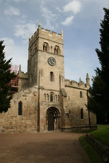
St Mary Magdalene, Campsall
Historic churches · 2.3 km

Bridge At South Entrance To Farmyard Of Campsmount Home Farm
Historic bridges · 2.4 km

Little Smeaton Art Gallery
Galleries · 2.6 km

Kirk and Little Smeaton War Memorial
Memorials & monuments · 2.8 km

Kirk Smeaton
Villages · 3.0 km

Womersley Park and adjoining coach-house and stables
Historic houses · 3.0 km

Church of St Martin
Historic churches · 3.1 km

Askern
Museums · 3.1 km
Nearby
📷 3Historic bridges · Yorkshire & the Humber
Tanpit Bridge
Tanpit Bridge is a historic bridge in the United Kingdom.
📷 4Towns & cities · Yorkshire & the Humber
Norton
Norton — village and civil parish in Doncaster, South Yorkshire, England.
📷 3Historic bridges · Yorkshire & the Humber
Bridge Across Ings Dike Approximately 200 Metres To South Of North Common Farm
Bridge Across Ings Dike Approximately 200 Metres To South Of North Common Farm — Grade II listed building-listed bridge in england-yorkshire, United Kingdom.
📷 5Natural landmarks · Yorkshire & the Humber
Campsmount Academy
Campsmount Academy — a school heritage in england-yorkshire, United Kingdom.
📷 5Historic churches · Yorkshire & the Humber
St Mary Magdalene, Campsall
St Mary Magdalene, Campsall — Grade I listed church in Norton, Doncaster, South Yorkshire, England, UK.
📷 3Historic bridges · Yorkshire & the Humber
Bridge At South Entrance To Farmyard Of Campsmount Home Farm
Bridge At South Entrance To Farmyard Of Campsmount Home Farm — Grade II listed building-listed bridge in england-yorkshire, United Kingdom.
Where to eat & stay near Medieval standing cross on Tanpit Lane, 150m west of Wentbank House
Places to stay
 📷 6
📷 6 📷 5
📷 5Caravan parks · Yorkshire & the Humber
Tilts Farm Caravan Site
Tilts Farm Caravan Site — a caravan park in england yorkshire.
 📷 5
📷 5Caravan parks · Yorkshire & the Humber
The Pony Paddock
The Pony Paddock — a caravan park in england yorkshire.
 📷 5
📷 5Caravan parks · Yorkshire & the Humber
Riverside Mobile Home Park
Riverside Mobile Home Park — a caravan park in england yorkshire.
 📷 5
📷 5Campsites · Yorkshire & the Humber
Sloop Inn Campsite
Sloop Inn Campsite — a campsite in england yorkshire.
 📷 5
📷 5Caravan parks · Yorkshire & the Humber
The Stables Caravan Park
The Stables Caravan Park — a caravan park in england yorkshire.
Places to eat & drink
 📷 7
📷 7Historic pubs · Yorkshire & the Humber
The Horse Vaults Public House
The Horse Vaults Public House in England Yorkshire, United Kingdom.
 📷 7
📷 7Historic pubs · Yorkshire & the Humber
The Green Dragon Public House
The Green Dragon Public House in England Yorkshire, United Kingdom.
 📷 7
📷 7Historic pubs · Yorkshire & the Humber
The Plough Inn
The Plough Inn in England Yorkshire, United Kingdom.
 📷 7
📷 7Historic pubs · Yorkshire & the Humber
Pontefract Barracks
Pontefract Barracks in England Yorkshire, United Kingdom.
 📷 7
📷 7Restaurants · East Midlands
Miller & Carter
Miller & Carter — a restaurant in england east midlands. Cuisine: steak. Brand: Miller & Carter.
 📷 5
📷 5Historic pubs · Yorkshire & the Humber
The Commercial
The Commercial in England Yorkshire, United Kingdom.
More historic houses in this region
 📷 3
📷 3Historic houses · Yorkshire & the Humber
213, Chestergate
213, Chestergate — Grade II listed house in Stockport, Greater Manchester, England, UK.
 📷 3
📷 3Historic houses · Yorkshire & the Humber
96, Churchgate
96, Churchgate — Grade II listed house in Stockport, Greater Manchester, England, UK.
 📷 3
📷 3Historic houses · Yorkshire & the Humber
Broadbottom Hall
Broadbottom Hall — Grade II* listed house in Broadbottom, Tameside, Greater Manchester, England, UK.
.jpg?width=1200) 📷 3
📷 3Historic houses · Yorkshire & the Humber
Charles Head House
Charles Head House — house in Rainow, Cheshire East, England, UK.
Frequently asked questions
- Where is Medieval standing cross on Tanpit Lane, 150m west of Wentbank House?
- Medieval standing cross on Tanpit Lane, 150m west of Wentbank House is in Yorkshire, United Kingdom (postcode DN6 9BF), in the parish of Norton.
- What is Medieval standing cross on Tanpit Lane, 150m west of Wentbank House?
- Medieval standing cross on Tanpit Lane, 150m west of Wentbank House — a Grade II-listed historic house in england-yorkshire, United Kingdom.
- How do I get to Medieval standing cross on Tanpit Lane, 150m west of Wentbank House?
- The nearest railway station is Whitley Bridge, about 6.6 km away. The nearest town is Norton. Drivers can use postcode DN6 9BF.
- Is Medieval standing cross on Tanpit Lane, 150m west of Wentbank House a listed building?
- Medieval standing cross on Tanpit Lane, 150m west of Wentbank House is officially recognised as Grade II listed.
- How do I get to Medieval standing cross on Tanpit Lane, 150m west of Wentbank House?
- The nearest railway station is Whitley Bridge, about 6.6 km away. Drivers can navigate to postcode DN6 9BF.