
Literary houses · South West England
Medieval defensive and settlement complex at Taynton Parva, 400m north west of Moorfields Farm
In or near Luxley.
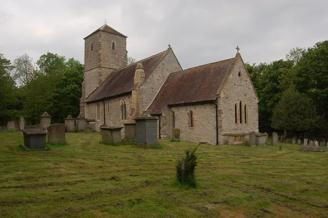
Medieval defensive and settlement complex at Taynton Parva, 400m north west of Moorfields Farm — a literary house museum in england west midlands.

Peter Whatley — CC BY-SA 2.0 via Wikimedia Commons licence

Plan your visit
- Typical visit
- 1 h–1.5 h
- Nearest railway station
- Gloucester · 9.9 km
- Wheelchair accessible
About
Medieval defensive and settlement complex at Taynton Parva, 400m north west of Moorfields Farm is a literary house museum located in england west midlands. A British literary house preserving the home of a notable author, poet or playwright as a museum, often with original furniture and manuscripts. archaeological site in Taynton, Gloucestershire, England, UK
Photo gallery
Protected designations
- Area of Outstanding Natural Beauty: Cotswolds
Designations sourced from Natural England open data under OGL v3.
Place summary
The Medieval defensive and settlement complex at Taynton Parva is located 400 metres north-west of Moorfields Farm in the West Midlands. This site features remnants of a historic settlement, highlighting its strategic importance during the medieval period. The complex provides insight into the region's past and its defensive architecture. It is an example of the historical landscape that characterises this part of Britain.
AI-generated from the structured facts on this page (operator, designation, listing, era). Not a substitute for visiting.
- Coordinates
- 51.9041, -2.3676
- County
- Gloucestershire
- District
- Forest of Dean
- Parish
- Taynton
- Postcode
- GL19 3AL
- Parliamentary constituency
- Forest of Dean
- Nearest railway station
- Gloucester — 9.9 km
Sources
- wikidata: Q17664064 (CC0)
Other places nearby

Taynton Parva Castle
Castles · 0.0 km
Taynton Parva
Castles · 0.0 km

Tibberton
Villages · 1.3 km

Taynton War Memorial
Memorials & monuments · 1.3 km
Church of the Holy Trinity
Historic churches · 1.4 km

Tom Rogers Adventure Centre
Natural landmarks · 2.1 km

Taynton Village Sign
Public art & sculpture · 2.4 km
Taynton, Gloucestershire
Castles · 2.4 km

Monument To Dead In Civil War Skirmish
Memorials & monuments · 2.6 km

The Dark Barn
Restaurants · 2.6 km

Woodgreen Farm CL
Caravan parks · 3.0 km

Hartpury Mill, The Mill
Watermills · 3.0 km
Nearby
📷 3Castles · South West England
Taynton Parva Castle
Taynton Parva Castle — a castle in South West England, United Kingdom.
📷 5📷 5📷 3Memorials & monuments · South West England
Taynton War Memorial
Taynton War Memorial — Grade II listed building-listed memorial in england-west-midlands, United Kingdom.
📷 3Historic churches · South West England
Church of the Holy Trinity
Church of the Holy Trinity — church in Forest of Dean, UK.
📷 3Natural landmarks · South West England
Tom Rogers Adventure Centre
Tom Rogers Adventure Centre — a place in South West England, United Kingdom.
Where to eat & stay near Medieval defensive and settlement complex at Taynton Parva, 400m north west of Moorfields Farm
Places to stay
📷 5Caravan parks · South West England
Woodgreen Farm CL
Woodgreen Farm CL — a caravan park in england west midlands.
 📷 5
📷 5Campsites · South West England
Pelerine Caravan & Camping Site
Pelerine Caravan & Camping Site — a campsite in england west midlands.
 📷 5
📷 5Campsites · South West England
Forest Road Camping
Forest Road Camping — a campsite in england west midlands.
 📷 5
📷 5Campsites · West Midlands
Haywood Farm Caravan and Camping Park
Haywood Farm Caravan and Camping Park — a campsite in england west midlands.
 📷 5
📷 5Campsites · West Midlands
Greenacres Camping & Caravan Site
Greenacres Camping & Caravan Site — a campsite in england west midlands.
 📷 5
📷 5Campsites · South West England
Court Farm Camping
Court Farm Camping — a campsite in england west midlands.
Places to eat & drink
📷 7Restaurants · South West England
The Dark Barn
The Dark Barn — a restaurant in england west midlands. Cuisine: gastropub. 4-star.
 📷 7
📷 7Historic pubs · South West England
Dick Whittington Tavern
Dick Whittington Tavern in England South East, United Kingdom.
 📷 6
📷 6Historic pubs · South West England
The Pelican Inn
The Pelican Inn in England South East, United Kingdom.
 📷 5
📷 5 📷 5
📷 5Historic pubs · South West England
The Fleece Hotel
The Fleece Hotel in England South East, United Kingdom.
 📷 7
📷 7Historic pubs · South West England
The Tall Ships Public House
The Tall Ships Public House in England South East, United Kingdom.
More places in this region
 📷 5
📷 5Literary houses · South West England
Motte castle 20m west of Great Somerford Church
Motte castle 20m west of Great Somerford Church — a literary house museum in england south east.
 📷 5
📷 5Literary houses · South West England
Medieval fortified house at Castle Hill
Medieval fortified house at Castle Hill — a literary house museum in england south east.
 📷 5
📷 5Literary houses · South West England
Motte castle 150m south of Jubilee Wood, Hartham Park
Motte castle 150m south of Jubilee Wood, Hartham Park — a literary house museum in england south east.
 📷 5
📷 5Literary houses · South West England
Castle mound (or Castle Hill)
Castle mound (or Castle Hill) — a literary house museum in england south east.
Frequently asked questions
- Where is Medieval defensive and settlement complex at Taynton Parva, 400m north west of Moorfields Farm?
- Medieval defensive and settlement complex at Taynton Parva, 400m north west of Moorfields Farm is in Gloucestershire, South-West England, United Kingdom (postcode GL19 3AL), in the parish of Taynton.
- What is Medieval defensive and settlement complex at Taynton Parva, 400m north west of Moorfields Farm?
- Medieval defensive and settlement complex at Taynton Parva, 400m north west of Moorfields Farm — a literary house museum in england west midlands.
- How do I get to Medieval defensive and settlement complex at Taynton Parva, 400m north west of Moorfields Farm?
- The nearest railway station is Gloucester, about 9.9 km away. The nearest town is Luxley. Drivers can use postcode GL19 3AL.
- Is Medieval defensive and settlement complex at Taynton Parva, 400m north west of Moorfields Farm a protected site?
- Yes — Medieval defensive and settlement complex at Taynton Parva, 400m north west of Moorfields Farm is part of the Cotswolds National Landscape (AONB).
- How do I get to Medieval defensive and settlement complex at Taynton Parva, 400m north west of Moorfields Farm?
- Drivers can navigate to postcode GL19 3AL. It sits within the Forest of Dean parliamentary constituency.