Mountains & hills · Scottish Highlands
Meall nan Aighean
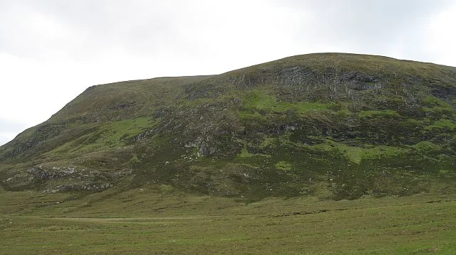
Meall nan Aighean — mountain in scotland highlands. Elevation: 697 m.

Reed Sadler — CC BY-SA 2.0 via Wikimedia Commons licence
Plan your visit
- Typical visit
- 3 h–8 h
- Best time of year
- Late spring – early autumn (May–Oct)
About
Meall nan Aighean is a mountain located in scotland highlands. Elevation: 697 m. A named British peak recorded in OpenStreetMap. Peaks are typically named on Ordnance Survey 1:50k mapping.
Photo gallery
Place summary
Meall nan Aighean is a mountain located in the Scottish Highlands. It is known for its rugged terrain and prominent position in the landscape. The mountain is part of a region characterised by dramatic scenery and offers various walking trails for those seeking to explore its natural beauty. Visitors can expect a remote and tranquil environment, typical of the Highlands.
AI-generated from the structured facts on this page (operator, designation, listing, era). Not a substitute for visiting.
- Coordinates
- 58.2287, -4.2478
Sources
- osm: n2689679399 (ODbL)
Other places nearby
Loading nearby places…
Nearby
📷 4Mountains & hills · Scottish Highlands
Meall nan Aighean
Meall nan Aighean — a hill or mountain in scotland highlands.
📷 3Mountains & hills · Scottish Highlands
Creag na h-Iolaire
Creag na h-Iolaire — mountain in scotland highlands. Elevation: 694 m.
📷 2Mountains & hills · Scottish Highlands
Meall Àrd
Meall Àrd — mountain in scotland highlands. Elevation: 628 m.
 📷 5
📷 5Mountains & hills · Scottish Highlands
Ben Armine
Ben Armine — a hill or mountain in scotland highlands.
 📷 3
📷 3Mountains & hills · Scottish Highlands
Creag a' Choire Ghlais
Creag a' Choire Ghlais — Named summit at 705 m.

Mountains & hills · Scottish Highlands
Meall Meadhon
Meall Meadhon — a hill or mountain in scotland highlands.
Where to eat & stay near Meall nan Aighean
Places to stay
 📷 5
📷 5Campsites · Scottish Highlands
Altnaharra Caravan Club Site
Altnaharra Caravan Club Site — a campsite in scotland highlands.
 📷 5
📷 5Hostels · Scottish Highlands
(Crask Inn)
(Crask Inn) — a hostel in scotland highlands.
 📷 5
📷 5Caravan parks · Scottish Highlands
Woodend Caravan and Camping Site
Woodend Caravan and Camping Site — a caravan park in scotland highlands.
 📷 5
📷 5Campsites · Scottish Highlands
Pondside Camping & Accommodation
Pondside Camping & Accommodation — a campsite in scotland highlands.
 📷 5
📷 5Caravan parks · Scottish Highlands
Lairg Caravan Park
Lairg Caravan Park — a caravan park in scotland highlands.
More mountains in this region
 📷 3
📷 3Mountains & hills · Scottish Highlands
A' Bhuidheanach Bheag
A' Bhuidheanach Bheag — Named summit at 936 m.
 📷 3
📷 3Mountains & hills · Scottish Highlands
A' Chailleach
A' Chailleach — Named summit at 997 m.
 📷 3
📷 3Mountains & hills · Scottish Highlands
A' Chailleach
A' Chailleach — Named summit at 930 m.
 📷 3
📷 3Mountains & hills · Scottish Highlands
A' Chaoirnich
A' Chaoirnich — Named summit at 875 m.
Frequently asked questions
- Where is Meall nan Aighean?
- Meall nan Aighean is in the Scottish Highlands, United Kingdom.
- What is Meall nan Aighean?
- Meall nan Aighean — mountain in scotland highlands. Elevation: 697 m.
- How do I get to Meall nan Aighean?
- Its coordinates are 58.2287°, -4.2478°.