
Villages · East of England
Markyate
In or near Aley Green.
Markyate — a village in england london.

John Lord — CC BY-SA 2.0 via Wikimedia Commons licence
Plan your visit
- Typical visit
- 1 h–2 h
- Nearest railway station
- Whipsnade Central · 5.4 km
About
A British village — settlements of this size traditionally cluster a green, parish church, pub and post office around historic land routes.
Photo gallery
Protected designations
- Area of Outstanding Natural Beauty: Chilterns
Designations sourced from Natural England open data under OGL v3.
Place summary
Markyate is a village located in the London region with a population of 2,912. It is characterised by its rural setting and local community. The village features typical residential areas and amenities that serve its inhabitants and visitors. Markyate is one of the smaller settlements in the vicinity, contributing to the diverse tapestry of London’s suburban landscape.
AI-generated from the structured facts on this page (operator, designation, listing, era). Not a substitute for visiting.
- Coordinates
- 51.8385, -0.4634
- County
- Hertfordshire
- District
- Dacorum
- Parish
- Markyate
- Postcode
- AL3 8PG
- Parliamentary constituency
- Harpenden and Berkhamsted
- Population
- 2,912
- Nearest railway station
- Whipsnade Central — 5.4 km
Sources
- manual: geonames-2643011 (CC BY 4.0)
Other places nearby

Markyate War Memorial
Memorials & monuments · 0.2 km
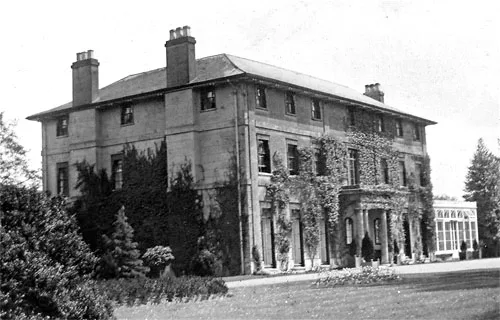
Caddington Hall
Stately homes · 1.0 km

Woodside Animal Farm & Leisure PArk
Zoos & aquariums · 1.7 km

Woodside Farm and Wildfowl Park
Zoos & aquariums · 1.7 km

Aley Green
Towns & cities · 1.9 km

Lynch House
Historic houses · 2.1 km

Lower Woodside
Towns & cities · 2.2 km

Pepsal End Manor
Manor houses · 2.6 km

Flamstead
Villages · 2.8 km

Caddington
Towns & cities · 2.8 km

Flamstead War Memorial Set on Churchyard Wall
Memorials & monuments · 2.8 km

The Spotted Dog Public House
Historic pubs · 2.8 km
Nearby
📷 5Memorials & monuments · East of England
Markyate War Memorial
Markyate War Memorial — Grade II listed building-listed memorial in england-london, United Kingdom.
📷 5📷 5Zoos & aquariums · East of England
Woodside Animal Farm & Leisure PArk
Woodside Animal Farm & Leisure PArk — a zoo aquarium in england-london, United Kingdom.
📷 5Zoos & aquariums · East of England
Woodside Farm and Wildfowl Park
Woodside Farm and Wildfowl Park — zoo in Slip End near Luton, Central Bedfordshire.
📷 5📷 5Historic houses · East of England
Lynch House
Lynch House — house in Kensworth, Central Bedfordshire, England, UK.
Where to eat & stay near Markyate
Places to stay
 📷 5
📷 5Hostels · East of England
Stockwood Hotel
Stockwood Hotel — a hostel in england london.
 📷 7
📷 7Hotels · East of England
The Red Lion hotel
The Red Lion hotel — a hotel in england london.
 📷 7
📷 7Hotels · East of England
Spark by Hilton Luton
Spark by Hilton Luton — a hotel in england london. 4-star. Brand: Spark by Hilton.
 📷 5
📷 5Hotels · East of England
Hampton by Hilton London Luton Airport
Hampton by Hilton London Luton Airport — a hotel in england london. 3-star. Brand: Hampton.
 📷 5
📷 5Hotels · East of England
Aubrey Park Hotel
Aubrey Park Hotel — a hotel in england london.
 📷 5
📷 5Campsites · East of England
Highridge Farm Camping
Highridge Farm Camping — a campsite in england west midlands.
Places to eat & drink
📷 5Historic pubs · East of England
The Spotted Dog Public House
The Spotted Dog Public House in England East, United Kingdom.
 📷 7
📷 7 📷 5
📷 5Historic pubs · East of England
Ye Olde Chequers Public House
Ye Olde Chequers Public House in England East, United Kingdom.
 📷 5
📷 5Historic pubs · East of England
The Fountain Public House
The Fountain Public House in England East, United Kingdom.
 📷 5
📷 5 📷 5
📷 5Historic pubs · East of England
The Holly Bush Public House
The Holly Bush Public House in England East, United Kingdom.
More places in this region


Frequently asked questions
- Where is Markyate?
- Markyate is in Hertfordshire, London, United Kingdom (postcode AL3 8PG), in the parish of Markyate.
- What is Markyate?
- Markyate — a village in england london.
- How do I get to Markyate?
- The nearest railway station is Whipsnade Central, about 5.4 km away. Drivers can use postcode AL3 8PG.
- Is Markyate a protected site?
- Yes — Markyate is part of the Chilterns National Landscape (AONB).
- How do I get to Markyate?
- The nearest railway station is Whipsnade Central, about 5.4 km away. Drivers can navigate to postcode AL3 8PG.